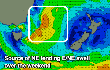
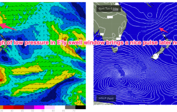
As it does it aims up the fetch of E/NE winds into the NETas swell window and we’ll see increasing swells from the NE direction o/night and into Sat.
Primary tabs
/reports/forecaster-notes/eastern-tasmania/2025/05/23/pumping-surf-the-ne-ene-over-the-weekend-strong
freeride76
Friday, 23 May 2025
/reports/forecaster-notes/eastern-tasmania/2025/05/21/dynamic-period-solid-ne-then-s-swell
Craig
Wednesday, 21 May 2025
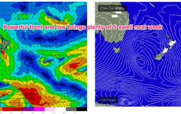
We'll see building levels of NE tending E/NE swell this period follow by a windy, cold S'ly swell.
/reports/forecaster-notes/eastern-tasmania/2025/05/19/quality-ene-swell-likely-end-the-week-lowtrough
freeride76
Monday, 19 May 2025
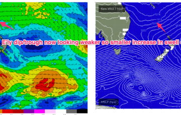
These small lows may move north, then east and finally south or may coalesce in a more classic Tasman Low or ECL variant. Either way we should see some quality E/NE swell for Tas as the fetch draws out through the Tasman.
/reports/forecaster-notes/eastern-tasmania/2025/05/16/nice-ene-swell-due-next-week-tasman-low-drifts
freeride76
Friday, 16 May 2025
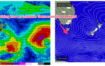
By mid week the trough of low pressure in the Tasman is expected to be moving southwards towards the NSW south coast.
/reports/forecaster-notes/eastern-tasmania/2025/05/14/small-s-swell-pulses-incoming-possible-ecl-nsw
freeride76
Wednesday, 14 May 2025
Next week still looks dynamic with potential for a deep trough or low in the Tasman, although we are going to have to play it day by day due to poor model to model and run to run consistency.
/reports/forecaster-notes/eastern-tasmania/2025/05/12/small-fun-swells-filter-down-the-tropics-s
freeride76
Monday, 12 May 2025
A broad trade fetch on steroids is now slowly breaking down through the Coral, Tasman and South Pacific with a tropical low whizzing away to the SE.
/reports/forecaster-notes/eastern-tasmania/2025/05/07/mix-s-swells-and-small-ene-swells-the-tropics
freeride76
Wednesday, 7 May 2025
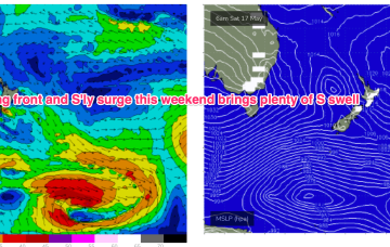
In between, a trough and cold front are currently approaching Tasmania, expected to bring a vigorous W/SW-SW flow o/night into tomorrow, bringing a spike in short range S swell short term.

/reports/forecaster-notes/eastern-tasmania/2025/05/05/small-mixed-bag-week-fresh-offshore-winds
freeride76
Monday, 5 May 2025
We’ll see the current dominant high (1034hPa) straddling New Zealand which is directing a broad trade fetch through the South Pacific and into the Coral Sea slowly migrate eastwards this week with an E’ly dip forming a trough of low pressure due E of SEQLD mid week.
/reports/forecaster-notes/eastern-tasmania/2025/05/02/surf-easing-back-tinyflat-the-weekend-under
freeride76
Friday, 2 May 2025
We should see some better quality E/NE swell from a southwards moving low pressure trough which moves from the South Pacific into the Northern Tasman next week.
/reports/forecaster-notes/eastern-tasmania/2025/04/30/small-good-quality-swells-the-rest-the-week
freeride76
Wednesday, 30 April 2025
Remnants of a low on the weekend are also sitting near New Zealand with swell generating fetches off the South Island and emerging from Cook Strait into the eastern Tasman. Swells from the New Zealand fetches keep surf zones active into the end of the week with mostly offshore to light winds into the weekend.
