Indonesia/Maldives forecast Jul 3

Indian Ocean Basin analysis by Craig Brokensha (issued Thursday 3rd July)
This week through next (July 4 - 11)
We’ve got easing surf after a small lift in groundswell yesterday, though into this afternoon, an inconsistent, acute S/SW groundswell is due to build, offering the most size late and into dawn tomorrow.
This swell was generated by a polar low that fired up east of the Heard Island region over the weekend, with moderate sized sets due across selected south magnets.
We’re then looking at a slow weekend, with a long-range, inconsistent but moderate sized SW groundswell due into later Monday/Tuesday.
Another distant polar low to the south-east of South Africa generated this swell earlier this week, with it being inconsistent and only moderate in size but better than nothing.
We then look at the large S/SW groundswell due into the middle of next week, with a strong node of the Long Wave Trough expected to develop across Western Australia.
This will steer and strengthen a significant polar frontal progression up high into the south-east Indian Ocean, with an initial front due to set in motion an active sea state for a secondary stronger system to push up and over.
We’re set to see gale to severe-gale S/SW winds projected towards us, generating a large, consistent S/SW groundswell for Wednesday, filling in rapidly and peaking through the afternoon/evening, easing Thursday.

The current strong SE trades will persist tomorrow while easing a touch, similar Saturday before strengthening again from the E/SE Sunday, persisting next week from the E/SE-SE. Early each morning, light local land breezes are expected.
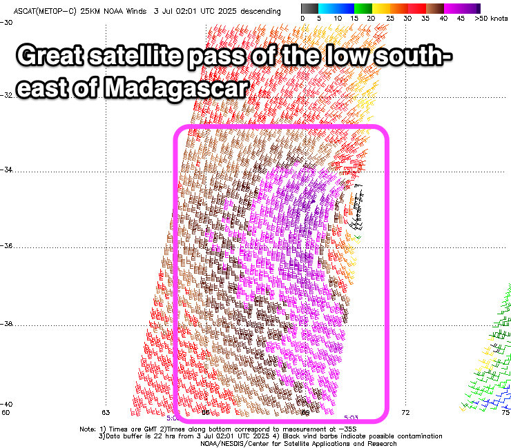
Over in the Mentawais, a strong mid-latitude low that’s currently weakening to the east-southeast of Madagascar has generated a great fetch of gale to severe-gale S’ly winds, and a large SW groundswell for Monday. This will come in better than the long-range swell.
The swell for Wednesday/Thursday next week will be more S’ly across the region but still be large.
Local winds look variable this period with southern regions at times seeing SE breezes though to no major strength.
----------------------------------------------
Maldives:
We’ve got easing levels of S/SE trade-swell across the region, though come the weekend a mix of S/SW groundswells are due to fill in, with a moderate sized increase Saturday due to be superseded by a larger S’ly groundswell Sunday.
This swell has been generated by the strong mid-latitude low forming south-east of Madagascar, with satellite observations picking up a great fetch of 40-45kt winds aimed towards the region.
Saturday will see building surf, with the peak in energy due Sunday, easing into Monday.
We then look at the super-charged trade-fetch setting up to our south initially, spreading east through next week.
This trade-setup will develop Sunday and reach full maturity through next week, resulting in a moderate to large S/SE tending SE swell event, building slowly Monday/Tuesday but reaching a peak in size through Thursday.

The trade-fetch looks to weaken a touch later week, resulting in a slow easing trend while swinging more SE in direction.
Looking at the local winds and the current setup with weak W’ly winds across northern locations, variable to the south will persist tomorrow and Saturday, with winds freshening a little out of the S-S/SE to the south from Sunday. They will be strongest Monday before tending more variable through the rest of next week while west winds persist across northern locations.
Eastern Indonesia:
Inconsistent, moderate sized S/SW groundswell for later today and tomorrow morning to 4ft+ across exposed breaks.
Inconsistent, moderate sized SW groundswell for Monday afternoon and Tuesday morning to 4-5ft+ across exposed breaks.
Large, consistent S/SW groundswell building Wednesday, reaching 10ft+ across exposed breaks, easing slowly Thursday.
Strong SE trades, easing a little tomorrow and Saturday, re-strengthening again from the E/SE Sunday, persisting next week from the E/SE-SE. Early each morning, light local land breezes are expected.
Uluwatu 16-day Forecast Graph/WAMs
Western Indonesia/Mentawais/South Sumatra:
Smaller surf tomorrow and into the weekend.
Large sized SW groundswell for Monday to 6ft+ across exposed breaks, easing Tuesday.
Large S’ly groundswell building Wednesday afternoon, peaking Thursday morning to 8-10ft across exposed breaks.
Variable winds this period, tending SE at times across southern locations.
Mentawai 16-day Forecast Graph/WAMs
Maldives:
Easing S/SE trade-swell tomorrow.
Moderate sized S/SW groundswell building Saturday, peaking into the afternoon to 4-5ft across southern locations, smaller Male.
Large S’ly groundswell Sunday, peaking to 5-6ft across the southern atolls, smaller Male.
Super-charged S/SE trade-swell building slowly Monday/Tuesday, stronger Wednesday and peaking Thursday to 6ft+ across the southern atolls, smaller Male.
Swell easing slowly from Friday while tending more SE in direction.
Light to moderate W winds across northern locations, variable to the south. Freshening S-S/SE winds across southern locations Sunday, strongest Monday, weakening and becoming more variable from Tuesday again.
Comments
Latest notes are live.
Cheers Craig, looking forward to it (with some trepidation) …looks like the new swell hits late wed morning. A couple of years ago I was at impossibles when a new swell hit, 20 wave set cleaned everyone up and by the time it had subsided the entire pack had been washed down to Bingin…
Keen as for these new notes thank you lord craigos :)