Good couple of days for exposed breaks, tricky swells next week

Victorian Forecast by Craig Brokensha (issued Friday July 4th)
Best Days: Today, exposed beaches tomorrow and Sunday AM, Monday, Wednesday, Friday Surf Coast
Features of the Forecast (tl;dr)
- Small mid-period S/SW swell easing tomorrow with gusty N/NE winds tomorrow, easing while shifting more NE into the PM
- Small Sun with light-mod N/NE-NE tending variable E winds
- Small mid-period SW swell Mon with NW winds to the west and N-N/NW winds to the east (possibly N/NE later)
- Tiny Tue with strong N winds
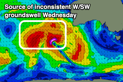
- Building, moderate sized, inconsistent W/SW groundswell Wed with strong N/NW winds (check back Mon for any upgrade)
- Mix of swells Thu, with a building windswell under strong S/SW-SW winds
- Moderate sized, inconsistent W/SW groundswell Fri with W/NW tending W/SW winds
Recap
Winds backed off and became variable yesterday morning with the surf improving quite nicely across most breaks. The Surf Coast was still 3ft or so with peaky, fun conditions while to the east we saw 3-5ft waves with a favourable tide early and late.
This morning conditions are cleaner again with local offshore winds and a little less size, though a reinforcing mid-period S/SW swell is still maintaining 2ft+ waves on the Surf Coast with 4ft+ sets to the east.
This weekend and next week (Jul 5 - 11)
A final pulse of mid-period S/SW swell due later today is expected to ease back through tomorrow, with the Surf Coast dropping from 2ft+, with 4ft waves to the east, smaller through the day and then down a touch more Sunday.
Winds are still expected to favour the beaches with a gusty N/NE breeze due tomorrow morning, shifting more NE into the afternoon while easing, with Sunday seeing light to moderate N/NE-NE winds, swinging more variable E’ly into the afternoon.

Into Monday, our small lift in mid-period SW swell is on track, generated by a weak polar front moving under the country today and tomorrow. This should provide 2ft+ waves across the Surf Coast and 4ft sets to the east as winds hold from the NW all day on the Surf Coast and come from the N-N/NW to the east, possibly shifting N/NE later.
Tuesday looks like a lay day with easing surf under strengthening N’ly winds, and then we look at the incoming swell for Wednesday onwards.
A strong node of the Long Wave Trough is expected to develop across Western Australia, steering strengthening polar frontal activity up and across the region. An initial couple of strong systems developing this weekend will generate fetches of severe-gale W/SW winds through our western swell window, weakening and splitting once pushing through the Bight Monday.
The developments once the remnants move towards us through the middle of next week are still up for grabs with American model GFS showing a re-intensification right on our doorstep while the European solution ECMWF having none of it.
Instead we’ll see the groundswell from the earlier stages of the progression peaking through Wednesday afternoon, coming in from the W/SW and being moderate in size. Inconsistent 4ft sets are likely on the Surf Coast magnets with 6ft+ waves to the east under strong N/NW-N winds.
Unfortunately come Thursday, a secondary, high riding mid-latitude low looks to move across us, bringing strong S/SW winds and some local windswell as the groundswell from Wednesday eases.
So all in all this progression looks to be less than ideal, a bit too far north and the swell to west as cautioned in the notes earlier this week.
We’ll have another look Monday though to see if the more promising outlook forecast by GFS for Wednesday swell wise comes to fruition.
Winds are expected to shift back around to the W/NW on Friday with a new pulse of moderate sized W/SW groundswell, generated by the earlier stages of the northward tracking mid-latitude low,
Next weekend also looks promising with NW winds and some moderate sized W/SW-SW groundswell on the cards. More on this Monday, have a great weekend!
Comments
Thanks for the report craig! Just wondering what size you expect on the beaches east of Melbourne Sunday? Bit hard to tell from the report
Probably 3-4ft.
Some whale action on the Rye cam from 3.52pm today. A few breaches moving from right to left of screen.
Unconfirmed shark sighting Eastern View this afternoon.