The coming week looks to be the best of the period.
Primary tabs
/reports/forecaster-notes/eastern-tasmania/2025/03/17/fun-south-east-followed-north-northeast
Craig
Monday, 17 March 2025
/reports/forecaster-notes/eastern-tasmania/2025/03/14/frontal-systems-bring-s-swells-and-seasonal
freeride76
Friday, 14 March 2025
SW gales push through Bass Strait and adjacent to the Tasmanian East Coast Sun night and into Mon.
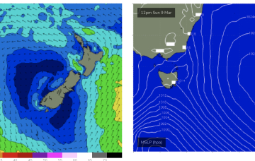
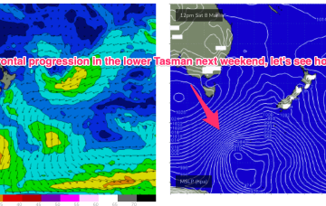
/reports/forecaster-notes/eastern-tasmania/2025/03/12/pulses-the-south-ahead-seasons-shift
freeride76
Wednesday, 12 March 2025
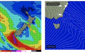
To the south we are seeing strong, but zonal frontal activity which will impact the Island state with local winds and S swells later next week.

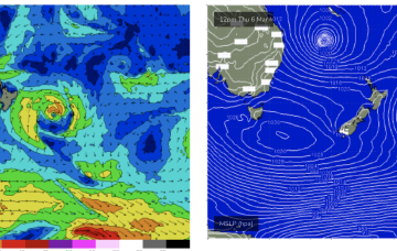
/reports/forecaster-notes/eastern-tasmania/2025/03/10/tropical-action-dies-down-swells-the-s-the
freeride76
Monday, 10 March 2025
Action from the south is on the radar for next week, after an extended period of tropical action dies down. First cab off the rank is a frontal system and trough which looks to push across Tas later Sun into the Tasman o/night into Mon.

/reports/forecaster-notes/eastern-tasmania/2025/03/07/swells-tc-alfred-easing-over-the-weekend
freeride76
Friday, 7 March 2025
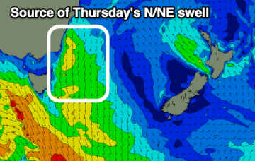
We should see a round of NE windswell Wed as high pressure in the Tasman and an approaching cut-off low briefly tighten pressure gradients with NE winds increasing and swell building during the day.
/reports/forecaster-notes/eastern-tasmania/2025/03/05/chunky-ene-swells-tc-alfred-peak-over-the-next
freeride76
Wednesday, 5 March 2025
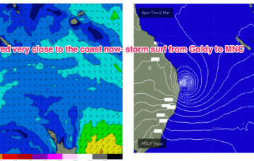
Massive surf from the Moreton Bay Islands across the Gold Coast and down through Northern NSW will continue until the cyclone crossing, with much smaller surf on the Sunshine Coast and into temperate NSW and down to Tasmania.

/reports/forecaster-notes/eastern-tasmania/2025/03/03/fun-surf-tc-alfred-reaches-tasmania-other-swell
freeride76
Monday, 3 March 2025
Alfred is expected to move SE today, generating mod to large swells down the NSW coast (it’s already solid in the sub-tropics!) and reaching all the way down to Tasmania.
/reports/forecaster-notes/eastern-tasmania/2025/02/28/more-small-surf-the-tropics-next-week-depending
freeride76
Friday, 28 February 2025
There are some model runs suggesting it penetrating the Tasman and developing a large wind field across the Tasman that would see larger E’ly swells into late next week.
/reports/forecaster-notes/eastern-tasmania/2025/02/26/small-surf-filtering-down-the-tropics-continues
freeride76
Wednesday, 26 February 2025
High pressure is in the Tasman with three tropical cyclones currently on the map. NETas will see some smaller surf from these systems as well as NE windswell.
/reports/forecaster-notes/eastern-tasmania/2025/02/24/small-swells-the-ene-filtering-down-the-tropics
freeride76
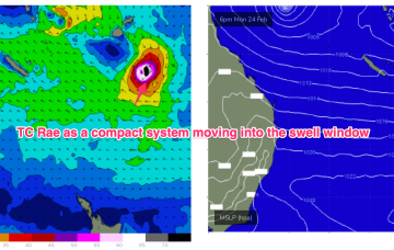
Monday, 24 February 2025
The trade-wind fetch is relatively robust and will be a long-lasting swell producer for the east coast, favouring sub-tropical areas for size with some small swell filtering down to NETas through the week.