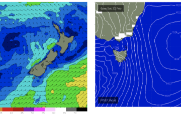
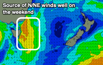
High pressure has moved into the Tasman and sits there over the weekend. It’s quite a strong high (expected to strengthen from 1025 to 1030 hPa) with a typical wind signature for this time of year- mod/fresh SE winds in the sub-tropics, tending to NE winds in temperate NSW and extending down to Tasmania.
Primary tabs
/reports/forecaster-notes/eastern-tasmania/2025/02/21/sizey-ne-windswell-sun-then-not-much-next-week
freeride76
Friday, 21 February 2025
/reports/forecaster-notes/eastern-tasmania/2025/02/19/sizey-ne-windswell-weekend-then-not-much-action
freeride76
Wednesday, 19 February 2025
Following that, high pressure moving into the Tasman will supply another round of NE windswell over the weekend.
/reports/forecaster-notes/eastern-tasmania/2025/02/17/inconsistent-ene-swell-come-windy-building
Craig
Monday, 17 February 2025
There's still a fun though inconsistent E/NE swell inbound ahead of small south swells, and a stronger N/NE windswell on the weekend.
/reports/forecaster-notes/eastern-tasmania/2025/02/14/great-few-days-surf-ahead
Craig
Friday, 14 February 2025
We've got a mix of easing E/NE energy and building S/SE swell with decent winds.

/reports/forecaster-notes/eastern-tasmania/2025/02/12/sizey-the-ne-then-s-over-the-weekend
freeride76
Wednesday, 12 February 2025
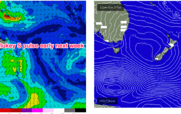
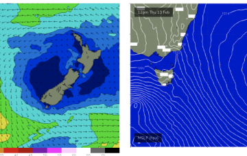
An active monsoon pattern is seeing a tropical low drifting in the Coral Sea with a supporting high approaching New Zealand and a slow moving trough line just off the NSW Coast, directing strong N’ly winds down into Bass Strait and adjacent to Tasmania.
/reports/forecaster-notes/eastern-tasmania/2025/02/10/local-ely-swells-short-term-sizey-spike-in-ne
freeride76
Monday, 10 February 2025
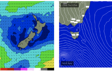
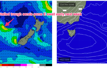
Thursday sees a solid spike in NE windswell as N’ly winds ramp up from the South Coast across Bass Strait and adjacent to NETas.
/reports/forecaster-notes/eastern-tasmania/2025/02/07/active-period-ahead-plenty-swell-and-onshore
freeride76
Friday, 7 February 2025
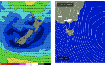
Surf builds into the new week as high pressure drifts SE of the Island and the trough stalls off the Southern NSW coast, directing SE-E winds at Tas and generating some chunky E/SE-E swell.
/reports/forecaster-notes/eastern-tasmania/2025/02/05/easing-swells-the-weekend-active-period-after
freeride76
Wednesday, 5 February 2025
The next S’ly change pushes into Tas Fri before stalling, with a useful fetch of SE-E winds aimed up at East Coast Tas.
/reports/forecaster-notes/eastern-tasmania/2025/02/03/ne-windswell-peaks-tues-another-round-next-week
freeride76
Monday, 3 February 2025
A high pressure in the centre of the Tasman is directing SE-E winds across the sub-tropics, more NE in temperate regions extending down to the Island state. We’ll see more NE windswell episodes in the f/cast period.

/reports/forecaster-notes/eastern-tasmania/2025/01/31/fun-round-ne-windswell-sun-peaking-tues
freeride76
Friday, 31 January 2025
A more classic looking summer chart to start next week with high pressure in the Tasman and low pressure centres near New Caledonia and in the South Pacific slot, with a healthy E’ly tradewind fetch extending across most of the Central and Southern Coral Seas and NE winds in the NETas swell window.