Good for the South Coast magnets, large and stormy next week

South Australian Forecast by Craig Brokensha (issued Wednesday July 2nd)
Best Days: Keen surfers Friday, beaches Saturday morning, keen surfers Tuesday and Wednesday mornings
Features of the Forecast (tl;dr)
- Easing surf tomorrow with N/NW tending variable winds
- Small mid-period S/SW swell for Fri and Sat AM, easing
- N/NE winds Sat
- Moderate sized mid-period W/SW-SW swell building Sun, easing Mon
- Strengthening N-N/NW Sun, tending NW later
- Small-mod sized mid-period SW swell Mon with strengthening N/NW tending N winds
- Large, stormy swell building Tue with strong W/NW tending W winds
Recap
The surf improved across the South Coast yesterday though still came in a little lumpy with 3ft sets across Middleton and weak sea breezes. The Mid Coast picked up a little pulse in swell to 1.5ft+ with light winds all day.
Today the Mid Coast is tiny and the South Coast nice with light winds and 3ft of swell across Middleton again.
This week and weekend (Jul 3 - 11)
The coming days look great for the magnets across the South Coast as we see today’s S/SW groundswell backing off in size, easing back from 2-3ft tomorrow morning and then to 2ft+ on Friday.
Saturday morning could still come in a similar size, thanks to background levels of mid-period S/SW swell filling in Friday, easing into the weekend.
These pulses of S/SW energy will be generated by a couple of polar fetches of strong to gale-force W/NW winds today.
All day offshore N/NW tending variable winds are due tomorrow with Friday seeing persistent N/NE winds, stronger N-N/NW on Saturday ahead of a late shift to the NW.

Sunday is a funky one, with a trough expected to see early SW winds shifting back to the W/NW ahead of an approaching frontal system, back to the W/SW into the afternoon.
The trough will bring with it a small increase in mid-period swell for both coasts Sunday, likely building to 1-2ft across the Mid Coast but with bumpy conditions and 2-3ft down South with those tricky winds.
Monday looks like a better option with a new mid-period SW swell due to fill in, generated by a short-lived polar frontal system forming east of the Heard Island region tomorrow. A broad fetch of strong W/NW winds should kick up a small increase to 2ft+ across Middleton under strengthening N/NW tending N’ly winds.
With the smaller stuff out of the way, we then look to a significant frontal progression moving in through next week, under the influence of a strong node of the Long Wave Trough.
We’re set to see a strong cold outbreak project up and across Western Australia, this Sunday/Monday, likely res-strengthening right on our doorstep (in the Bight) Monday evening/Tuesday.
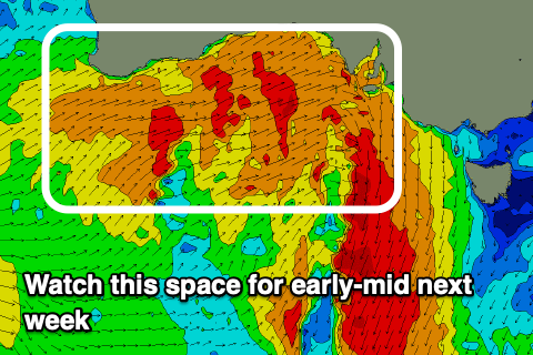
A significant fetch of gale to severe-gale W/SW winds are due to set in motion a large W/SW groundswell for Tuesday, with secondary activity likely generating a secondary swell for Wednesday.
The progression will move across us at the same time, bringing damaging stormy conditions to the gulfs, with the South Coast offering the best waves in protected spots.
Continued activity into the end of the week and weekend should continue to provide moderate to large levels of swell into next weekend and beyond. More on this Friday.
Comments
Any reports on the algae bloom for south Coast?
@Aaaandy - updates are being posted here - https://www.facebook.com/groups/1885987812164667
Stay out of the water! You could catch something really really bad. Don't take any risks!!!