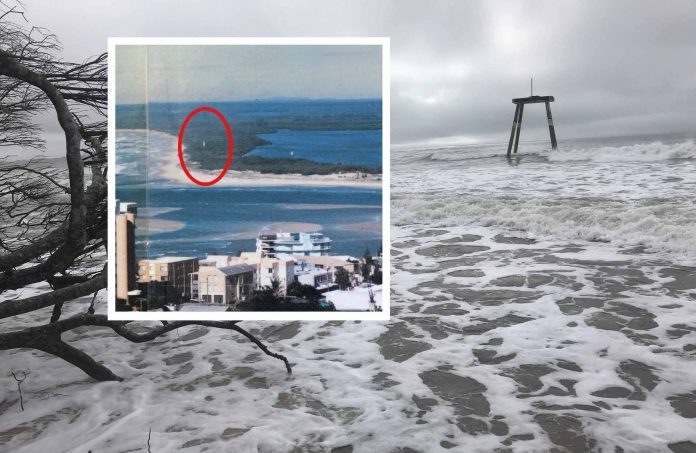
Cyclone Seth Splits Bribie Island, New Channel Permanent

In 1898, a storm event overtopped a narrow isthmus on Stradbroke Island and split the barrier island into two halves. The combined efforts of waves and tidal flow saw the channel grow and become a permanent bar - the infamous Jumpinpin - while South Stradbroke and North Stradbroke became distinct islands.
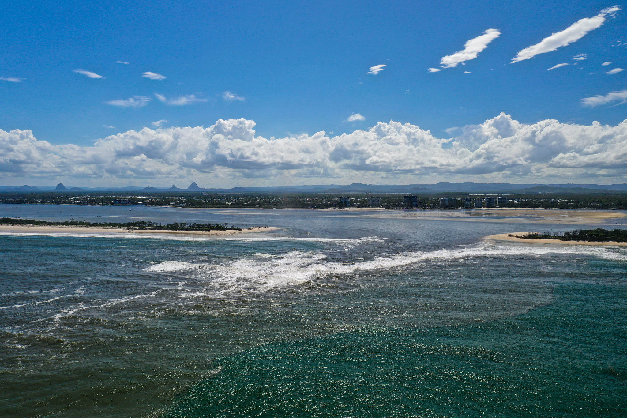
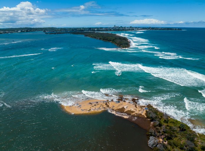
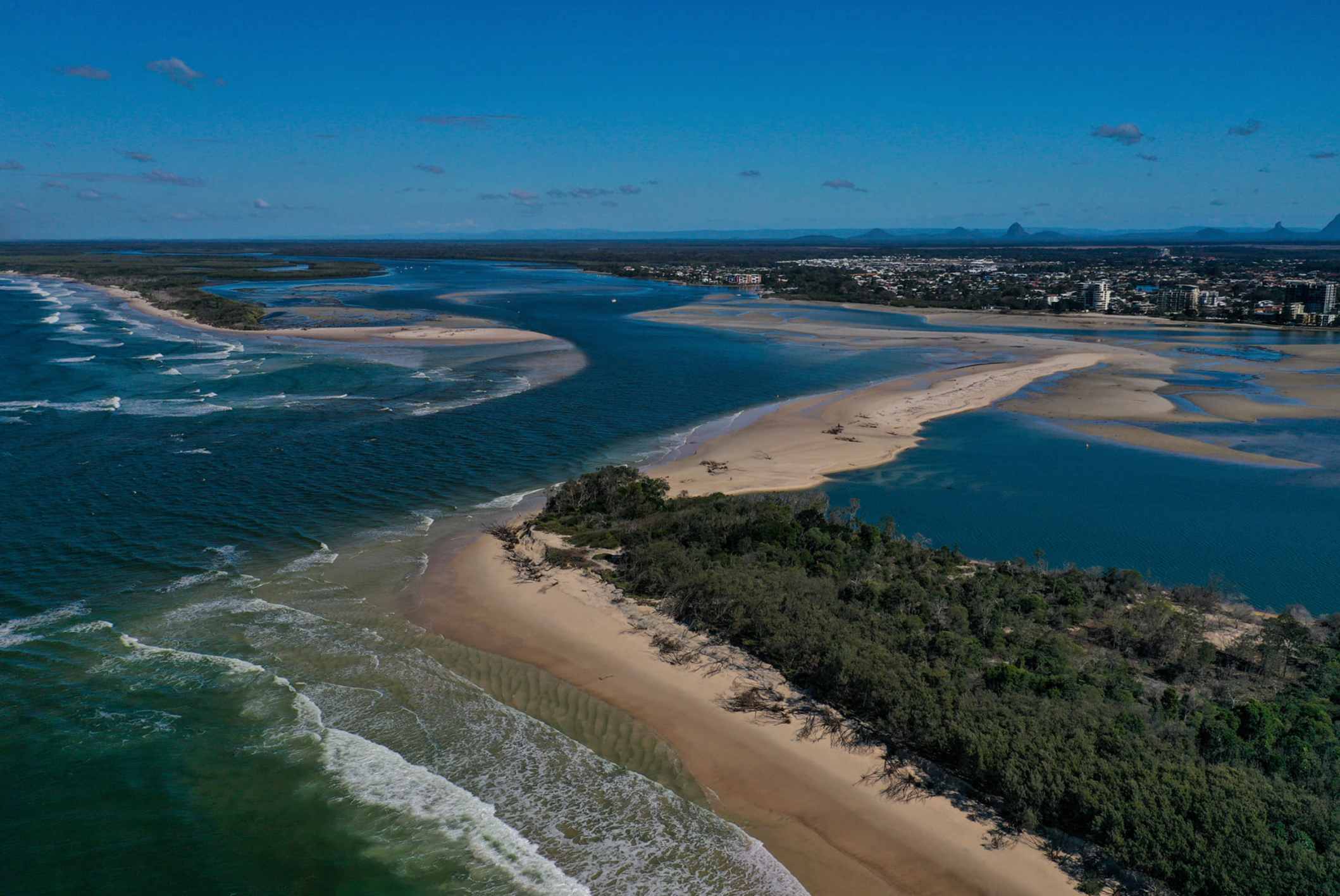
Earlier this month, another of south-east Queensland’s barrier islands was split and scientists believe the result will, like Stradbroke, be permanent.
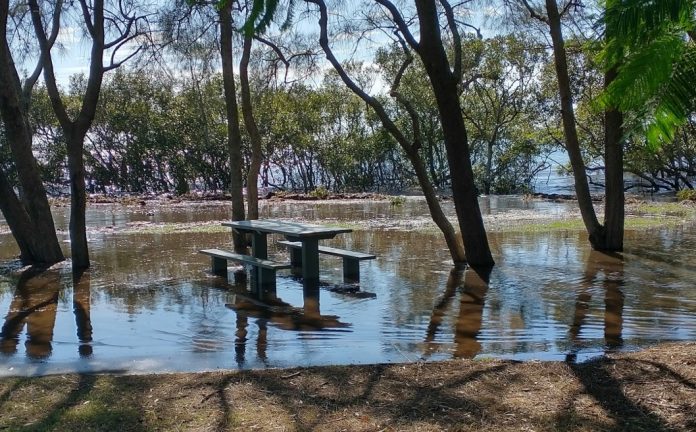
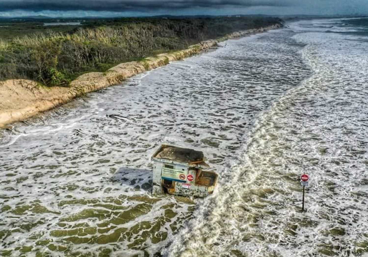
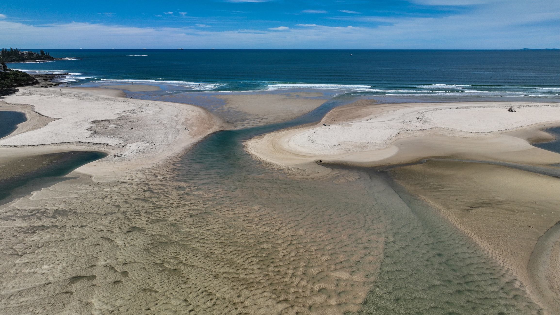
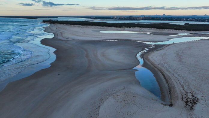
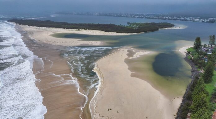
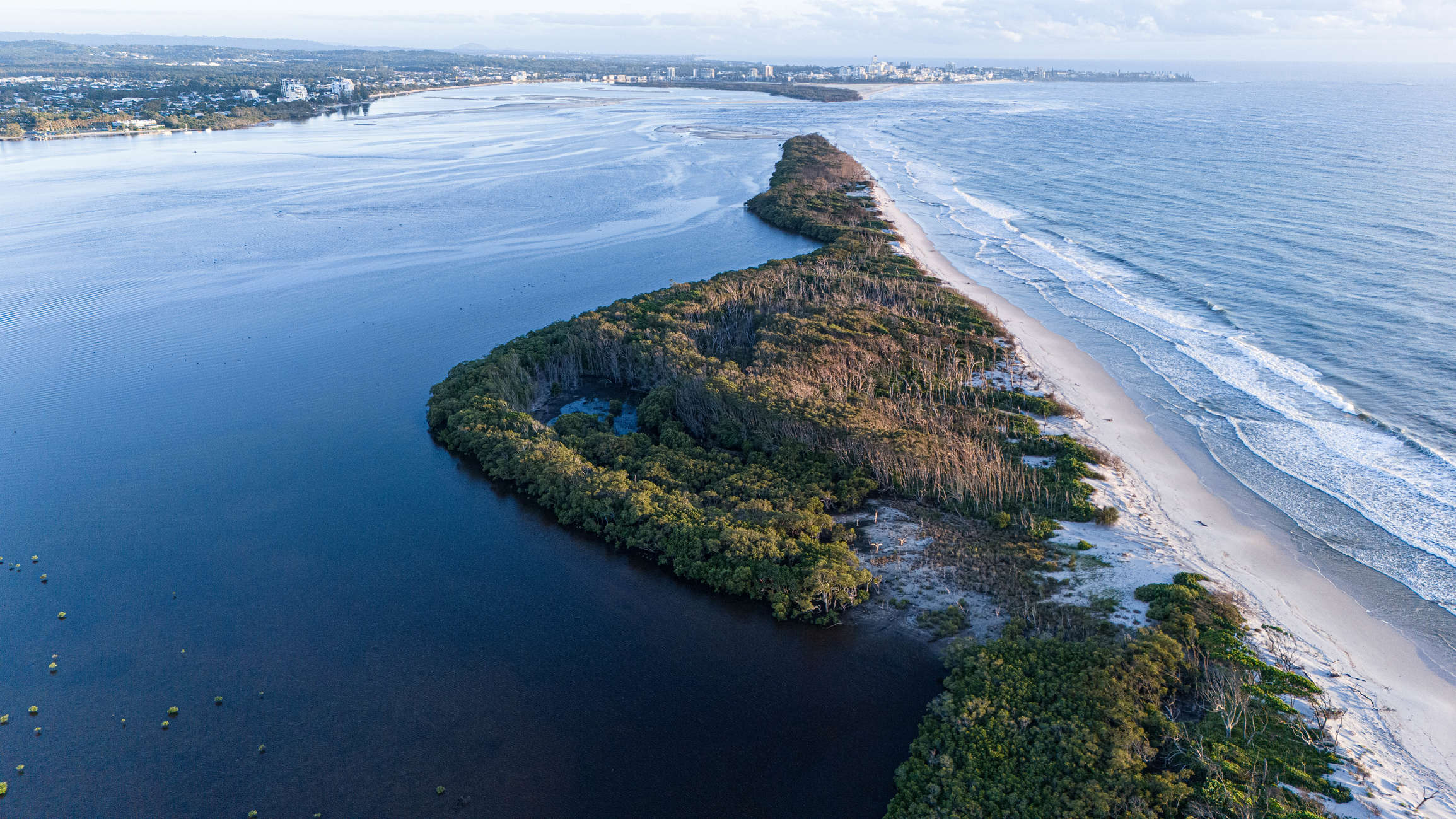
On the 2nd January, with swell from Tropical Cyclone Seth battering the ocean side, and an associated deluge raising water levels in Pumicestone Passage, Bribie Island was split, with waves breaking through a narrow spit at the northern end.
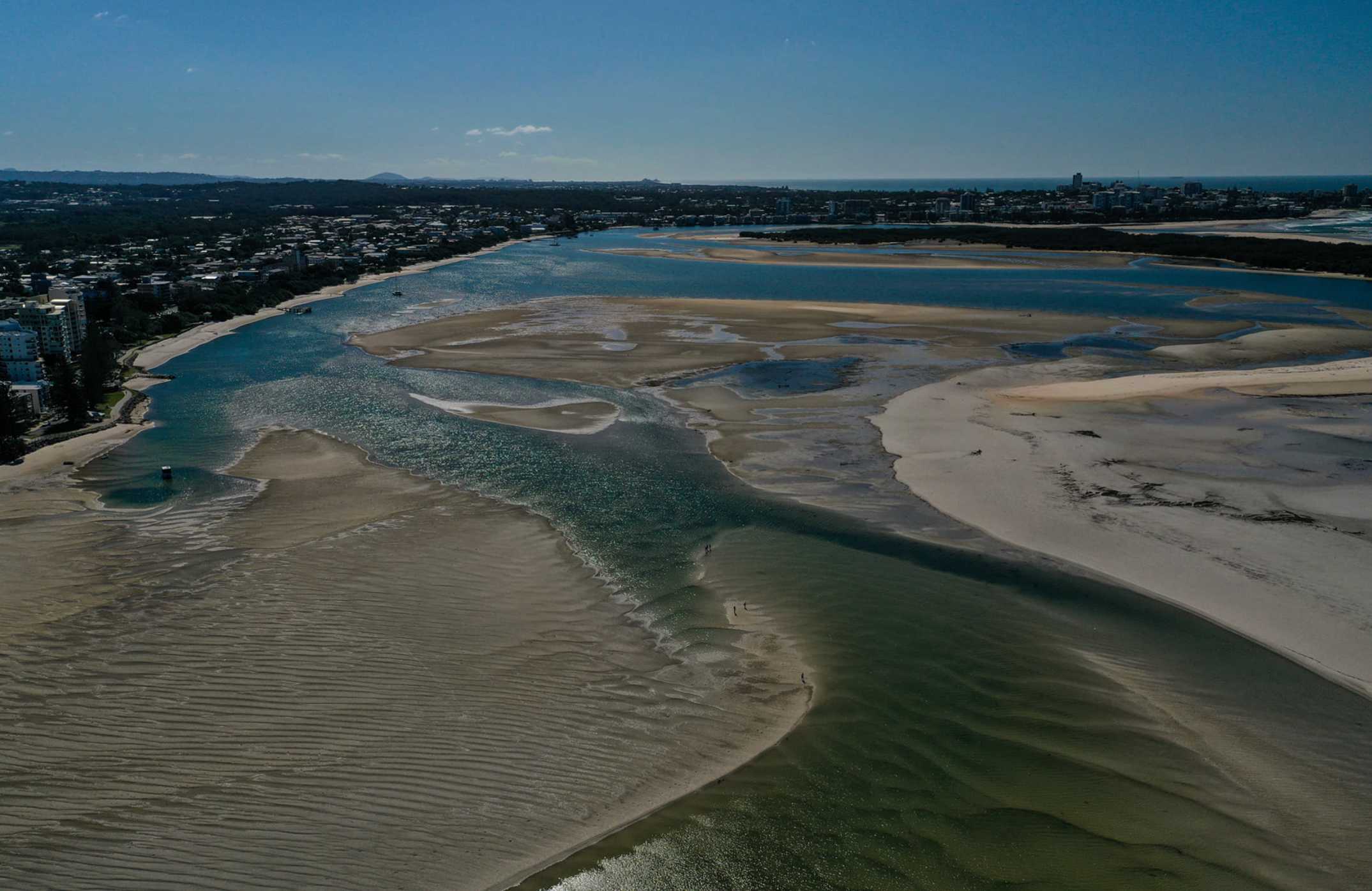
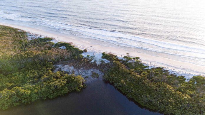
Aerial photographs show the extent of the breach.
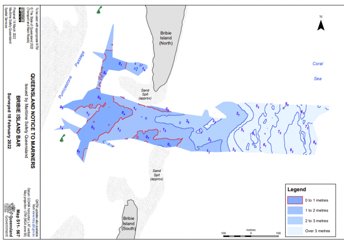
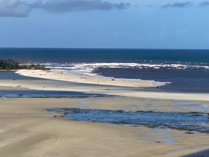
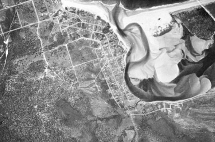
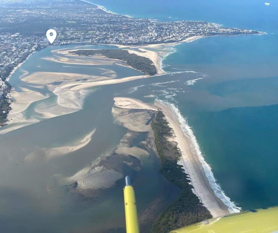
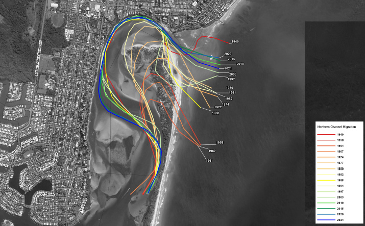
Northern Bribie Island has a long history of shifting sands. In the early 1970’s the entrance to Pumicestone Passage was well south of its present location at Caloundra and just north of the new entrance position (see image below).
More recently, waves overtopped and eroded the island in December 2020, however it wasn’t enough for a channel to form.

On January 4th, the Principal Scientist from Queensland’s Department of Environment and Science (DES) visited the site, observing the newly formed tidal channel. The formation of said channel leads the DES to believe that this will become the new northern entrance to Pumicestone Passage and that Caloundra Bar will slowly fill with sand.
Surfers will greet the news with mixed emotions as, though fickle, Caloundra Bar offers respite from northerly winds. No longer will the banks there be groomed by tidal flow. Conversely, the new channel, though more exposed to wind, is showing promise with a left and right on each side.
Locals will soon get a look at those waves, as starting tomorrow a fresh round of easterly swell from TC Cody will hit the coast, and like the last swell it will be a sustained event lasting till this time next week. The DES said it’s “not possible to speculate on whether any further washovers or breakthroughs will occur in nearby sections of the island”.
As the new channel is a naturally occurring event there are no planned remedial actions.
Comments
Suspect shadow swimming through the left hander in the first photo when zoomed in?
the people from clowntown aren't the real locals
No locals in a national park, just lots of sharks
That'll be interesting to watch and see whether the longshore sediment cycle fills the breach in. Many variables! Love to be having a fish there, though....
For a real time assessment of coastal dynamics it'll be great to watch.
Considering the swell to come (and a la nina summer yet to play out), plus the fact a tidal delta has already formed, my money is on this remaining the channel for a while to come.
An excellent one to watch, my feel is that is the new entrance now and it looks like it's already silting and diverting north of the channel and will close to the north as stated by DES.
Dec 2021

Jan 2022

Given that they're qualified coastal engineers, that's where my money would be too, but it will still be interesting to see how it pans out eg whether Coriolis influences water flow within the entrance system - my understanding is that it's Coriolis which influences at least the smaller estuarine entrances arising from breaches to meander north across beaches - and whether those estuarine sandbars in proximity to the entrance are stable enough to maintain the resistance. A substantial flow which the current entrance can't handle or erode fast enough to accommodate could bring the northern section back into play. And a whole lot of other factors of which we will no doubt experience over the coming 6 months at least.
I'm not sure people are aware of the strength of the tidal flow through Pumicestone passage either.
Lots of tidal flow.
Yeah which has now totally been diverted switching the whole coastal process setup.
And now it's a paddle across 2 rushing passes, if it's not ruined now. It's RARELY worth it, and usually half the size and quality of most beaches further up (swell loses a lot of energy getting in there) but I've had it as good as pumping TOS before, know your tides, the sand packs like concrete too. The core group over there won't be happy it's in everyone's minds now.
Yep, everybody can fuck right off from my homebreak, if people think its shit and fickle - good, fuck off and never check it and leave it to us.
freeride around 1.5-2 hrs after high yesterday it was ripping out through there ,
Remember this wave at Caloundra Bar (RIP) during Cyclone Victor back in 2016?
That first bloke was into that if he'd done two more strokes.....
I thought second guy in white could’ve stroked in easy but had the most half arsed paddle you could imagine.
Qlders
Wonder if that first guy still regrets being such a pussy cat
Would haunt you for the rest of your life eh.
So that’s the river mouth there?
A. Is there more footage to confirm more waves of that quality?
B. Has it come remotely close to that before/again?
C. Anyone crowdfund my time machine?
I lived in the old caravan park for a while up the inlet about a Km from the bar, I was true trailer trash and it was kind of fun good community vibe, the bar was the wave i use to surf whenever it broke even if a foot or two, fickle as all fuck and a real hard wave to surf and work out so shifty and lot of water moving around much harder to surf than Goldie point waves and super rare to get it overhead, but I had some fun ones out there, would be kind of sad to see it go, even if a new wave is created.
Just quietly, Ive had a couple of the best sesh's off the northern tip of Bribie. Hard to get it on but when it all comes together...
In about 1890 the Macleay River used to flow out at Grassy Head but then broke through at South west Rocks near its current alignment in a big flood. The remnant channel near Stuarts Point is the Macleay Arm and it’s gradually silting up.
If the Bribie breakthrough becomes the dominant outlet will be interesting to see if it the existing channel starts to close up.
Yep, we were talking about this while putting the above article together.
Not quite as dramatic, but in 1999 the mouth of the Maroochy river shifted to the southside of Pincushion Island. I also thought that was the case at the Manning River, that Old Bar was, as its name implies, the old bar, and Harrington the new one.
Turns out Old Bar is still open and the Manning River is the only river in the southern hemisphere to have separate, permanent ocean deltas. The Nile is also a double delta river - store that away for future Trivial Pursuit games.
And though it wasn't natural, the entrance to the Shoalhaven River used to be at Shoalhaven Heads until Alexander Berry had his convicts dig Berry's Canal that connected the Shoalhaven with Crookhaven Rivers, the combined flow heading out at Crookhaven. The canal also created Comerong Island.
Wow re those last two sentences.
Very dynamic locations until the rock walls start appearing… be interesting to see if the navigation channels behind Bribie start getting impacted and there is then a push for training walls or similar.
With Old Bar, just check Google Earth before starting your Trivial Pursuit game, that entrance comes and goes, it broke through most recently in March 2021 floods after being closed for a while and may close up again. There have been various proposals for keeping it open permanently.
Are you disputing Wikipedia..?
Also, I think the 'groves behind Bribie are Ramsar listed so that's one further hindrance to getting rockwalls put in.
In the last big flood the orignial shoalhaven river entrance tore back open properly and is much wider now than it has been in a long time. For a while there quite sure it was actually closed up at that side.
Yeah saw what happened at Maroochy - the beach use to be 150-200m from the caravan park, now right in front, and the park lost about 30-40% of it's area. There were two caravan parks then.
I remember when they put the geotext bags along the front to stabilise the river mouth.
Got washed against them paddling in during the July 01 big east swell, was better than being dragged across rocks.
The Shoalhaven has broken through at the Heads many times since the original training of the entrance etc, but it generally only tends to do it as a result of riverine flooding rather than overtopping or wave action. The training of the current entrance also creates a very different hydraulic environment to Pumicestone, so that as soon as the flood flow decreases and the trained entrance dominates, the outflow of water at the Heads isn't sufficient to maintain a separate entrance and longshore transport fill it in. It creates a delta, too, but wave action, currents etc soon dissipate it and bring it back into alignment with the beach.
(Not my photos. Saved from the local paper at the time)
Shoalhaven heads 2020 flood.
You can see the canal in the maps image.
Great photos those last two.
Jeez, not much left on the northern side.
ive used to spend a lot of time there and out to the banks fishing years ago. that bar is sharky.
The Richmond and Evans Rivers might also fit this bill, except that it's a canal that links the two, just south of Woodburn.
Pretty sure mark philappusis had one delta.
Interestingly the hunter river delta used to join up with port Stephen's according to what I've read by geologists
Comerong island. What a wave! First surfed it in 97. Right hand wedges that on its day, can grind a couple hundred meters down the beach and deliver some of the most darkest sand spitting pits on that part of the east coast. Miss that wave so much. Just the vibe of waiting on one side of the river to catch the punt across, then parking and walking the track to come out on the beach to witness some absolute offshore groomed goodies. when we would get the odd cyclone swell and a report of a S/SW change in late summer/Autumn we would rush around trying to find petty money for the trip. Wonder how it breaks these days.
It will be safer for swimmers now so that's good.
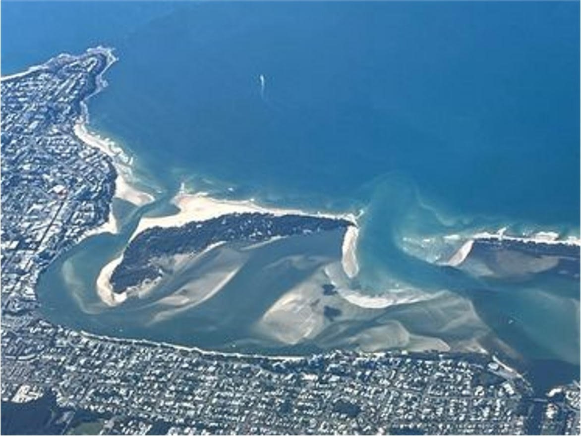
On balance it looks like the northern end of Pumicestone Passage is a flood delta and the south end is the where it drains out. Judging off the shape and orientation of the sandbars. The tide runs both ways at either end obviously, but I think more so in at the nth and out at the sth.
The relatively small amount of water escaping at Bulcock Beach (compared to the sth) would've caused some erosion and keeps it open, but I actually think that the inside of the island was eroded by the flood tide. Haven't been in there so I don't know if flowed sth fast against the bank in that particular spot but again, looking at the lobes of sand deposited, I'd say it was flowing southwards.
The erosion on the inside of the island (from the flood tide) did the bulk of the work in creating a narrow strip of island, but the run up of the waves was the straw that broke the camel's back. And now the ebbing tide will have to keep the ocean side from closing up. The inside still looks shallow so the new channel might meander or get blocked or whatever. But in the grand scheme of things, islands, points, grow northwards with longshore (sand) drift
The lighthouse used to be in the middle of the bush, it's footings have been completely exposed on the sand for ages now, it's lost a lot of seaward land too.
ah yeah is that where you weren't allowed to drive past?
Bribie is unique in that it's like a mini barrier island system within a larger barrier island system. It even looks like there's a channel off Bribie where Moreton Bay can drain out a bit faster than across the sand banks, and might be helping Bribie's foreshore retreat. You get these eddies of cold water from Pumicestone Passage, wrapping around the south end of Bribie too. So when you look at the whole bay it looks like it would erode along Bribie over a long period of time.
That's way further South for cars.
From this in 1988: https://takeactionpumicestonepassage.com.au/wp-content/uploads/2019/04/B...
To this in 2018: https://cranenetworknews.com/wp-content/uploads/2018/06/34962516_1928601...
oh yeah it must have been copping erosion from both sides
TAPP are off their head. Things change, so what. You can't geoengineer the crap out of the joint because one old chart and one way off angled photo suggests that 'nature' maintained the island width at 300m
Haha...spot on.
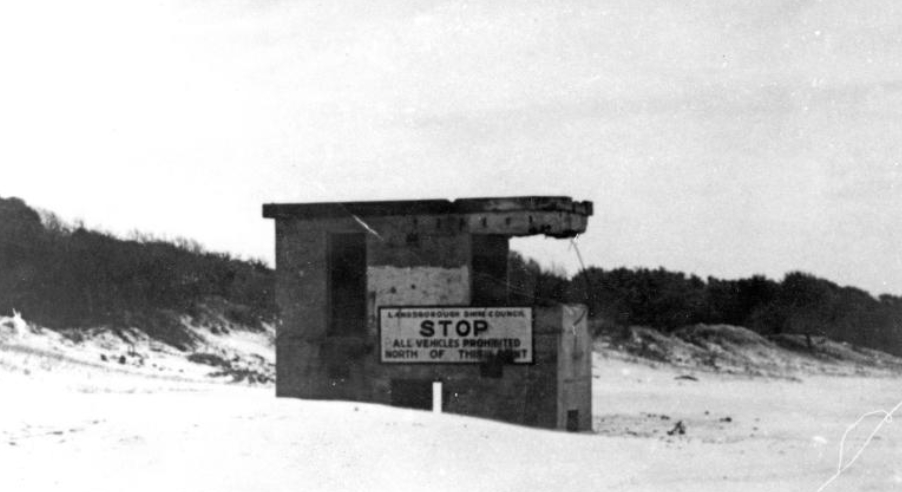
nah thats the stop sign bunker, had some good times camping in that bthing as a grom
So it's logical it will oficially become north and south bribie island i presume?
I wondered about naming too, however no-one's come up with anything yet.
'Spose it has to go through the Geographical Names Board
It'd take a few years i'd imagine to see how nature shapes the area.
Perhaps the northern entrance will fill in like some others commented here,thus negating the north side as physically being an island,and it becomes part of the mainland.
It's just a sliver strip of area anyway compared to south of the new channel so they'd likely rate it irrelevant for naming rights i'm thinking after looking at the complete map of the island.
It would have to become a dedicated permanent fixture, I'd say, and that would be quite some way off.
In Qld it's a slightly different system to the GNB in NSW, I think. Years ago I was asked to help the NSW GNB out with formal naming of some surf breaks....interesting process.
https://www.qld.gov.au/environment/land/title/place-names/naming
Tiger shark alley.
Seth's passage.
Calling Gary G to the main entrance!
I’m proposing Repulse Island. Repulse is the antonym of bribe according to Google.
Or you could go Gordon Nuttall Island. He loved a bribe
If it is going to be permanent , I wonder if they'll need to build a 'Wave Break Island' (similar to the Spit G.C) on that sandy patch in front of Golden Beach .?
https://www.sunshinecoastnews.com.au/2022/01/14/bribie-island-coastal-sc...
----------
“A key management principle of areas with high conservation and cultural value is to keep the areas as close as possible to its natural state, without human interference,” (Principal coastal scientist Sel Sultmann.)
“As this breakthrough is a naturally occurring event in a dynamic coastal environment at the tip of Bribie Island, there are no planned remedial actions."
----------
I can see a long line of developers lobbying council to build a new housing estate on the NEW Sth tip of Caloundra now that the land is becoming available. (Pss take) Their pitch will be it'll solve the SC housing crisis but I see it just adding to the dog poo problem. (insert sound bite of grinding axe)
White shoe island estates!
Yep was thinking the same. Will change the feel of that foreshore area in Caloundra too when most of that water dissappears.
Caloundra 'bar' and the 'Bulcock Beach' water stretch once handled a fleet of trawlers!
Here's a few links to some nice old pics:
https://lh4.googleusercontent.com/tlPWSflGBAfv4Pkn7KniZPK8BTs3xQbO4Al73A...
https://lh6.googleusercontent.com/FzaqbPWoLxLNUYuT40anB_4uQ_Wqc4Kdej9jR2...
https://lh3.googleusercontent.com/AsYx5e5qeLYLzuCMT-6tBL4zh41rmcZIFDpom4...
https://lh4.googleusercontent.com/DhRvrgMCjSyhsnbGxkBUgUNSgePXBYCy4IqiRL...
https://lh4.googleusercontent.com/xm9b2oqJ3DMxel5vqUec4OqzBwLjplkdrMGXAm...
Nice bit of history around Bribie, Caloundra and The Passage:
https://www.sunshinecoastplaces.com.au/caloundra/bribie-island/the-eastern
Bit about the old lighthouse on Bribie:
https://www.sunshinecoastplaces.com.au/caloundra/bribie-island
there was a big goanna in the old fort bunker , very surly bastard
Thanks for sharing Wingnut.
That was a great read.
Who cares what the learned “scientist(s)” have said after a quick “field” visit post comprehensive computer modelling.
I value the observation of dedicated intelligent locals.
I mean those that have decades of “lived” experience and perhaps longer as passed down.
Sand moves. We (surfers) do too.
So exciting to watch over the weeks, months, swells, seasons, years, and long period changes.
My local, a long RH point you are all familiar with, is changed, big time by a small gap in the rocks, either full, or empty of sand.
As Binky proved many moons ago.
'Who cares what the learned “scientist(s)” have said after a quick “field” visit post comprehensive computer modelling. I value the observation of dedicated intelligent locals.
I mean those that have decades of “lived” experience and perhaps longer as passed down.'
- what makes you think the 'learned' scientists aren't local, dedicated or intelligent? or old and experienced? most of them are crusty old greybearded surfers born from crusty old fisho's and beachcombing bra-less granny's who came down outta the forests in the 1800's on logs floating downstream for a feed of fuggin' oysters!
Go and put a new sticker on your boogieboard!
When I was a kid there used to be an annual Xmas carnival on a sandspit that extended out from Happy Valley. Used to be hundreds of meters of dunes. In time mother nature did her work and the channel moved up to where it has been the last 30+ years. The existing breakthrough is nothing new in my opinion - its where the original channel was in the 60s up to my childhood. Will the sandspit and carnies return? Who knows - the Rockwall at Happy Valley may prevent that happening. Either way, I am sure the recent development will be blamed on Global warming and Climate Change and there will be pressure to make some sort of man made engineered solution.....
The link below shows a few more pictures including a photo from the 60s and the "original" channel position.
https://www.sunshinecoastnews.com.au/2022/01/05/bribie-breakthrough/
In the mid 80's when I lived behind Jim Pollards house in Caloundra, Happy Valley extended a long way towards Bribie. Was not only a real beach it had a dirt carpark in the middle of it. From memory it was twice the length of Kings Beach.
Salute to Stu & the Crew for the breakthru news..
Bribie Breakthru Timeline reward for the crew...
8 June 1933 > 2 part Breakthru (1st 75 Yards across > 2nd 200 yards across)
Has not affected the Old Channel 100 yards away...
https://trove.nla.gov.au/newspaper/article/84622673?searchTerm=Bribie%20...
1940 Channel was 50 metres from Headland
22nd Feb 1940 > Huge seas pound Bribie Island as far as they could reach?
As they were watching... a Freak Wave picked up the Shark Tower and carried it away.
Mr Goodwin retrieved it a quarter of a mile down the beach. (Logs / Tennis Balls washed up!)
https://trove.nla.gov.au/newspaper/article/187290949?searchTerm=Bribie%2...
30 Jan 1951 Cyclone filled in the Channel + (Page 5 BIB ) 2021 Newsletter
https://trove.nla.gov.au/newspaper/article/212097133?searchTerm=Bribie%2...
https://www.nhwq.org/wp-content/uploads/Golden-Beach-NHW-Newsletter-Mar-...
Feb 1954 Cyclone eroded Bribie foreshore then later in Aug... the complete Northern Spit.
Surfboat was on top of dunes got washed away + Bar was Flooded Wide...Tyres / Coins on beach.
https://trove.nla.gov.au/newspaper/article/78944782?searchTerm=Bribie%20...
https://trove.nla.gov.au/newspaper/article/78945655?searchTerm=Bribie%20...
1958 North channel silts > Mid Channel > moving South
1961 Mainland Spit continued 850m Southward...
1962 Channel formed...for small vessels only!
1964 Channel re: Sunnysideup (Thanx)...is more pronounced.
1970 Moreton Map (Great Detail) Shows Both Channels Open > read the Key > 6ft Deep Channel
https://gisservices.information.qld.gov.au/arcgis/rest/directories/histo...
1971 Opening retreats north with mainland spit by 500m or extending Bribie Spit
1970's Cyclones (Floods) widened the Channel
1979 -1982 Mainland Spit retreated a further 300m > to Current North Channel position.
1982-1992 Sand was placed on Mainland Spit butted at Park 160m from Headland.
Proving difficult to maintain...leading to Alt rock Revetment Works
2008 Erosion / Blue Hole Theories (Council)
file:///C:/Users/Owner/Downloads/erosionbribiepassagefs.pdf
2009 Over Wash breakthru (Photo + report) Similar split flow around same knoll.
Strong enough to take out medium trees / shrubs.
file:///C:/Users/Owner/Downloads/BribieIslandtidalbreakthrough%20(1).pdf
2013 Cyclone Oswald Erosion Report
https://www.daf.qld.gov.au/__data/assets/pdf_file/0004/1448275/13-064_A.pdf
2015 Breakthru Options (Final Report) 214 pages of Boomer Sea Changes
file:///C:/Users/Owner/Downloads/BribieIslandBreakthroughPlan_Jan2015%20(3).pdf
14th March 2018 Cyclone Linda Big Surf Broke Thru Bribie Island
https://encrypted-tbn0.gstatic.com/images?q=tbn:ANd9GcQKUe4jHUd2VZpCL46g...
(re: Play 2020 Channel 9 Vid > Coast Guard Commander )
https://www.9news.com.au/national/brisbane-cyclone-warning-queensland-we...
25th Feb 2019 "Video shows Bribie Island at breaking Point" (That's the actual Video Title!)
https://www.adelaidenow.com.au/news/national/video-shows-bribie-island-a...
14th Dec 2020 Bribie "Top Over / Break Thru" (Epic Video)
https://www.abc.net.au/news/2020-12-15/queensland-storm-causes-beach-ero...
https://www.9news.com.au/national/queensland-weather-wild-surf-breaks-ho...
Page 5
https://www.nhwq.org/wp-content/uploads/Golden-Beach-NHW-Newsletter-Mar-...
2021 Review + (Note the Main Photo Boaties mooring at erosion site!
https://takeactionpumicestonepassage.com.au/project/project-three/
Qld Govt also saw the getaway attraction ...issuing a warning to keep clear...no anchorage (Too late!)
https://www.publications.qld.gov.au/ckan-publications-attachments-prod/r...
2021 Breakthru inevitable
https://www.abc.net.au/news/2021-01-24/bribie-island-channel-split-inevi...
Aerial Photos suggest that Day trippers were drawn to this site over the past few years.
Made easier with the oceanic pathway to Paradise.
1. Perfect visual to a private beach from the channel.
2. Safe all day Mooring within metres from yer Beach.
3. Easy going tracks and yer there in two secs...
4. Private Bar fridge & mod cons only metres away on board. (Too easy!)
5. Photos also show emerging L/R rip bank that may have attracted some crew.
6. Looks like a matching deep oceanside hole ramping erosion from previous breakthrus.
7. Inside anchorage + Engine Starts - wading - tracks - Boyz Toyz - would ramp erosion.
tbb is suggesting that after the many recent "break thrus" the locals did the rest,
Constant foot traffic wore it thin & within no time & vanishing vegetation...t'was all over.
Sorry 'bout them dead links...tbb will leave the file titles...for snoopers...not hard to track!
If you need 'em give us a yell & tbb can post Alt google search links..
Note: Tuesday Night Brisbane 9 News (Update)
Hot Tip! The right Hander Ramps Up into a sweet Lineup on the Outgoing Tide...(Serious)
The bank jacks up with a series of small face power pocket rockets...looks pretty good.
The left is trying hard to smother the Hot Right Bank (Boo!) & knit the the Spit back together!
During this research tbb uncovered a not so secret Bribie wave that has stood the test of time.
Nope, not the shifting Bar > Quite the opposite in fact...Goofs are in for a racy trip.
Just wandering if our Bribie crew are onto it...being Bribie...gotta polish it up quite a bit.
But it is legit & tbb will share a half decent...timeless photo album of this not so secret spot!
Quite a surprise to see so many shots...meaning it could be rated as a reliable Surfbreak.
Bribie Island "Woorim Left Break" celebrates 100 years
Stormwater Drop off Outlet forges out to sea.
Very similar to Wild chunky bouncy Sunshine Beach Left Bank (Noosa)
swellnet crew salute & dedicate forum to Bribie Island Surf Club 100 years of service...(Thank you!)
https://thesurfclubbribieisland.com.au/
Surf Patrol > 1922 onward > Inside left fires up & is off & running.
https://content.api.news/v3/images/bin/92057802f9e1e60275e3656726088c0b
1975 (Massive Left Pipe) Insane Qld Surf Goof Photo with longest wall.
https://queenslandplaces.com.au/exhibit/postcard-folder/pc0235
Back 2 the Future..Huge Clubbie Left Lines wind down the beach.
https://www.facebook.com/Bribie-Island-Surf-Club-129358503747958/photos/...
Outer Left Storm Bank arcs up
https://www.surf-forecast.com/system/images/9554/large/Bribie-Island.jpg...
Outer Left Spikes into the washbowl
https://live-production.wcms.abc-cdn.net.au/6f3406f2da9c8ffc2d65d7003840...
Great rare shot of a windswept reform Left middle break
https://sunrisetoday.files.wordpress.com/2021/01/img_0061.jpg?w=1024
2013 Aerial Frame of a nearby smallish Left Middle break
https://scontent.fbne6-1.fna.fbcdn.net/v/t1.18169-9/c40.0.560.292a/s526x...
Healthy Outer Bank runner cuts clear thru the middle break and still winding up a long face
https://thumbs.dreamstime.com/b/bribie-island-woorim-ran-station-ruins-w...
Unleash the Beast...outta my way you measly humans...you might wanna move that...
https://www.facebook.com/BribieIslandSurfSchool/photos/1544967198885727
Beast 2 ...too wild for takers
https://www.facebook.com/BribieIslandSurfSchool/photos/1433413680041080
Beast 3 ...is just plain weird
https://www.facebook.com/BribieIslandSurfSchool/photos/1433473930035055
Son of Beast bumps another human weakling...too bad-so sad!
https://www.facebook.com/BribieIslandSurfSchool/photos/1231407540241696
Should've been here the day before yesterday...you bastards! Got to be kidding me!
https://www.facebook.com/BribieIslandSurfSchool/photos/1497160153666432
Sweet Peaks hit the Middle Break sweet Spot
https://scontent.fbne6-1.fna.fbcdn.net/v/t1.6435-9/p526x296/82490784_291...
https://www.facebook.com/BribieIslandSurfSchool/photos/1527851700597277
https://www.facebook.com/Bribie-Island-Surf-Club-129358503747958/photos/...
Middle break Vert Slab is brewing into a an evil little Bowl of goodness.
https://thumbs.dreamstime.com/b/bribie-island-woorim-beach-ocean-run-out...
https://www.facebook.com/129358503747958/photos/a.591206877563116/503276...
*Bribie Perfection (Holy Grail ) Seabird & Grom signal > Just choose either / either & keep drooling!
https://scontent.fbne6-1.fna.fbcdn.net/v/t1.6435-9/71176302_237827574555...
Wanna see that again....OMG...picture perfect...isn't it!
https://www.facebook.com/BribieIslandSurfSchool/photos/1628358900546556
Needs a Perfect lineup...yep! Agree!
https://www.facebook.com/BribieIslandSurfSchool/photos/1463694890346292
Wanna see that again...
https://www.facebook.com/BribieIslandSurfSchool/photos/1443520815697033
Wot! Again! Can do this all day...
https://www.facebook.com/BribieIslandSurfSchool/photos/1418956978153417
How about the Mini me micro version
https://www.facebook.com/BribieIslandSurfSchool/photos/458350287547429
Reform section into shorie...travels nicely
https://www.facebook.com/BribieIslandSurfSchool/photos/1466528936729554
https://www.facebook.com/BribieIslandSurfSchool/photos/1466528893396225
https://www.facebook.com/BribieIslandSurfSchool/photos/1466528913396223
https://www.facebook.com/BribieIslandSurfSchool/photos/4273617359354017
https://www.facebook.com/BribieIslandSurfSchool/photos/1408753939173721
https://www.facebook.com/Bribie-Island-Surf-Club-129358503747958/photos/...
Lazy inside left sections are a bit of fun.
https://brisbanemumsgroup.com.au/images/img-8253_2.JPG
Mushy inside Left looks workable & inviting
https://content.api.news/v3/images/bin/cf072fd5a1964c67410918212b16806e
Extra long face sweeping inside left runners...hooks a passenger.
https://www.facebook.com/BribieIslandSurfSchool/photos/2636329933082776
https://www.weekendnotes.com/im/007/06/woorim-beach-bribie-island-brisba...
https://www.surf-forecast.com/system/images/8932/large/Bribie-Island.jpg...
Grom basher hooks an Inside Left Runner
https://images.squarespace-cdn.com/content/v1/576f810b5016e1ce8e4589e5/1...
Dawn Patrol wakes up a pair of clean faced Lefts ...' give us a minute!
https://www.weekendnotes.com/im/001/07/woorim-surf-beach-woorim-bribie-i...
https://www.facebook.com/BribieIslandSurfSchool/photos/2701747646541004
2009 (Rad Vid of some good Lefts) Thanx guys...great Homemade Surf Vid.
Perfectly shows the Longer left runners (vs) Screw back Right handers
Freak Waves Bribie Bridge (Cyclone Oma)
https://www.facebook.com/BribieIslandSurfSchool/videos/coach-kurt-going-...
Pitch Perfect Wild Wobbly Wonky Left...hell yeah...give it a bash!
https://www.facebook.com/BribieIslandSurfSchool/videos/bribie-turning-on...
Bonus perfect reverse screw back peaks for Bribie Naturals
https://scontent.fbne6-1.fna.fbcdn.net/v/t1.6435-9/p180x540/90087152_272...
https://www.facebook.com/BribieIslandSurfSchool/photos/1460286124020502
Perfect chunky middle section A frame
https://www.facebook.com/BribieIslandSurfSchool/photos/2718865374829231
Santa grab rail...
https://www.facebook.com/BribieIslandSurfSchool/photos/2553722071343563
https://www.facebook.com/Bribie-Island-Surf-Club-129358503747958/photos/...
Crew salute Bribie Island Surf School...massive thanx for Sweet Surf Pix (Drool!)
https://www.facebook.com/BribieIslandSurfSchool/?ref=page_internal
TBB for WOTD guest selector
Widening 'gap' in Bribie Island sparks flooding concerns as Coast braces for more wild weather.
https://www.sunshinecoastnews.com.au/2022/02/02/golden-beach-flooding/
The Bribie split is changing tides within Pumicestone Passage, "by about 400mm to 500mm."
Amazing first photo in the article. The split is a major opening now.
https://www.sunshinecoastnews.com.au/2022/02/07/bribie-split-affects-tides/?fbclid=IwAR08OirDKUyLaKA8FLRiaafUTX4Gnc8kEeACiApi5W5nnsC4-KYXTWvEoNw
Great time lapse. Amazing how fast the original northern channel is closing. It will form a tombolo and tied island soon enough.
https://www.abc.net.au/news/2022-02-16/jetski-riders-dice-with-death-at-...
https://www.sunshinecoastnews.com.au/2022/03/23/bribie-island-bar/
----------
It’s official, the Sunshine Coast has a brand-new coastal crossing – and another island!
After mapping dramatic changes to the northern part of Bribie Island, the State Government has gazetted the impressive breach that has become a dominant feature opposite Golden Beach.
This means the new entrance will now be known as the Bribie Island Bar and included in updated charts used by South-East Queensland mariners.
The revised charts also will show two islands in the area: Bribie Island (North) and Bribie Island (South).
----------
ok so has anyone surfed it yet? interested to see if, in it's formation stage, this new bar had potential. hopefully when it stabilizes it will....
Nah it's all over the shop. Might end up not enough gradient too. It's about as fickle a spot as you get even before the new hole. Won't be holding my breath for some new TOS.
Crossed the bar this morning.
When I came back one bloke was mucking about on a SUP at the northern edge.
Looks like there could be a good left there in the right conditions,
Last time I was down there that tower was right on the dune and you'd use it for shade. Was also the best spot, goneske!
----------
Light tower lost: see how much of Bribie Island has been devoured by erosion
https://www.sunshinecoastnews.com.au/2022/05/25/bribie-lighthouse-erosion/
----------
Incredible!
mightve seen you over there before sprout, ive grown up and still live down the south end .
Cool mate, in my experience it was one of the last places people did the right thing too... if there's people on a bank you go find another one etc.
yes definitely like that in the past , not so much now or maybe the last 5 or so years
Sand 'bridge' to Bribie: a stunning natural crossing has formed, but it's causing problems
https://www.sunshinecoastnews.com.au/2022/06/03/pumicestone-passage-sand...
'Double the mystery': maritime archaeologist reveals Bribie wreckage may be two vessels
https://www.sunshinecoastnews.com.au/2022/06/01/bribie-wreckage-may-be-t...
Didn't take long eh. And played out as expected.
Lol.
----------
Push for emergency dredging as major groups meet to discuss passage sand issues.
Alarmingly, another spit appears to be emerging in the passage near Lamerough Creek. It’s essentially at the entrance to the canals of Pelican Waters. It’s also the entrance to an an emerging multimillion-dollar marina, owned by Henzells.
https://www.sunshinecoastnews.com.au/2022/06/09/pumicestone-passage-sand...
----------
Ultimately they will have to rock wall if they want a permanent opening. Be a tricky job for access.
Can anyone tell me if there has there been more than usual storm swells and foreshore erosion since the breach? I woulda thought so with La Nina but haven't been keeping an eye on it.
But yeah just a straight up replacement of the Caloundra bar. I thought it might not last given how shallow the general breach area seemed at first from photos. Thought the widening might exceed the deepening. But the northern side filling up one way or another was pretty obvious.
Also, what ferry are they referring to in the sand bridge article?
“That includes the ferry and the people in Pelican Waters, who can’t access Caloundra any more at low tide.”
Lastly, is there any refernece point to the original breach compared to the opening now? Looks like it got wide quick, and has just been deepening since
edit. nevermind, it's day cruises not transport
Sands of time: Pumicestone Passage returns to war years as epic battle with nature looms
https://www.sunshinecoastnews.com.au/2022/06/20/pumicestone-passage-spit...
1941
So with Pumicestone Passage now almost blocked (can walk from Golden Beach to Bribie at low tide), how long will Caloundra Bar stay open?
We're now heading towards the quieter swell months on the Sunny Coast, so short of permanent dredging to maintain tidal flow I'd give it six months tops.
Looks like maybe 10m of deeper channel, not much different low to high, so maybe not too long until the north end closes and the new opening will be it.


Low tide
High tide.
Bribie Island's iconic World War II relics lose their battle with the elements.
Two historic remnants on Bribie Island will be partially dismantled after recent wild weather caused more damage to them.
https://www.sunshinecoastnews.com.au/2022/08/05/fort-bribie-fort-damage/
Crew dedicate Bribie YouTube Sunday Matinee to salute Sprout's wild Photo gallery
17th Jan - Good size swell fuels breakthru A frame line-up
17th March Bullock Head builds south narrowing Pumicestone Passage
Flyover of Both Passages
[9:20] Real scary Boyz Toyz Waterworld Invasion from the North!
29th March { The New North Bribie Island } Very unique Natural production!
&t=33sA New Natural Wonder in it's own right...Tribute to Spit Island/s...crew will like this!
27th June -Dreamy Vid wakes up surfers scoping out tidal ramped lineups...(Don't lie!)
10th July Mellow dramatic Panoramic Pro Vid by Skyshots (Great stuff!)
Clearly shows within 6 months North Passage is sealing shut (vs) Navigable New Breakthru
31st July Great Surfside view of new island & Quality clear Bar views...(Good job mate!)
5th Aug - Wide inshore scopes out New Breakthru Channel @ [1:00 + 2:00]
&t=64s[1:40] Wade the whitewater across Caloundra Bar ... (Looks Possible?)
12th Aug - Bleak Goth Version { The Dead Zone } Coast Guard now land locked at lower tides.
Crew thanx all the curious & adventurous Filmmakers for sharing Qld's new world of wonder.
Wot about our Bonus Blooper Vid?
Qldurrz are obligated to regurgitate one free Dumbarse Classic...
2022 Bribie Island Idiot Award goes to a Canungra blowin...(Goldie will Claim him!) One of Us!
Note: Initial reaction is for everyone to scram from the terrorist...Oh! The idiot needs help! Ok!
https://www.sunshinecoastnews.com.au/2022/09/01/caloundra-coast-guard-bl...
“We have been told officially now there will be no dredging in the passage,” Coast Guard Caloundra Commander Roger Pearce said.
Looks like an outer bar stops swell getting into that left bar as well..
Timeline Continues
Aug/Sept Marine Safety Qld (No Dredging Stance) ~ Reasons given...
* Pointless!
* Unstable Conditions!
* High Risk of sand refilling in very short time!
* Passage will only refill with sand again!
* No work until a clear understanding of likely outcome is known!
1st Sept - Coast Guard is Drydocked & Landlocked...calls mount for dredging
https://www.sunshinecoastnews.com.au/2022/09/01/caloundra-coast-guard-bl...
12th Oct - Caloundra Coast Guard score a new 5.5m vessel with ultra low 400mm draft.
https://www.sunshinecoastnews.com.au/2022/10/12/caloundra-coast-guard-boat/
21st October - Locals push for dredging thru Coast Guard to again meet with MSQ
Coast Guard say dredging is surely worth a try than having no access?
(Locals can fetch 100k signatures in no time...if needed!)
Also reckons if Govt knock back their dredging request there will be a huge outcry!
https://www.sunshinecoastnews.com.au/2022/10/19/pumicestone-passage-sand...
Dredging up Local Letters
https://www.sunshinecoastnews.com.au/2022/10/21/letters-to-editor-dredgi...
25th Oct- Local's Dredging Plea is again dismissed by Govt both in June/Oct 2022.
MSQ : " Too Expensive & Inefficient...repeating original mantra!"
https://www.sunshinecoastnews.com.au/2022/10/25/pumicestone-passage-dred...
Costings...
Coast Guard : "Caloundra Dredge $50,000 set up + $3,000/day?"
tbb : "These costs are vastly under quoting already 5 year old set industry prices...check it here!"
Goldie contract prices are 5 years old (Zero inflation Council deals - led to 30% pump improvements)
Gold Coast Creeks : Cost $500k each to dredge 30,000 cubic m in just 2 months (or $16,666 / day)
Roughly about 24 Olympic pools. ( Includes plug in - custom in built pipe / dump network ready to go!)
Recent dredging improvements (2021/22) save up to 30% Project Time...down from 3 months.
However! Goldie creeks are annually dredged so only require Canal Flooding / Boat safety mitigation.
Note Palmy / Currumbin still flooded early this year!
Now check Caloundra Bar...A splattered mess with zero pump set up + no stable banks.
This would surely be high end scale pumping by world best gangs with the latest shit hot gear.
Sorry to say! $3,000 / day ain't gonna move a Tourism Qld jumpy sandcastle.
Caloundra could push for similar basic " La Nina" Flood / Safe shared Bar operations Mitigation.
From Goldie perspective...that's the line in the sand (No more or Less than a fair go!)
eg: Currumbin Alley - Boat/ Surfer Safety requires Annual dredging to clear the line-up crunch point!
Dredging is timed to safely free both bars for Xmas Boating season...(Now is the time to push for that!)
Basically extort the Govt to clear the bar or a life will be lost on their watch! (Sadly...No! Not joking!)
Caloundra CG / locals could argue that limiting passage access is escalating recreational risk.
All can clearly see the current mayhem of speedsters fart arsing about the bar like blue arse flies.
Kinda like breaching Marina / Pool Numbers...( Line in the sand will likely out itself on Xmas News )
Oh! So now the Govt races to dredge the Bar...wonder wot changed their mind!
They were just waiting for the right moment...that's the one, now they're heroes, saving the day
Coast Guard - "As summer comes, only more backlash is expected by Boaties."
tbb agrees with sentiment but Caloundra Coast Guard need to play Currumbin Coast Guard Wild Card.
Coast Guard : "Desperate hopes are that a Cyclone that altered it, may in turn resolve it!"...
(Now! That's how ya play a Wild Card!) Well Played Sir...all applaud a last resort train of thought!
(Correction) Sorry! tbb quoted $16,666/day Oops!
$500,000 divided by 30,000 cubic meters (That reads-cost per $16,666 cubic m) but not daily cost?
Coast Guard Quote was for Start up & Daily Dredge costs...( tbb apologizes!)
Gold Coast Creek Quote $500,000 - $50,000 (Start Up) = $450,000
$450,000 divided by 60 days (2 months) = $7,500/day
Why 60 days! Dredge works 2 creeks Spring - Xmas to avoid Cyclone < > ECL Seasons
Caloundra Coast Guard $3,000/day quotes are likely fair dinkum for standard auto Bay dredging costs.
tbb is simply quoting similar long established Gold Coast Creek mouth dredging costs!
Caloundra Bar would present more similar to low swell period dredging on neighbouring Ocean fed creeks.
https://www.abc.net.au/news/2022-10-27/golden-beach-residents-want-actio...
Thanks udo, also...
https://www.sunshinecoastnews.com.au/2022/10/25/pumicestone-passage-dred...
Continues from recent comments > udo / Sprout
24th Oct ABC (pod) Caloundra Coast Guard Commander Pearce...
https://www.facebook.com/qf4.th/videos/5898328083562879/
9min ABC Pod goes next level
More importantly the Coast Guard Commander hints at higher Politico forces & enviro crisis.
Like these little bombshells
* 2022 Volunteer Marine Rescue + Coast Guard ...Merger in 2024 Qld Fire Emergency Services
Caloundra is one of the real little guys...Gum under their boot!
* 100,000 users + 38,000 boaties (Likely movements!)
This is a "Desperate" call as Google shows only a few 100 locally anchored boaties) + Locked
* Dredge will halt at toxic spoils & charges more to shift. (Noting this is a NP with Stricter parameters)
* Bribie Island is a NP ( Dredging needs to pass strict Science / Enviro / Fisheries / Safety standards )
Seagrass / Dugong / Turtles / Kangaroo are endangered more so after La Nina & Dam Releases.
https://www.abc.net.au/news/rural/2022-11-04/swimming-kangaroo-sunshine-...
* Bar is split by 2x safe Council seats / 2x safe ALP State electorates / 2x safe LNP Federal Electorates.
* 6 safe Pollies / Port of Bne / National Parks / Quandamooka all need to sign off on Bar dredging
Crew can see how the cards are stacked very high against these little guys...
However!
Dep of Environment may need to act sooner...
Apart from recreational safety / Flooding there's (Water Contamination).
Listen to the Pod [6:20] Commander raises a weird issue of Stagnant Water Transfer to Locked / Canal.
tbb had no idea what our Commander was on about...one can actually check out this weird set up.
Pelican Water's / North Lakes are Locked but their water is bizarrely piped from main stagnant channel.
So! From above it looks continuous with Pelican Waters but it is piped separately as a saltwater pool.
So each day the Bar water stagnates it amplifies any toxicity in the Residential North Lakes Canals.
Now Think!
If Govt says Dredging Bar is too toxic then North Lakes residents will die of shock!
So pretty much the Govt must rule out any Toxic excuse over delaying NP Bar dredging! (Correct!)
Here's those Pelican Waters Plans (Can see the Inlet Pipe from the main channel)
https://www.sunshinecoast.qld.gov.au/Environment/Rivers-and-Coast/Canals...
Need to Click [ Locality Plan ] as tbb can't load this PDF.
Can easily see why the Commander has rightly & cleverly raised the bar on the political urgency landscape!
Kinda weird but epic to see local small town Commander raise concerns...how long can this last?
Interesting Comments on Pod : "Cheaper to move CG to New Pelican Waters Marina!"
On recent photos...Pelican Lakes (Entry) looks next to close over...
https://live-production.wcms.abc-cdn.net.au/82e7b451420caeef88afc2856e39...
Great stuff TBB. I think the Noosaville canals are similar? in that it's not natural ocean/river flow but a system of pumps move water through the place daily, otherwise it would be a swamp. There was a great doco on the engineering of water flow through The Palms or The World in Dubai which sits in the gulf/ocean, you wouldn't think would need it, but got stagnant too.
Coast Guard desperate for dredging after crew's rescue attempt impeded
https://www.sunshinecoastnews.com.au/2022/11/16/caloundra-coast-guard-re...
"The rescue group was unable to use its primary rescue vessel to exit the passage and attend a mayday call off the coast, at low tide."
"IN PHOTOS: See how the Bribie breakthrough has impacted its surrounds in 12 months."
https://www.sunshinecoastnews.com.au/2023/02/05/in-photos-how-passage-ha...
Interesting new split in the last 2 photos. So many potential surf setups that will probably never occur.
"Sand expanse on show: Caloundra Bar provides a spectacle but blocks waterway."
https://www.sunshinecoastnews.com.au/2023/02/24/sand-jam-images-show-cho...
Don't think they've got any basis for calling it a bar anymore. It's all just Caloundra Beach.
Give it a few more years without intervention and Golden Beach will be a very upmarket version of Stuart’s Point.
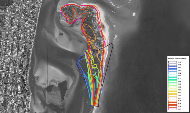
Interesting how the entrance has varied so widely, yet the breakthrough spot just got progressively thinner over the years. Great article and full report available here: https://www.qld.gov.au/__data/assets/pdf_file/0020/362342/review-causes-... (PDF, 17MB - larger, and more, images).
----------
"Report details the causes of erosion that led to a tidal breakthrough at Bribie Island."
https://www.sunshinecoastnews.com.au/2023/04/14/review-reveals-causes-of...
----------
Looks like a flathead metropolis to me
Went down and had a look recently. Ankle deep in the middle of the old bar at low tide. Walked from Happys down Bribie, around the corner at the new entrance, all the way in to the shore at Golden and barely got my feet wet. Just crazy amounts of sand IRL. Still looks terrible for surf potential though. Too much sand reaching too far out, not in a good way, reminded me of Redcliffe a bit. The old good spot is completely gone.
----------
"Traditional entrance to passage on verge of closing completely: water quality tested."
https://www.sunshinecoastnews.com.au/2023/05/11/bar-could-close-complete...
----------
Any guess what another year of the same will do to the Caloundra 'waterfront'?
Yet more sand filling the corner at Caloundra till the Coast Guard has to move south and the waterfront cafes have to find a different selling point. With no tidal movement and only intermittent inflow from creeks it's hard to see them enduring as anything more than refreshment stations before the long sandy walk to the waves.
It's still very deep down the end of Bulcock/ the boardwalk. Though from where that sand point's sticking out top right of the photo, it's not hard to imagine it completely closing off there and everything ocean side of it becoming nothing but sand or one day even bush from Bribie all the way to Happys.
Then if it blocks off north from the new entrance, maybe the entire north end will fill up with sand/bush one day. The change that's already occurred is pretty incredible. Interested to see how some El Nino years may change things too.
Pelican Waters Community Update
2022 Spring Edition
https://www.pelicanwaters.com/the-pelican-waters-community-update-spring...
Shifting Sands
Safety of recreational watercraft & Tidal Range water Quality!
2022 Summer Edition
https://www.pelicanwaters.com/pelican-waters-community-update-summer-2022/
"Protecting the Passage a top Priority!"
Concerns over water Quality at Northern end of the Passage.
Water quality could deteriorate that it becomes stagnant & uninviting!
Coast Guard can't do their job properly!
Dredging the secondary channel in our opinion is worth a try!
............................................................................
* I know what you did last Summer!
............................................................................
2023 Autumn Edition
https://www.pelicanwaters.com/pelican-waters-community-update-autumn-2023/
"Best Bar Conditions in Ages"
New Entrance to Pumicestone Passage & a more consistent navigable channel for all!
Now it's even easier to Travel to Moreton Island, Tangalooma right from your own backyard!
"Boat Options May Surprise"
Reports of 1.5m depth at New Entrance
'So is that all sorted then!' ... Like Wot!
'Is one Season too soon for a Back Flip...'
'Coz ya can actually count this back flip over a year can't ya...surely that's cool enough!'
Sure! Why not...for a Real Estate lacking remorse & compassion...guess so! (Cool!)
----------
"Dead end: bacteria concerns as bar closes."
https://www.sunshinecoastnews.com.au/2023/08/23/bar-appears-to-close-ami...
----------
Any improvements on banks to surf at all?
Without intervention it could end up similar to the Macleay Arm at Stuart’s Point, NSW North Coast with mangroves colonising the inside of the sand spit.
The Macleay River once flowed through to Grassy Head near Stuart’s Point but in the 1890’s broke through at South West Rocks near its current position. That left the former river channel the “Macleay Arm” as a dead end which is slowly infilling.

Not far off two years since Bribie Island was split, and now the former entrance to Pumicestone Passage looks like a regular straight beachie from the headland.
Here's the current view from our Caloundra Bar cam... we probably need to rename it Caloundra South!
Visited recently. There's SO MUCH SAND in real life it's crazy. The new opening is way wider than the old one too and doesn't look promising for decent surf. Interested to see how the new stretch of beach goes though. How's the trich in the passage...
https://www.sunshinecoastnews.com.au/2023/10/21/blown-away-by-the-colour...
https://www.sunshinecoastnews.com.au/2024/01/16/the-changing-faces-of-th...
High tides provide temporary breach of bar but major event needed to unblock passage entry.
Thanx Sprout and crew...deserve an award or reward...
Pays to read the local comments for further insight into this break thru.
Gonna need crew's help to access Facebook Comments to verify the reasoning.
tbb is locked out of Local Here say...but feels local banter fills in the Gaps.
Requesting if any (f) members could share the local Sunny heresay!
Sunny Whiteshoe Canal Estate breakthru conspiracy...starts up Sunny (vs) Goldie Whiteshoe War.
Fuck yer Sunny Wave Pool War > Who holds the Title of Dodgy Canal Estate Coastal Obliteration!
2nd Nov 2023 Trevor Smyth
https://www.facebook.com/photo?fbid=122121307568069071&set=pcb.122121307...
"This shot shows the Impact Pelican Waters had on the breakthru!"
2nd Nov 2023 Paul Connolly
https://www.facebook.com/photo/?fbid=122121307718069071&set=pcb.12212130...
"That Picture makes it easy to see what caused the breakthrough. More Canals equal more Water flowing across the passage as the Tide Falls!"
3rd Nov 2023 Gayle Murphy
https://www.facebook.com/photo?fbid=122121852464069071&set=a.12211231605...
"Yep! Perfect photo showing how Pelican Waters Marina & Locks System comes straight out into the passage hitting the narrow "Weak Spot" on Bribie Island and breaking it open to make the New Bar.
Not MOTHER NATURE - Development has caused havoc with our beautiful passage and closed off the Caloundra Bar!"
Ok! Can we check on this...we can give it a run...
https://www.facebook.com/pelicanwaterscaloundra/posts/pelican-waters-sho...
Sept 2020 $5.5m PWSL Lock Opening merges more South Lakes water volume each opening.
14th Dec 2020 Bribie Island Washover
https://www.sunshinecoastnews.com.au/2020/12/14/wild-weather-sunshine-co...
2nd Jan 2022 Breakthrough (swellnet feature)
1st Sept 2022 Caloundra Coastguard say they'll relocate to Pelican Waters Power Boat Club
https://www.sunshinecoastnews.com.au/2022/09/01/caloundra-coast-guard-bl...
March 2023 Caloundra Coastguard relocate large Ocean Vessel to Pelican Waters New Marina HQ
What's interesting with this theory is that it reverse-mirrors Brisbane & Tweed River sub dredging.
Estuaries are dredged beneath sea level this mass ocean exchange ramps a Micro burst Storm.
Resulting in Meteo Tsunami forging long upriver tidal surge.
Pause!
Kidz learn this by extending Sandcastle canal to invite ocean to perfectly gut & level out a full moat.
This tidal wave surge freely guts the upper River and Estuary to save a fortune on dredging.
Kinda like supercharging nature to cough it's guts up to clear it's throat & valves to free up shipping!
Massive enviro devastation but rewards are boundless for shipping!
Here the locals claim a reverse process of flooding more canals to breach back beach out to sea...
Kinda similar to Overflowing Dam release but nearer canal lock top overs have nearer ongoing direct impact.
Ramped outflow volume breaks thru the nearest weakest link to forge a direct deeper Superyacht Seaway.
This floods deeper dedicated boating channels for both Peilcan Superyachts & POB super containers!
July : Never impeded US Navy to ship tanks ashore to blow up SEQ hwys.
Too much coincidence that max Dredged Harbours keep accidentally inviting mass ocean inflow?
Coincidence that they all ramp weather devastation to gain max desired deepest shipping as a result
Also consider Port Of Brisbane control this new deeper boat channel & say nothing...
Why?
Coz it saves them dredging silted Caloundra bar N/W channel at Hamilton Patch > big turn corner.
Coincidence that both Pelican Waters & Port of Brisbane are supa stoked with new deeper Seaway!
No longer need to worry 'bout POB erosion at Bribie Is weak turn point...now a strong point! Win! Win!
Should Bribie shoreline slowly disappear to widen N/W channel...only natural isn't it? Guilt free POB.
Pelican Waters now got a massive future Silted Lagoon to reclaim for endless canal estates! Problem?
Dry docked Caloundra Coastguard just gotta go with the Flow.
tbb don't need to say the Local theory holds water...does that quite well all on itself...well, don't it!
Salute Local Knowledge...thanx for sharing Sunny!
As said...tbb knows least on this...be stoked if crew could rule it in or out with local know how!
Great stuff TBB.
https://www.sunshinecoastnews.com.au/2024/02/06/another-breakthrough-for...
"Images show where tide has overwashed another section of Bribie Island."
Just checked some historical imagery, looks like it's been breaking through there over the past two years.
just south of the lions park , my favorite part of that beach has been destroyed,
Agree! Great stuff from yer Sunny Boys to pick up on the Goldie Locks brew being just right!
Allows us brothers in arms to wade in a little deeper...we can do that here & now!
You guys keep up the fight & Goldie crew will roll out yer Whiteshoe Lockstep & Pork Barrels.
6 Feb : Sprout's King Tide { Wannabe Breakthru Drama }
Sea Rise Waves hasten the erosion of Islands & Coastlines
Sea Rise / KingTide ~ Waves Wash Over (Spoils) actually trawl over sand banks & Atolls.
When meeting an Atoll or sandbank the waves are slowed to trawl & deposit spoils on highest point.
This builds up Barrier Islands as longer less wide but larger Coastal Barrier islands...
Exactly what the News article implies...don't be fooled by ocean wash over as a new breakthru.
Basically sealing yer fate by walling yerselves in...only complete chaos will break thru...
Saltwater Morality Legends detail near all local sea rise / fall + river / ocean breakthrus.
River breakthrus are orchestrated by Snakes chasing Sparrow Hawks down mountains to sea.
Coastline Defenders are Water Rats / Turtles (Hills) with Dugong Barrier Islands guarding Rivers
Bribie / Moreton / Straddie are all Dugongs but each breakthru differs
Dolphin interact with Land Folk...Frontline Defence.
Sea Rise invaders are Gods > Serpents / Sharks / Vengeful Warriors
Bne River is by Sharks invasion (Sea breakthru) Fins cutting thru River banks (Kangaroo Point)
Moreton / Straddie is by Hawk > Rains unblocked River mouth forcing outbound breakthru of Spit.
Warrior becomes an iconic rising headland by reclaiming coastline villages as sea subsides!
Always was, always will be Aboriginal Land = Warriors grew our land (vs) Invaders are losing our land
Each moralistic tale details climatic events...as most important ancient universal natural library.
Back to modern day Sunny Local's Pelican Waters breakthru theory that's gaining momentum...
Sprout's fantastic photo share...(Thanx!)
Clearly depicts Pelican Waters continually floods out...eating at Inside weak points of Bribie Island
We assume waves are breaching the Island but all clearly see it's an inside out Break-Thru...
Again...why only ever always directly opposite new Pelican Waters harbour...huh!
Ok! tbb can provide some answers...
5th June 2020 (tbb) [ Depth of Locks ] ...continued from (Stu's Sunny Wavepool > New Hyatt Coolum)
Then tbb dredged up WSL River Lock water quality / Public access
https://www.swellnet.com/news/swellnet-dispatch/2020/05/28/sunshine-coas...
Larger S/E rivers flood a natural navigational tidal wave 1.5m draft at low tide
eg: New 'Forced' Bribie Island Breakthru is now naturally levelling out at 1.5m low tide.
SEQ dredge 2m for minimum "Open" Navigational channels / Creeks
1.3m Draft Lock height (Goldie Old School) has no impact to natural estuary.
Deficit being undesirable smaller vessels pooled in non tidal algal bloom fish kill -Stinky lake / canals.
1.5 Draft Lock height (Standard) allows tide to flush thru the system > moderate > HP Skiing vessels
2m+ Draft Lock is usually fitted well up river to extend natural inexpensive flushing for 2m navigation.
Flooding Impacts have ruled out progression of 2m depth without first raising upper Dam heights!
Seachange real estate attracts bigger fish mandating bigger luxury Game Charter Yacht Brothels.
No Blue Marlin Hunters = no record Canal Sales...got it!
With limited natural waterway navigation real estate available...
Protected Bay Bar Passages are seen as premium secondary navigational Bay Real Estate.
But Passages vary from 400mm - 1.5m max draft...(Not enough to lure Seachange Gamerz)
Q : Why then did Pelican Waters lower locks to 2m Draft knowing full well Bars max low tide at 1.5m.
Pelican Waters is not sold to Water Ski crew or Hobby Craft Day Trippers...
It's designed as a Professional Nautical Hub for Fishing Charters > Mustangs to 55ft Rivieras.
https://boatchartersydney.com.au/boats/platinum
Pontoons > House Boats > Traditional Sunny Coke Drop offs & Floating Brothels are back big time!
https://www.pelicanwaters.com/pelican-waters-community-update-spring-2023/
In short the old bar was silting up & slowing up Pelican Waters Pro Navigational Coke runners!
Extra deep 2m locks continually force flood a new 2m equal depth seaway directly out front...
That's how ya do a Coke run...(Thar she blows!)
Newbies shed a tear for Ye olde bar! Now supastoked with their direct newly forced deepening seaway!
All can accept that Govt sold off the Bay to POB...guessing this new seaway is their side order!
There does remain one or two unsolved loose end anomalies of transient land bank..
Castaway Island has no new offshore land title Claim by First Nation?
Castaway Island is clearly no longer secured or managed by Qld NP.
As such ...will fall into the hands of POB Leasing maintenance obligations.
Castaway Island has no connect to Bribie Island.
Castaway Island has no Connect to Mainland.
With that in mind...one must ask if POB have default rights to New Sand Bank.
If so then any / all future use or leasing will be exempt from Qld Laws!
So yeah! As it stands...Govt / NP don't give a shit about Suss Locks > New Seaway / POB Island!
This looks & smells like a Whiteshoe NP Land Bank grab of epic proportion...unless Wot...
Unless someone cares...as if...well durr!
Just reminding this Island lazes between every no man's land of every council / state / fed boundary!
Maybe that's exactly wot Whiteshoes are banking on...Mine Precious! POB will flip ya for it!
Not quite there yet...
This Pelican Water's Seaway may yet open much wider problems...
All see waves will start breaking on inside Golden Beach...quit droolin'!
Talking about Tax payers forking out for Wave Breaks / breakwalls / Beacons
Don't tell tbb that wasn't ever considered in the rubber stamped masterplan!
Like this Rogue Island is now a security threat that needs reelin' in...all gotta stoke up for that!
Pelicans obliterate yer Island & expect ya to provide a safe Harbour for Sunny Eastcoast Coke Runs.
thanks for sharing that tip-top 1
Got to wonderin' about NP duty and minimum NP obligation.
Here's the latest on Qld NP Ruling on (Breakaway Island)
This sounds well suss...
June 2023 - 30 Dec 2024 (Updated 30th Dec 2023)
Why is there a sunset clause expiry of 30 Dec 2024... is that significant...huh!
*NP BOUNDARY REMAINS AT HIGH TIDE MARK
* (Recreational boundary) extends down to the mean low water mark and moves with accretion and erosion of sand.
* Newly formed sandbars and vegetated dunes at this northern breakaway section fall within the (recreation area boundary)!
https://parks.des.qld.gov.au/parks/bribie-island/attractions/lions-park-...
Ok! That sounds like the breakaway Island is no longer NP Listed.
Meaning it's not protected!
Certainly not any fast growing shoreline beyond low tide..
Read that as NP may only apply to original mainland portion...
Should island be redeveloped perhaps only the original former portion remains gazetted as NP.
(Recreation Areas) : Rest Stops / Caravan Parks / Ovals / Showgrounds...etc...
Govt sell off Rest Areas > Caravan Parks...
https://data.gov.au/dataset/ds-aurin-5f9c1a03-ba00-47fb-b280-4f54dc4c6e2...
Smart local would stick a Low tide Flag on fastest growing beach...
Sit at home & watch yer Surf Resort Tax Haven grow faster than sea monkeys.
Say ya only did it to stop whiteshoes hoovering it up...donate yer island back as a bird sanctuary!
Does Govt need to regazette this New Island as NP as it's own entity or are they gonna sell it off!
Does it get sold off as all other Qld Recreational Areas.
Reckon a local would wanna ask such...is this island protected, or is it the next Whiteshoe Tax Haven
Geez that would be something TBB if Pelican have done themselves in. What's the long term fix if it punches through? New rockwall? New wedge! Bring the erosion!
looking at the above photos, its almost a guarantee it will break through again , it gets undermined from the passage side tidal flows, then the wash overs break from the ocean side, pretty identical to what happened up near the beacon .
my opinion only here of course
Another new river bar? Almost...get digging kids.
So what's changed to have the northern end of Bribie again threatening to split?
Less sand flow on the ocean side? More water on the Pumicestone side? Changing currents perhaps..?
There's a better than even chance we're going to revert to La Nina later this year, which, if it happens, will likely bring rain and persistent easterly swell. Any vulnerable areas will be tested, the kids might not need their buckets and spades.
Yeah with the coming Niña it'll be easily breached.
stunet, its always been thin in areas right up the top end , before the first break through it looked like the passage side was being eaten away by the tidal flows, then larger storm surf and swells were washing over, just my take on this,
stunet, its always been thin in areas right up the top end , before the first break through it looked like the passage side was being eaten away by the tidal flows, then larger storm surf and swells were washing over, just my take on this,
2006 Howard's Nuke Taskforce selected Bribie Island for a Nuke Reactor.
tbb is reminding how Bribie NP falls off the Map...better than being blown off the Map...Ouch!
(Burp!) 'Better quality WMD back in the Howard Era!
Obviously Qldurrz don't give a fuck if Howard or Dutto wanna Nuke wotz left of Bribie Island NP.
Pelican Waters Whiteshoe Cooling Pond + 2m lock was Bribie Nuke Plant pressure valve...well durr!
NP : National Park > (Howard's Way) > NP : [X X] = [ Nuclear Plant ] Better!
Weekend Time Machine...recalls when a free trip to the moon was a core promise! WOTD..../(C`..[Yew!) * ** ( ' ' )
Don't cry Sprout...Goodvibes won the Sunny Coast NWSR H-Type contract
https://australiainstitute.org.au/wp-content/uploads/2020/12/Nuclear-sit...
Just reminding it takes little time & cost to raise the 2m Lock > 1.5m (Bar depth)
IOU : 'Couple of XXXX Slabs!'
Then drop the Big Game Hunter's Canal Block prices by half & market it to Pro Wake Boarderz....err...No!
Shitshow should then flow as one with passage tides to alleviate or slow Bribie erosion...sorted!
Guessing Sunny Whiteshoes wanna ransom a free breakwall / Wavebreak as #1 Election Issue!
Save the Town win the seat - slot in the Nukes....(Please Stop tbb...gonna puke...already beat ya to it!)
Just waiting for their VIP Coast Guard guests to sign here [X] + here...[X] Here's yer Lock Code...'Free!'
Capt: 'Shifty Bribie Seaway is a trip hazard, needs a training wall...Now!...or before next State Election!'
Both Parties will brawl to bankroll #1 Sunny Coke Traffickers Route sooner than fix Ye olde Tinnie bar!
Gets any deeper & wider > be able to swing a Princess about in there...forget tbb said that!
Bribie is good enough port'o'call for Lady Brisbane...
Be a splendid Voyage this one...not just saying that!
https://www.australiancruisegroup.com.au/brisbane/brisbane-river-cruises...
tbb cruised The Lady Brisbane from Gold Coast Spit thru the Bay up Brizzie River to Hamilton Wharf.
{ 300 Island Cruise } 8hrs...Plenty of Tucker & Cuppas + Authentic jovial interactive Historical Tales!
Backtracks 1864 Brizzo Robert Herbert's Main Beach Bodysurf Safari Crew ...Totally Wild Nostalgic Surf Safari!
Real good for ya to eat the waves said Robbo...think the crew are on his wavelength...all love eating waves!
Happy to cruise with this crew anytime...Mum usually pikes out on ships...stoked she was!
Ripper of a family day out...no worries! Good as Rolled Gold...just soakin' it up...life's a breeze!
https://www.australiancruisegroup.com.au/gold-coast/surfers-paradise-cru...
Highly recommended for Locals and Visitors...breathtaking journey...must see & do!
That price went up a bit...still good value...should get a better deal if ya shop about...shall we!
https://brisbanecruises.rezdy.com/55973/gold-coast-to-brisbane-300-islan...
Lil' beauty...let's try again...see how we go!
https://www.brisbanecruises.com.au/specials.html
Howzat!...on a roll...save $10 or more with each click...have a crack!
Only runs on Spring Tides...last of an era...get on board before another dream boat vanishes!
Qldurrz dedicate this comment to inquiring Southern crews.
Thought we could share a closer examination + more Oz security insight.
Bribie is back in the news for Oz security reasons...Nuke Plant.
tbb was quite surprised by [L] connect to Bribie Nukes! Is this a thing?
First we can share 2 Excellent News Articles on these 2 Wash Over sites
End Jan (King Tides-Cyclone) early Feb 2024
New Bar is now 1.2km wide
Drone inspection of Dual Wash-over Locations south of Main Break Thru.
These are close up shots of the areas the crew (above) were predicting to breach.
There have been several similar wash-overs of these zones since 2008 > 2017
https://www.sunshinecoastnews.com.au/2024/02/06/another-breakthrough-for...
Next news article captures these (High Tide) wash-overs
2.1m Tide + Surge maxed out @ 2.4m > (Seth's Big break Thru was 2.1m > Surge of 2.6m)
Crew also spoke of Golden Beach being swamped...
Swamped Military Jetty throats the Pelican Lock is not near either bar
Golden Beach Tides now at 2041 Predicted Levels
MSQ updated HAT by 310mm
More Water coming in over the bar than going out!
None accessed the New Bar during cyclonic weather
https://www.sunshinecoastnews.com.au/2024/03/15/twenty-years-early-subur...
Seems like there were approx 3 wash overs at each site during Jan / Feb 2024 Storm Tides
Very close to breakthru's > Mid winter Low or Next Summer will threaten again...
Let's be honest here...all things being equal it's pretty hard to argue it's not the lock.
Soon the whole shebang centres and gauges same depth as Mankind's Lock & POB Turning circle.
Which obviously leads to Securing a massive Port Sized Cash Splash Clash .
We're talking a lot more than occasional dredging of the old Bar.
Reckon we're looking at Oz biggest backers & Players.
The two biggest in the news are Port of Brisbane & Aukus
(Both deal in $Billions) & Both would love to secure this Berth at Head of Port of Brisbane!
Fort Bribie > massive ships.
1911 Koopa 1153 Pass (Orchestra / Casino)
1920's SS Doomba 1500 Pass
1942 Both Ships served in Bribie Royal Navy
Fort Bribie Naval Installation/s
1946-53 Koopa returned to Bribie cruises 1946-1953
Q: Is Fort Bribie still secured by Govt...because [L] targets Bribie for a Nuke Plant
Q: Are Sand Islands designated as Highly Radio Active Zones? > Nuclear Medicine Suppliers!
Got an icky feeling this Island is set to again play a Security Role for strategic reasons.
https://www.world-nuclear.org/information-library/safety-and-security/ra...
Damn...it's a loose link...but it does localize the importance to Nuclear Industry...
Otherwise load these...
https://www.ga.gov.au/education/minerals-energy/australian-mineral-facts...
https://www.ga.gov.au/scientific-topics/minerals/mineral-resources-and-a...
1972 PM McMahon & Joh's Nuke Plant Toorbul Point / Bribie was ruled out by Gough!
https://www.smh.com.au/national/johs-secret-70s-dream-a-nuke-plant-20030...
2007 Howard's Nuke Plant on Bribie Island was ruled out by Albo & Peter Garrett
https://www.brisbanetimes.com.au/national/queensland/alp-ad-blitz-names-...
https://www.couriermail.com.au/news/queensland/sunshine-coast/hand-on-he...
2018 LNP State Conference did not rule out Bribie Island Nuke Plant
https://www.parliament.qld.gov.au/Work-of-the-Assembly/Petitions/Petitio...
Is Dutto pushing for Bribie Nuke Aukus Sub Base!
May 2020 Nuke Free Bribie [No LNP Nukes Here]
So that's not exactly a new site & it's pretty solid with content.
tbb had no idea that Bribie is an ongoing [L] Nuke Quest...
https://www.facebook.com/nuclearfreebribie/
Fort Bribie eerily has 34 servicemen...
Is Bribie still under Defence Contract!
Could ADF secure a renewed Aukus Nuke installation here!
Anyhow...tbb thought it was important to not rule out Bigger Fish.
We could be dealing with a Frontline Security Hub...explains the perceived Govt apathy!
Once again consider this site falls between all duristrictions...easy Target for Govt Exploitation.
Oof.
----------
Study warns of erosion, flooding as waves compound storm tides.
"Anywhere with an average sea level height less than 4.7m, or within 200m of the Golden Beach Esplanade, should be considered within the wave zone, and buildings within the wave areas should be built to endure the wave forces."
https://www.sunshinecoastnews.com.au/2024/10/25/tide-study-says-passage-...
----------
Some more info Sprout, I live within 200m of the golden beach foreshore, just spent half a mill renovating our old house, any new build or renovation over 20 square metres needs to meet new flood guidelines which predict the water level in 100 years, that water level is more or less 500mm above most of the existing homes in golden beach, scary when you have to lift your entire block by half a metre! I hope my kids get to enjoy it!
That's full on hey, crazy to think about half a metre of water over that entire area!
Painful but the Q100 is pretty standard and not unique to Golden Beach. You're lucky its only 500mm above the existing block level as some blocks in Palmy are up to 1.3m below the new Q100!
Gold Coast also make you consider the PMF (Probable Maximum Flood - i.e noahs ark 1 into 5000 year flood) and require you to build 2 storey homes so there is 'shelter in place' when the biblical flood arrives and washes away everything on your ground floor- crazy!
King tides and cyclone swell, another break inbound...
----------
https://www.sunshinecoastnews.com.au/2025/02/27/catastrophic-risk-to-sub...
----------
Wow!
Some great photos and videos from Bluey's photography.
https://www.facebook.com/blueyspix/
Old bar washing over.

New bar hole getting bigger.

Coming soon bar.

just down from lions park, been pretty thin there for a fair while ,
the tidal movements around that area have always been quite dominant,
will be barreling into bells creek before we know it
Cyclone Alfred Splits Seth Island, with Newer improved more permanent parallel Channel...Oopsie!
Sorry 'bout the cheap upgrade Stu...local crew are under the pump > racing ahead for next breakthru!
New foot deeper Lock split the Island + added a foot to the tide > [L] Pulled The Sand Back Pass
Then Double triple swamped Bribie Island with 3 Dam Releases Now gotta 1.65m Storm Surge...
Now run outta Sand Dunes + Beaches + Sand + Sandbags = Double Triple Ooch!
Joh / Howard / Dutto campaigned for a Bribie NUKE Plant or Fleet of anchored Bribie Nuke Subs. (Same Thing)
Since election [L] Genius Davy pulled the Bribie Sand Pump Pipes...then Flooded the Island 3x...
1.65m Storm Surge & thar she blows = New Aukus [Port] for Trump !
Please do not jump on any more sandcastles...
https://www.facebook.com/couriermail/videos/premier-david-crisafulli-sai...
&t=2shttps://www.facebook.com/thesunshinecoastdaily/videos/%EF%B8%8F-the-firs...
https://www.sunshinecoastnews.com.au/2025/03/04/island-protection-dimini... &t=7s
https://www.sunshinecoastnews.com.au/2025/03/05/water-inches-closer-as-i...
Incredible, and not much holding back the next incursion either.
...aaand it's through.
Ocean flows through section of island, even at low tide.
https://www.sunshinecoastnews.com.au/2025/04/08/flow-and-behold-new-spli...
"Flow and behold..."
Chortle, chortle.
So that breakthrough is south of the picnic area and toilet block on Bribie? (Lions Park?)
If it is, and if it expands to become the major entrance between Pumicestone and the ocean, then the canals of Pelican Waters are at risk of being silted off.
Can see already what's happened to the section of north Golden Beach up to Bulcock Beach.
Yep, going to be an interesting few years of sand movement.
Could be a good time to start a yabbie pump side hustle.
Few more photos from the most recent breakthrough. Much commentary wondering whether this means the northern channel will silt up and, if it does, what that will mean for Golden Beach:
Banks
Nice.
Wonder who got it first, is it worthy of a proper name? Probably gone in a season.
Some cool before/after sliders of the whole coast post Alfred. The cliff at Curras is 15ft vertical drop, lots of big trees fallen.
https://www.sunshinecoastnews.com.au/2025/05/01/imagery-shows-how-alfred...
Old mates clip before that one ^^ shows the third breakthrough is about to go.
?feature=sharedNot easy to see how this is gonna play out.
After the first breakthrough, QLD's Department of Environment and Science issued a report finding problems with sand infill - the Coastguard at Caloundra was now cut off from the ocean - and water quality issues due to reduced flow through. Since then there's been another major breach, and as that video shows a minor one too.
Would be curious to read an updated report. Hard to imagine all three openings joining up; there's no precedent for a kilometre-wide tidal delta. More likely would be the outflow merging into one major bar, and as the new breakthroughs are appearing to the south, it'd be the southern-most one.
If that happens then the Golden Beach/Pelican Waters canals could go the same way as the Coastguard: Silted up and cut off from open water.
EDIT: New review currently in progress.
It’s amazing to see in person after only ever knowing how it was before the first breakthrough.
The third breach is at the very bottom of the thin spit? that was the northern end of Bribie. The island gets considerably wider to its south so no more breaches I’d say so I think you’re right about the southern one becoming the dominant bar. (once established)
ps. It’s to the south of the Pelican Waters entrance so I think silting up, as you say, in the canals is definitely on the cards.
https://www.sunshinecoastnews.com.au/2025/05/16/landmark-park-and-hut-wi...
-----
Bribie Island breakthrough may close as sand banks reshape waterway
https://www.sunshinecoastnews.com.au/2025/06/06/prominent-tidal-breakthr...
-----
Some spectacular Bribie update Vids / Pics there crew...thanx for sharing.
tbb feels as majestic as it may be... it lacks context in no mans land.
Crew may be aware of companion State Govt Review/s & Now current Urgent News on the matter!
Just sharing that despite seemingly lack of interest > there are major plans afoot and in play!
That's the whole point of drafting and sharing this update...because it's fast becoming urgent news!
From a Local Qldurrz perspective...then Yes! We gotta get up to speed & expect a shock of sorts!
There is a Fed / State Govt Style / POB Takeover Solution.
(Part 1) Process of Exemption
Important to state up front...
The breakthrough Channel in Question is a transient body that exists in no mans land.
Situated between & changing shape of entity changes it's geographical jurisdiction...
Yes! This Majestic Breakthru morphs several Council / State / Fed Electorates < > Reserve Status.
All of which is changing as swellnet crew record & exhibit...
Meaning the Terms of Reference...
Are more likely modelled to exempt whichever Govt Body conducts their Whiteshoe Review
6 Feb 2023 BMT Review of Causes of Northern Bribie Island Erosion
https://www.qld.gov.au/__data/assets/pdf_file/0020/362342/review-causes-...
+
Aug 2023 BMT POB Channel Enhancement Statement
https://www.statedevelopment.qld.gov.au/__data/assets/pdf_file/0031/9592...
Nov 2024 / N/W Channel Map dated Feb 2024
https://www.publications.qld.gov.au/dataset/brisbane-port-procedures-and...
Nov 2024 NP Maps
https://parks.desi.qld.gov.au/parks/bribie-island/maps-resources
These Last Govt Maps are shared because tbb can't find or access any New Govt upgrades...Ok!
.....................................................................................................................................................................................................................................................
March / April New Govt LNP Reviews
March 2025 BMT Fact Sheet 2
file:///C:/Users/Owner/Downloads/POB_Channel%20Development%20Project_Capital%20Works_Factsheet_Jan%202025_v4.pdf
March / April 2025
Public Consultation for Bribie Island Erosion and Breakthrough Review
Conducted by ICM / RPS
https://www.coastalmanagement.com.au/
https://www.rpsgroup.com/services/oceans-and-coastal
Prepared for ...
Qld Govt Dept of "State Development, Infrastructure and Planning"
(See Dept)...reminding the review is not focused on NP Preservation
see also former Govt BMT Review in conjunction with POB Channel Enhancement.
tbb is not picking sides or Playing politics...
Just informing that any Bribie Erosion Review clears the way for reciprocal Moreton Bay Development.
Kinda massages any following Developmental EPA process by stealth.
April : Terms of Reference (Are therefore Incredibly restricted to contrive relative outcome!)
https://www.statedevelopment.qld.gov.au/__data/assets/pdf_file/0005/1000...
14th May 2024 Bribie Island Erosion and Breakthrough
"Independent Expert Review Pursuant to The Terms Of Reference"
https://www.statedevelopment.qld.gov.au/__data/assets/pdf_file/0004/1010...
Review of the [ "Causes of Northern Bribie Island Erosion" ]
Again read here of (Development Dept rubber-stamping an Exemption)
* Dredging of the Nearshore and Offshore Areas were Dismissed as a Contributing Factor due to...
A Lack of Supporting Evidence
........................................................................................................................................................................................................................................
A lack of Supporting Evidence
*Sunny Game Hunter's South Lake > floods an extra 300mm into LC / Pumicestone Passage
https://www.pelicanwaters.com/wp-content/uploads/2021/07/Pelican-Waters-...
https://www.pelicanwaters.com/wp-content/uploads/2021/07/Southern-Lake-M...
15 March 2025 Sunny Coast Council
Maritime Safety Qld added 310mm to Pumicestone Passage highest tide range...
Perfectly times with adjacent extra 300mm South Lakes release/s directly opposite breakthru/s.
Although we're not meant to talk about the Whiteshoe Elephant fountain flooding Pumicestone Passage
https://www.sunshinecoast.qld.gov.au/council/planning-and-projects/counc...
https://www.sunshinecoastnews.com.au/2024/03/15/twenty-years-early-subur...
Plenty more off limits 'Lack of Supporting Evidence' ~ taboo topics
*Record Moreton Bay Acidic 25 meds 53 Pesticides contamination killing off Shoreline Vegetation
https://moretonbayfoundation.org/new-contaminant-study-finds-brisbane-ri...
*Record SEQ Rainfall Events +
Record SEQ Bribie Island Massive delayed Black / Groundwater Release
https://www.moretonbay.qld.gov.au/files/assets/public/v/1/services/rates...
*Record endless Summer SEQ Dam Releases during record rainfall events
Record Rivers / Bay Flushing / Volume / Flow speed > Sandbank alterations
Record Govt orchestrated Siltation of Surrounding Bay
*Record Beach Vehicle Permits during Peak Beach / Rain-Flooding-Tidal-Surge Erosion )
Oscar also touches on this in Companion Terms of Reference Review
https://www.oscar.org.au/wp-content/uploads/2025/05/Response-to-SG-re-Br...
*Record M Bay Whale Stay Med Hub - Massive continuous Sandbank interaction > Alteration
https://www.frontiersin.org/journals/marine-science/articles/10.3389/fma...
*New Govt's abrupt Halting continuous South Sand Dredging > North Beach Pumping
Part 2 Continues with Peoples Consultation + Urgent Outcome
(Part 2) Bribie Breakthrough Review
Peoples response + Urgent Outcome
https://statements.qld.gov.au/statements/102231
24th March News Report of Public Consult but no link as yet..
https://www.sunshinecoastnews.com.au/2025/03/24/review-of-island-breakth...
Starts with POB CEO courting MP about Bribie Island!
2 April LNP Caloundra MP meets with POB CEO to seriously Map out Mid Bribie shallows Project
https://www.facebook.com/photo/?fbid=122232775796081177&set=a.1221556846...
https://www.facebook.com/photo/?fbid=122232775808081177&set=a.1221556846...
https://www.facebook.com/photo/?fbid=122232775826081177&set=a.1221556846...
Ok! tbb recently reviewed M Bay...
If State Govt want an 'Urgent fix' they'll exploit POB Channel Enhancement
NW Channel is expected to be the first dredged channel ( Right near this new Island Breach)
March POB Fact Sheet 2 (State / Comm Controlled Project = Aukus Subs etc...)
So eitherway > Bribie Dredging is happening very soon...( Davy can claim he's bossing it!) Ok!
file:///C:/Users/Owner/Downloads/POB_Channel%20Development%20Project_Capital%20Works_Factsheet_Jan%202025_v4.pdf
It's also a Whales / Calving bay
It is possible POB are concerned increased Shipping / Whales result in more collisions
Possibly these larger POB vessels are bumping & wounding the Whales.
Bribie Island Dead Whales
29 Oct 2006 / 4 June 2009 (2x Bay Is Mid Aug 2014 / Aug 2016 /Sept 2018 / 6 June / 31 July /19 Sept /10 Oct 2024
Many wash up on North Straddie & Moreton Islands also
Some Reports of deep Propeller gashes to Head...
But 4 last season indicates more Bay collisions in coming years towards Hosting 2032 Olympics!
Add to that the Bookend Shark Net Entanglements on Both Coasts + Air Show Bombardment...
Can expect a Whale Death / Drama each week during Olympic Year Migration.
Eitherway one must assume Whale Havens are central to Bribie Erosion remediation.
Yes POB do include these Whale Maps in future Planning.
There is another Player so to Speak...
Deputy Minister involved is jointly plugging DP World at Port of Brisbane
https://www.dpworld.com/australia
They are being courted by LNP So ya can't discount some incorporated Overflow growth facility.
But also expansion of premium Caloundra Whiteshoe projects South?
Recapping the Intro ...Fed / State are dredging Bribie Surfside very soon & State will claim progress!
So it's not a big deal to see LNP pushing for Urgent outcome > since they stopped dredging last year!
So obviously...locking in POB dredging bosses & triggers Public engagement under one EPA umbrella!
Early April rubberstamp POB N/W Dredging to pump onto Bribie Shoreline (As a cheap solution)
Explains why LNP ripped up Bribie Beach Sand Back Pass as it will soon be buried deeper...Got it!
11 April LNP Govt Video Deputy Premier / MP Terms of Reference
https://www.facebook.com/KendallMortonMP/videos/-breaking-news-breaking-...
So now we move onto hastily declared Bribie Erosion Study & Fix.
17th April -18th May 2025 " Local Residents Consultation Period (Gazetted)
29th April (12 days pass) > [LNP] Member " Intentionally stalls Community Invite > Consultation"
https://kendallmorton.com.au/bribie-island-breakthrough-review-community...
30th April (13 days pass) Stranded critters on Isolated Island? Has a link to Consult Page.
Uni experts talk of Wildlife tragedy...
tbb reminds that every Oz critter can swim better than Humans > we being most at risk!
https://www.abc.net.au/news/2025-04-30/community-worry-wildlife-on-bribi...
7th May MP News Report hints about a Review but makes no Public link to Submissions
https://www.theguardian.com/australia-news/2025/may/07/sunshine-coast-re...
13th May (26 days pass ) Stalling {f} Submissions Invite (MP Says: Hurry...Less than a week to Go...)
https://www.facebook.com/photo/?fbid=122242063850081177&set=a.1221556846...
Q : Why POB CEO MP meet to discuss Shallow Water Mid Bribie Island (Despite no relevance)
Q : Why does Local MP intentionally delay Community Submissions Twice...
(Phase 1) Local Residents Consultation
Despite Local LNP MP Censoring 84% of Public Submission Access
The 5 day (16%) Social Media Consult still received 1,200 submissions.
https://statements.qld.gov.au/statements/102412
https://haveyoursay.statedevelopment.qld.gov.au/bribie-island-erosion-an...
Notes (Update)
* 1,200 Submissions
* Potential impacts of Storm Surge
* Enviro impacts of Bribie Breakthrus
* Effects on Local Infrastructure / Homes / Parks / Roads
21 May 200m long seawall Golden Beach Shoreline (Tested by Manly Hydraulics Lab)
Early Dec Completion
4th June Homepage (Update)
https://www.statedevelopment.qld.gov.au/infrastructure/projects-and-prog....
4th June (News) Bribie Island Review zeroes in on Urgent Action
https://statements.qld.gov.au/statements/102667
* Shift Focus from ALP Do Nothing to Urgent and meaningful action.
* Solutions and Options Immediate Remediation
* Local's Views will directly shape the next stages of the Review
Ok...if that sounds suss then check reference to partners...Indy Experts / SCC / Caloundra MP K. Morton.
Morton : " Focusing on urgent actions for outcomes...not just another review that gathers dust.
https://www.brisbanetimes.com.au/national/queensland/bribie-island-repor...
Deputy Premier focuses on Aug Review Finish with Safe Premium Boating Access above all.
[Factcheck] Talk of former Govt Doing nothing...Maps were last updated by former Govt n Nov 2024
From (Part 1)
Feb 2024 North West Channel Map
https://www.publications.qld.gov.au/dataset/brisbane-port-procedures-and...
Nov 2024 ALP Govt is the only Current Bribie Island Map still in use...
https://parks.des.qld.gov.au/__data/assets/pdf_file/0028/163297/bribie-i...
tbb would love to share any updated Bribie Island Map produced by LNP
Instead they & we gotta rely on these dusty ALP ones...
Govt : Sand Dredging / Pumping has Zero link to Erosion but somehow will miraculously fix it?
Consider every Bribie Erosion report has ruled out canals / dredging / pumping having any impact....
For last 50 years [LNP] proposed remediation has been their Bribie Island Nuke Plant
[LNP] Nuke Defence Utility fixation lends to an Aukus Nuke Sub / Game Fishers compliant Seaway.
No! That's not funny...but it ticks [LNP] Ideal Olympic Nuke Port with Crocs guarding the entrance!
Does that sound urgent enough?
Eitherway POB will be central to bossing their urgent Bribie Dredge / Pump project with or without LNP.
Looks like LNP are simply blurring the lines to claim Bribie Sand Solution that was POB long approved.
Just humour them...give them a pat on the back...
Anyhow...you'd think this Urgent LNP Govt Action might need their own Bribie Island Map.
Crew are urgently seeking an updated dust free Dec 2024 - June 2025 Bribie Island Map! If one exists?
Not that it really matters coz there is no real hurry after all is there...thought not!
council/ state gov are about to start dredging the banksia beach canal due to silt build up etc , water clarity is pretty good atm considering the amount of rain we've had
Dux creek?
freeride , yep formally known as
tip-top1 > Banksia Beach Dredging > 80,000m3 Spoils ( Pacific Harbour / General Rates)
Cr Brooke Savige
https://www.moretonbay.qld.gov.au/Services/Projects/Environmental/Pacifi...
https://www.facebook.com/Savige4Div1/posts/pacific-harbour-dredging-proj...
https://www.moretonbay.qld.gov.au/Services/Projects/Environmental/Dredge...
...............................................................................................................................................................................................................................
+ (Recap from above > Alt 2025 POB Channel Enhancement links)
Aug 2025 Urgent Bribie Review End ~ Timetables with start of POB Channel Enhancement Project
https://www.sunshinecoastnews.com.au/2024/12/06/proposal-to-widen-and-de...
Moreton Bay Dredging 75kms x 300m x 15m deep / 96.5m cubic metres over 25 years
Bribie Island Community : "96.5m3 is Enough to Cover / Raise Bribie Island in 70cm of sand.
Yes! Enhanced Patching up of the Island Breaches is discussed by Community!
Most would relate the two projects being 2 sides of same coin.
https://www.facebook.com/groups/BribieIsland/posts/5017318845160828/
That buys about 100 years for Bribie 4WDs to wear that lot down.
Likely need more than that to bury the Brain Dented Hacked up Moreton Bay Whales
Turtles will wear themselves out if they dump HM slurry along Moreton Beaches
POB Dredge M Bay Sand Shipment cost to Gold Coast
* POB 150kms / 20hrs > Palm Beach Total 60,000 T Reef Rocks
* POB 50kms / 7hr return Drops > Mooloolaba Beach (2,900m3 x 3/Loads day) 40,000m3 Trial
Gold Coast Cyclone Alfred
15kms x 80m x 6m deep / 6m cubic metres over 3 years
Cost $30m dredging + $20m Utilities = $10 Rate Payers Cyclone Levy
tbb
that holding yard where they will dump the spoil , used to be a prawn farm facility , a number of years ago,
Check the clip with Gerald Stone at the bottom of the article. The song remains the same- except TV is now colour. https://www.abc.net.au/news/2025-06-08/gold-coast-beach-erosion-manageme...
Today's Urgent Bribie Breakthrough News...continues with Fast Tracking
( Temporary Project Aims / Cost & Sand Volumes + envisaged Project Period !)
Contractors / Start Date revealed Soon.
https://www.sunshinecoastnews.com.au/2025/06/12/urgent-20m-package-unvei...
Mitigate ongoing Foreshore Damage / Improve Water Quality / Navigational Safety
Bleijie : "Dredge Baby Dredge!" (Was shouted out in Parliament today!)
There were TV news features to run with this...
(Urgent dredging Contract awarded soon > to coincide with...)
* Increasing Moreton Bay record Whale Strike doping Season.
* Increasing Record Oz Xmas Cargo Shipping Period
* Record Cruise shipping
* Port Expansion
* May-Dec Golden Beach Foreshore Wall works
* July > Dec (Onward) Dredge Pumicestone-Caloundra Passage
* Aug POB Suction Dredging N/W Channel > Spoils > 10km to adjacent N/E Deepwater DMPA
($3.5b / Consideration will be given to how POB > Reuse Dredge Spoils > Maintenance!)
https://www.statedevelopment.qld.gov.au/coordinator-general/assessments-...
Pages 11-13 ( Re-use Dredged Material )
* Form protective Sand Bank inside break thru 1 to reduce wave energy entering the passage.
* Fill Island Breakthroughs / Dunes / Beaches
* Aug Review End >
$20m Emergency Intervention dredge > Pump 100,000 cubic metres required to fill breakthroughs 2/3
Temp Channel Works
Review will consider longer term solutions...
No mention as yet of any shared POB Project Contracts / Costs
As said tbb noted Early April > Councilor met with POB CEO (Studying Maps of Mid Bribie Island)
23 May 2025 First Nation Concerns...(Moreton Bay Massive Shipping Channel Project)
https://www.abc.net.au/news/2025-05-23/qld-port-of-brisbane-allegation-f...
Woooow. Too little too late?
Yer right there Sprout...thanx for noticing & pulling us up on that...good call!
If others care tbb will likewise give a shit...
tbb made a point of saying we 'urgently' needed to get onto this ASAP.
Yes! Vids / Photos are Majestic but Govt are urgently fast tracking & shifting Goalposts...
Sure we are all well aware but we was / is playing catch up...not entirely our fault!
* tbb shared Govt were Urgently moving ahead
* Outing State Govt / Media withholding Consult info.
* Sharing Govt outcomes before Consult is even considered
* Sharing Quandamooka not being consulted
* Govt cancel Enviro Defence to Quandamooka
* Govt Olympic Fast Tracking
* Also raising awareness of Peak Dredging / Shipping (vs) Whale Season...
Not for political point scoring...
More to the point this deliberate fastracking by intent.
Sure...it might not seem like news to many of us town folk but local Quandamooka got a right to know!
Also highlighted [LNP] deliberately froze out 84% of consult...coz it was a typical deliberate LNP ploy.
Can see here why & what tbb is sharing about this Govt Urgency...
Sure...we all here kinda know this has been happening behind the scenes & more than what tbb shares.
Simply trying to catch up & take stock...game is changing fast!
Here's a recap...was actually trying to track the recent EPA override...that went thru real silent & fast!
https://www.abc.net.au/news/2025-05-15/environmental-defenders-office-fu...
https://www.queenslandconservation.org.au/crisafulli_breaks_environment_...
https://bplanned.com.au/blog/queensland-fast-track-development-strategy/
https://theconversation.com/the-fast-tracking-of-brisbanes-olympic-infra...
https://documents.parliament.qld.gov.au/com/SDIWC-1AF9/PSICBOLAB2-E1FE/s...
Good view of the third break through.
?feature=sharedStill silted up so to speak. I think this one will become the main channel if it cops a few swell events by the end of next summer. It’s right at the bottom of the old spit and the island widens right out east to west south of there.
Eddie would go
https://www.abc.net.au/news/2025-06-19/eddie-echidna-released-after-swim...
Eddie the legend R68! Good news story.
?feature=sharedThe dirty turd has established the new and I’d say new entrance.
Haha bestest red wine writing above.
..and stone's ginger wine. coopers and a satisfying schnitty! haha, travel well, brother : )
Indeed! Gave it a nudge.
What I was trying to say is that the 3rd breakthrough is now well established and I’d dare say it’ll be the main bar.
See how long this $20 million temporary fix lasts.
----------
Funding announced to pump sand into breakthroughs and create channel.
https://www.sunshinecoastnews.com.au/2025/06/12/urgent-20m-package-unvei...
----------
What a waste of money!
Bluey showing the width of the original breakthrough.
Thanks Stu...Yes! It's a great Video...
Notice ya can't Pause the Vid for a clear view at any preferred feature...
Has no speed feature to slow it down either...bummer!
Hot Tip...click the {f} Link lower right...Ok!
Now yer in {f} Click Full Screen or not but you'll find it pauses fine...no Blocks.
Now ya can inspect whatever feature yer examining...All good!
Gets weirder...the soundtrack don't play or pause on {f} Only YouTube.
Seems like it was posted on facebook > Sound Mix added on YouTube.
Perhaps that Sound Overlay mutes YouTube function or the like!
Dunno if it's a new {f} Youtube Channel starting up?
Some Social Media gets transferred from Insta -YouTube this way as well.
Usually with some setback...
Beautiful scenery.
Looks like the old bar is completely closed now.
28th Oct-25th Nov 2024 CHAPP Coastal Hazard Adaption Precinct Planning
Golden Beach-Caloundra-Bullock Beach (Includes Pummicestone Passage Dredging)
https://haveyoursay.sunshinecoast.qld.gov.au/chapps/coastal-hazard-adapt...
This Consult / Outcome > Kinda got buried...between all Councils / State / Fed Election Periods.
Importantly explains why money was allocated to Commence Dredging & Seawall Construction
Local Overview
* Engagement Study
* Info Sheet
[Fact Sheets] are just General Guides to ongoing process (No Local Data!)
Some of these Project Links were or are now Locked out or Frozen...
Thankfully we can still salvage them.
https://www.sunshinecoast.qld.gov.au/council/planning-and-projects/counc...
https://www.sunshinecoast.qld.gov.au/council/planning-and-projects/counc...
The next 3 won't load...so tbb rounded up the Main Page to Tick off them missing links...(Sorted!)
https://www.sunshinecoast.qld.gov.au/environment/rivers-and-coast/coasta...
Bonus Dredging Today! ( Provides Updates on Above Projects...pretty cool huh!)
https://www.dredgingtoday.com/2025/04/04/sunshine-coast-council-consider...
https://www.dredgingtoday.com/2025/04/29/dredging-and-beach-nourishment-...
https://www.dredgingtoday.com/2025/06/13/maroochydore-beach-replenishmen...
Ok! That's Better...that brings us up to speed with associated Mix Govt Mainland Dredging / Reclamation.
Apologize for the earlier scant links to Golden Beach Wall Works...
Kinda presented as dodgy Big Game Hunters Shark Tank overspill that flooded out the locals...
Council convinces locals they need a high'n'dry jogging track...gotta pay to keep the big boys afloat!
So now we got the Consult > Dredge Dates > Foreshore Works...all good...Yew!
"A Bold $20m / 100,000m3 Emergency Intervention"
(That should read ACCC Whiteshoe Rorting Amber Level Emergency Intervention!)
No wonder they wanna rush that thru...before Review wraps up...smells awfully fishy!
Crew : "What a waste of Money!"
Ok! tbb agrees with that...We're not mugs!
Not promising...but that quote sounds mighty steep...possibly check & get back on that..
Can share that the 100,000m3 Limit drives down the permit price...from $23,500 > $10,000
Also share that these Dredge Contracts are Hush Hush...usually appear once in a 200 page PDF!
Was after some Goldie Quotes...not often shared...
Can share NSW/SA/Scotland (2021-23) similar dredge Quotes are well under that.
Also how another operator can move in on POB turf...unless they alone are rorting this.
Not heard of any Contractors involved as yet!
Just reminding that Port of Brisbane bossed all Bribie Dredger operations...
And all saw Local MP up at the Port with Deputy Premier & X marked the Spot on these Maps.
Anyhow...that's not how ya call a spade a spade & that's not wot ya do in a sandbucket tbb...WTF.
Sure sounds like locals are footing the bill for Sunny's Big Game Hunter's over the top Shark Tank.
----------
The state government is fast-tracking $20 million of emergency works for the Bribie Island breakthrough.
https://www.sunshinecoastnews.com.au/2025/07/30/20m-emergency-works-fast...
----------
Today News Blog + Vid = Bleijie : "Dredge Baby Dredge!"
Today : LNP $180m Sovereign Industry Development Fund
*Defence *Bio Fuels *Bio Medical
https://www.facebook.com/reel/718383184519585
"Build Baby Build"
No #@*% Idea what this dude is on about...
Build Wot?
*Salt Mine *Nuke Plant *White Shoe Resort
Goes on about it in the Bribie Vid...
No more Dredge Baby Dredge! > Build Baby Build!
CSIRO operate on The Island & all that WWII is scattered & central to any redo.
Kinda thinking...LNP WWII / Pearl Harbour Salt Mine Boot Camp Resort...(Mangled on the Triangles)
https://www.facebook.com/7NEWSSC/videos/state-government-fast-tracks-bri...
Today : Govt Review
https://www.statedevelopment.qld.gov.au/infrastructure/projects-and-prog...
Tonight's Meeting
https://www.eventbrite.com.au/e/update-bribie-island-erosion-and-breakth...
Submissions Ends 17th Aug (Have Your Say)
https://haveyoursay.statedevelopment.qld.gov.au/bribie-island-erosion-an...
I'd like to thank the plant kingdom that held back the tides for some small bit of geological time. Well done indeed.
Talk now of rebuilding the whole northern tip like before Seth with old passage re established.
Rosanna on the local radio ABC this morning.
Thanx for the upgrades seeds...
Oh Swell yer making too much sense...
There is a bit written on vegetation being washed over + Gradual Passage sea grass decline.
Keep'm coming crew...
Does NP gotta replant vegetation...to new tidal line...think it's in the next rehab phase
Coz few to none mention knitting it back together...then where is talk of this massive NP Nursery?
Gotta think there is a side project that bulldozes Mangroves & Dunes to relocate to here as a live gig?
Would they be sourcing Plant growth from...
Pacific Harbour maintenance dredging, Bribie Island
Council is undertaking maintenance dredging within the Pacific Harbour Canal Estate, Banksia Beach.
* [ Project involves the removal of approximately 80,000 cubic metres of sediment from the canal. ]
It will be transported, placed and treated at Council’s [ Dredged Material Management Facility ]
https://www.moretonbay.qld.gov.au/Services/Projects/Environmental/Pacifi...
https://www.dredgingtoday.com/2025/07/25/pacific-harbour-dredging-gettin...
Q: Is this a Plant Nursery?
[ Dredged Material Management Facility, Ningi ]
In 2019, City of Moreton Bay purchased the land at 1077 Bribie Island Road, Ningi.
[ This site is for the storage and treatment of dredged sediment material ]
Council chose this site for several reasons...
* Including its large size and the [ presence of ponds once used for aquaculture ]
* [ The site also contains areas of protected native bushland ]
* [ It also contains approximately 26 hectares of cleared land ]
* [ Which is being rehabilitated for native species ]
We're now preparing the site for sediment storage and pumping of material from the Pacific Harbour Canal Estate at Banksia Beach on Bribie Island. This work will begin in July 2025 and take approximately 8 months to complete.
https://www.moretonbay.qld.gov.au/Services/Projects/Environmental/Dredge...
Bribie Island Community Nursery / Wallum Action Group (Not really Seagrass)
Neither sound as if they're up to the task....
Was checking where Sunny Coast got their Seagrass...then this new operation opens up...
14 Nov 2024 World's Largest Seagrass Nursery opens in Gladstone
Coastal Marine Ecosystems Research Centre
https://www.facebook.com/WINNewsSunshineCoast/videos/the-worlds-largest-...
https://www.cqu.edu.au/research/organisations/cmerc
https://www.facebook.com/CQUniCMERC/
+
Dec 2020- June 2023
Bribie Beach dune rehabilitation
2H / Year (Weed & Revegetation)
Total 5H = $22,500
https://hlw.org.au/portfolio/woorim-beach-bribie-island-foreshore-rehabi...
Can share Councils get $20,000 grant for Unis / Friends of Volunteers to plant out beaches
https://www.northernbeaches.nsw.gov.au/council/news/media-releases/mass-...
https://www.whatsongoldcoast.au/All-events/Our-Beaches-and-Waterways-Com...
Here > Try this one on for size ...got the cost & all...The Spit Federation Walk is Gold Standard.
https://federationwalk.org/the-community-friends-of-federation-walk-and-...
Reckon the whole Bribie Seagrass / Dunes plant out > needs $100,000 relative base cost
Note Age 4 & up...Supervised Gromz are free slave labour!
Ideal [LNP] Boot Camp Green Army > Gilligan's Island Lord of the Flies Survivor Special
Trump would love this [LNP] Shark Island Boot Camp...so close...nearly made it...look away gromz!
Worth a read of the pdfs on this page. Some very exciting possibilities for surfers, but who knows what they'll do.
https://www.statedevelopment.qld.gov.au/infrastructure/projects-and-prog...
Part 1: Desktop analysis
Part 2: Immediate recommendations (Apparently this is starting soon)
-- Other future possibilities, 1, 2, 5 and 6 of note for surfers, can you imagine...
-- And this...
Part 3: Long-term recommendations
Now, with Breakthroughs #2 and #3 targeted for closure, two critical long-term pathways remain for consideration:
• Retain Breakthrough #1 as the primary entrance and adapt systems around it; or
• Close Breakthrough #1 and re-establish the historical Caloundra Bar entrance, reinstating Bribie Island as a continuous barrier.
-- And their recommendation...
Recommendation - Close Breakthrough #1 and Reinstate the Old Caloundra Bar.
-- Options for this...
1. Reinstatement Only
2. Reinstatement + Active Management
3. Reinstatement + Enhancement + Active Management
-- And their recommendation...
Recommendation - Reinstatement with Enhancement and Active Management for Increased Coastal Resilience
interesting
Thanx for bringing those up Sprout...great work...
They were stuck in them PDF nether regions...only just read the fine print & it's wot ya all thought!
Basically the LNP State Govt & Council are exploiting the Break Thru to reclaim & privatize Bribie Island.
5.6.1 A shift in approach from passive natural environment to rigorous critical protected Infrastructure!
Pre-Approved ongoing emergency Work Site > Private management access leasing (re: Blue Sky Mine)
This is Wot White Shoe Davy wants...one of these...Gold Passes to make up shit as ya go! No red tape!
https://www.legislation.qld.gov.au/view/pdf/repealed/2003-10-17/act-1968...
Original example ADF / Car Bodies as emergency Beach Wall in WAR against Evil Ma Nature
Now > (Goldie Box System) Backpass pipe / Textile Bags of Rocks
(They can restrict access anytime for ongoing upgrades...basically, they can flog off private leases!)
https://www.facebook.com/cityofgoldcoast/posts/%EF%B8%8F-after-tropical-...
Goldie Sand Mining Era Spit Roast.
5.7 Re-assess Enviro Zoning and Permits
Bribie Is Nat Park / Moreton Bay Marine Park / Bribie Is Rec Area (All managed by QPWS)
HP Habitat Protection permits Sand Nourishment for Minor Installations (Caretakers / Toilets etc)
CP Conservation Park Zones restrict large scale works without Legislated Rezone for Works Area.
(Above) Bastardized Works are not & will not be approved by NP under CP Guidelines.
Requires...
New Approval Type to Legislate Rezoning declaring updated rec boundaries for Joh White Shoe Act!
(New Bribie Island still requires Fed Enviro Assessment)
*How to sell out (Ramsar Listed Wetlands) > QPWS Tech Working Group will piss that shit off!
Sink the National Park > Build Baby Build
Welcome to Bribie Bogan Bull Shark Hunting Lodge + Brizzo Hodad ankle biters Surf Resort!
Well done crew...it came down to these 3 Comments
truebluebasher FRIDAY, 6 JUN 2025
Starts with POB CEO courting MP about Bribie Island!
2 April LNP Caloundra MP meets with POB CEO to seriously Map out Mid Bribie shallows Project
+
Sprout SATURDAY, 2 AUG 2025
[ Worth a read of the pdfs on this page. Some very exciting possibilities for surfers, but who knows what they'll do ]
+
tip-top 1 SATURDAY, 2 AUG 2025 [ interesting ]
= Brizzo Hodad ankle biters Surf Resort
Q : -- Other future possibilities, 1, 2, 5 and 6 of note for surfers, can you imagine...
A : It's over engineered by a Q super Prog Pride LNP Saltwater Hodad
https://au.linkedin.com/in/jen-kettleton-butler-2b811075
Crew will Note this Boardrider theme is central to Project creator's core belief.
Again...fine for crew to feel tbb has lost the plot & drumming up another conspiracy!
Only that the crew knows tbb is too lazy & exhausted to bother...alas...
This be yet another well off the charts over the top stranger than fiction like minded hodad.
The level of detail & micro managing is astounding...by default it's a dedication.
But outta respect...can view this as one of a kind devotion as crew points out!
Coz tbb has shared this world often...ain't got the desire to interfere or question localism.
It's so easy to point out bias or question the absence of bigger players...so why not just share...
eg : All parties nod to the Lock/Weir being instrumental & needs resolving.
It is wot it is...a Hard power play but ya can't fault the dedication...gotta luv this level of marketing.
Kinda like everything ya see is a micro managed promo but on every possible level...Blows ya away!
Being honest...tbb has met some hard core Advocates but this is an awesome display...You go Gurl!
There was none now way too much too info to share & tbb admits to being outfoxed by this lass.
Takes one to know one...and this Fox is on the run...see if the crew can get up to speed!
Happy to sling a few Bribie Hodad Show Bags...
This will leave the crew begging for more...
Surf Orientated Saltwater Medical Practice
Check the boardrider running to scoop the right Hand shorebreak...that's Local Knowledge!
But it's just a GP clinic...not some Exotic Surf Resort Engine Room.
https://saltwatermedical.com.au/#
Ok...so things are heatin' up...crew are starting to think Capt Goodvibes is at the Helm...Fark!
Plenty of reason to check out this mad keen surf nut...just how keen are we talkin' tbb...
Well tbb feels the crew are well ahead on this front and buying plots...just playing catch up!
First photo is of a 4th Gen [Locals Only] mad keen Queen fan...crew can count the 8 fingers...WTF.
https://encrypted-tbn0.gstatic.com/images?q=tbn:ANd9GcSNX1ssx1Qvmo7BNgML...
Next Photo...Hey! Aint that the Dredge Dredge Dredge Build Build Build Guy > at the Saltwater Clinic?
https://encrypted-tbn0.gstatic.com/images?q=tbn:ANd9GcQZ3f6s7S8L01OWHifU...
https://www.facebook.com/swmcaloundra/posts/here-at-saltwater-medical-we...
Now the Saltwater Hodad is directing the Local [L] MP to her POB Map & where is that Surf Reef.
https://www.facebook.com/reel/2432119117131792
https://encrypted-tbn0.gstatic.com/images?q=tbn:ANd9GcTM9K42Nzv1sE04zHvu...
https://www.facebook.com/savethepumicestonepassage/posts/ppcmb-pelican-w...
https://www.facebook.com/photo/?fbid=122186860970261385&set=pcb.12218686...
Hodad has the Mayor on a leash...
https://www.facebook.com/photo/?fbid=122186861054261385&set=pcb.12218686...
Check how this Hodad is pointing the finger on the Map
ALL 3 Tiers / POB point to the same Hodad's Reef Break Map
All simply do as this LNP Prog Pride [ Locals Only ] Hodad says
Check the Fisty Pump protest Logo.
https://www.facebook.com/photo/?fbid=122186860982261385&set=pcb.12218686...
Wotz New : Exotic Cruise Mode Surf Reef (Recheck yer surf break resort)
https://www.facebook.com/photo.php?fbid=10164429778050832&set=p.10164429...
Shark Hunting Lodge resident Cruise Mode Designer Pro stacks her Whiteshoe Hodad Squad
https://www.facebook.com/savethepumicestonepassage/videos/-ppcmb-celebra...
PPCMB Power Boat Good Oil Sausage Sizzle...
$20m is just a drop in the ocean...
Hodad : "Needs Cold HARD Cash > You losers gotta stack up more than a few $100 million!"
"We've been Popping the Champaign corks...that's for sure...Yew! Mine Precious!"
tbb salutes clever crew for outing the behind the scenes pro moves
[ Locals Only ] Whiteshoe Prog Pride Shark Hunting Lodge / Surf Resort
Here's an LNP Tourist Promo Joh knocked up earlier, still makes ya cry it does...
tbb will order the bowl of Shark Fin Soup + a set of Shark's Teeth to go + Extra Bubble Wrap.
( Wax Lyrical > swap 1984 Bjelke < > 2025 Bleijie )
Bribie Island Bull Shark Sanctuary
On the Bruce H'way to the Sunshine Coast
There's Wildlife roaming free
Hoon 'round in yer Jet Ski, ya can get a selfie with the Sharks
There's a Kiosk in the Hunting Lodge, take home a Souvenir
Bribie Island Bull Shark Sanctuary
Only in Qld can ya order fresh Prey from the NP Kiosk & Gift wrap the Carcass...OMG!