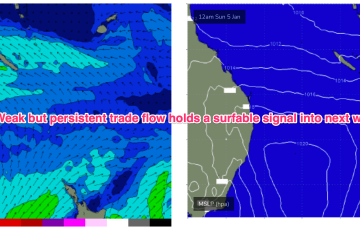
Either way, it’s looking like our eastern swell window is about to get into the swing of things and finally resume its regular summer programming.
Primary tabs
/reports/forecaster-notes/south-east-queensland-northern-new-south-wales/2025/01/24/meh-the-short
thermalben
Friday, 24 January 2025
/reports/forecaster-notes/south-east-queensland-northern-new-south-wales/2025/01/22/complex-outlook
thermalben
Wednesday, 22 January 2025
The approaching southerly change should be getting close to the Qld border around dawn..
/reports/forecaster-notes/south-east-queensland-northern-new-south-wales/2025/01/20/tuesday-the-pick
thermalben
Monday, 20 January 2025
We’ve got plenty more swell on the way, and much better winds on Tuesday as the synoptic pattern relaxes, allowing a light variable airstream to envelop the coast.
/reports/forecaster-notes/south-east-queensland-northern-new-south-wales/2025/01/17/decent-spell
thermalben
Friday, 17 January 2025
The best low for Northern NSW/SE Qld surfers is already sitting just north of New Zealand, and is generating E’ly swells that will feed into Sunday’s mix and provide solid 4ft waves across most exposed coasts, holding into Monday.
/reports/forecaster-notes/south-east-queensland-northern-new-south-wales/2025/01/15/complex-synoptics
thermalben
Wednesday, 15 January 2025
The models have moved around quite a bit for the short term. But there are positives to glean.

/reports/forecaster-notes/south-east-queensland-northern-new-south-wales/2025/01/13/large-southerly
thermalben
Monday, 13 January 2025
We've got a large, windy outlook from Friday through the weekend.

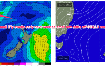
/reports/forecaster-notes/south-east-queensland-northern-new-south-wales/2025/01/10/small-workable-e
freeride76
Friday, 10 January 2025
During this time, models are suggesting a small trough of low pressure will bud off the inland low and drift into the Coral Sea off the SEQLD Coast, which enhances the SE flow through SEQLD, extending down into NENSW by Tues, although winds will remain E/NE-NE south of Coffs.
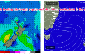
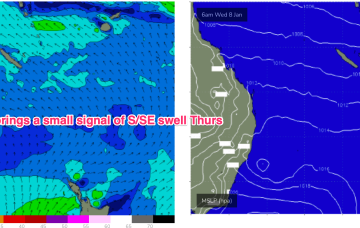
/reports/forecaster-notes/south-east-queensland-northern-new-south-wales/2025/01/08/summer-discontent
freeride76
Wednesday, 8 January 2025
A small trough of low pressure has stalled off Seal Rocks with a SE infeed south of the trough expected to ease over the next 24 hrs and a light/variable flow north of the trough. Apart from this short-range feature, which is whipping up some local, short range swell for Central/Southern NSW extending up to the MNC, pressure gradients in the Tasman and Coral Seas remain very weak.
/reports/forecaster-notes/south-east-queensland-northern-new-south-wales/2025/01/06/grovel-days-ahead
freeride76
Monday, 6 January 2025
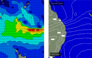
The current synoptic situation has a Groundhog Day feel to it, with another very weak high pressure cell in the Tasman (1019hPa), directing a mod N’ly flow along the temperate NSW coastline, with a weakening Tradewind flow in the Coral Sea contracting northwards.
/reports/forecaster-notes/south-east-queensland-northern-new-south-wales/2025/01/03/long-term-outlook
freeride76
Friday, 3 January 2025
Further ahead and we have a dynamic outlook on the cards. An inland low and trough - a hybrid monsoonal feature- looks to approach the NSW coast, with a strengthening NE infeed into the system.