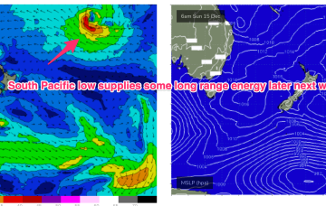
Further ahead and we have a dynamic outlook on the cards. An inland low and trough - a hybrid monsoonal feature- looks to approach the NSW coast, with a strengthening NE infeed into the system.
Primary tabs
/reports/forecaster-notes/south-east-queensland-northern-new-south-wales/2025/01/03/long-term-outlook
freeride76
Friday, 3 January 2025
/reports/forecaster-notes/south-east-queensland-northern-new-south-wales/2024/12/31/tiny-surf-gets
freeride76
Wednesday, 1 January 2025
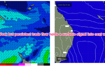
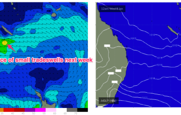
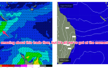
The outlook for next week is…….awesome if you are a kid or learning to surf. Day after day of small surf from the E and light winds.

/reports/forecaster-notes/south-east-queensland-northern-new-south-wales/2024/12/30/light-winds-and
freeride76
Monday, 30 December 2024
Very weak pressure gradients in the Tasman and Coral Seas as we count down 2024.
/reports/forecaster-notes/south-east-queensland-northern-new-south-wales/2024/12/27/huey-goes-awol
freeride76
Friday, 27 December 2024
Fresh N’lies bring some workable NE windswell for the keen, up to the 2-3ft range. N’lies will blow all day in SEQLD with a trough bringing a S’ly change to Coffs around early morning, late a’noon across the North Coast .
/reports/forecaster-notes/south-east-queensland-northern-new-south-wales/2024/12/25/s-swells-easing
freeride76
Wednesday, 25 December 2024
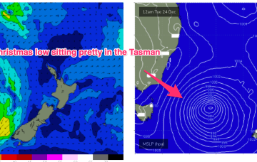
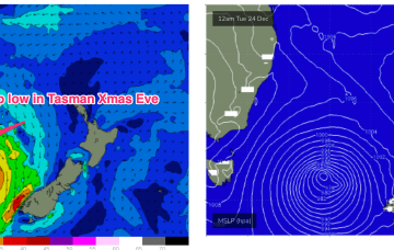
A deep low is moving slowly towards New Zealand but the main bulk of the fetch has already rotated away from the East Coast with an off axis fetch aimed at South Pacific Islands. Elongated high pressure is moving into the Tasman with an approaching trough, front and cut-off low expected to tighten the pressure gradient leading to freshening N’lies from Boxing Day.

/reports/forecaster-notes/south-east-queensland-northern-new-south-wales/2024/12/23/s-swell-coming
freeride76
Monday, 23 December 2024
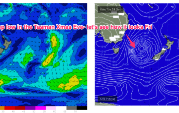
A cold front currently pushing into the Tasman spawns a low pressure system, expected to rapidly deepen later today and o/night before becoming slow moving in the south-central Tasman.
/reports/forecaster-notes/south-east-queensland-northern-new-south-wales/2024/12/20/quality-surf
freeride76
Friday, 20 December 2024
Still looking good for Sat. Current ASCAT (satellite windspeed) pass shows a Tasman low with a long fetch of strong S-S/SE winds well positioned in the swell window.
/reports/forecaster-notes/south-east-queensland-northern-new-south-wales/2024/12/18/southerly-blast-s
freeride76
Wednesday, 18 December 2024
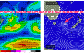
We currently have a deepening trough of low pressure developing behind a front which is bringing fresh and gusty S’ly winds up the NSW coastline, extending into the sub-tropics through the day. This trough of low pressure deepens into a surface low in the Tasman and is expected to track in a northerly direction through the short term.
/reports/forecaster-notes/south-east-queensland-northern-new-south-wales/2024/12/16/swells-around-the
freeride76
Monday, 16 December 2024
We’ll see some swell from this pattern, first from the initial short range S swell and then some better quality S/SE swell as the surface low retrogrades from near the South Island back into the Tasman. Read on for details and a sketch of the Xmas week.
/reports/forecaster-notes/south-east-queensland-northern-new-south-wales/2024/12/13/definitely-more
freeride76
Friday, 13 December 2024
Latest model runs have amplified this trough and a resulting trough of low pressure in the Tasman. There’s still some model divergence to get through so expect some revisions but odds are firming off a sizey S tending S/SE swell event from Thurs, as the trough deepens in the Central Tasman.