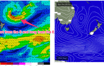
The current low located near Lord Howe Island dissipates through today with easing winds along the Eastern Seaboard as a result. Weak pressure gradients then occupy the Tasman through the mid week, offering up good conditions as a long range E swell makes landfall.
Primary tabs
/reports/forecaster-notes/south-east-queensland-northern-new-south-wales/2024/10/21/short-the-s-and
freeride76
Monday, 21 October 2024
/reports/forecaster-notes/south-east-queensland-northern-new-south-wales/2024/10/18/ordinary-start
freeride76
Friday, 18 October 2024
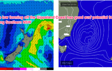
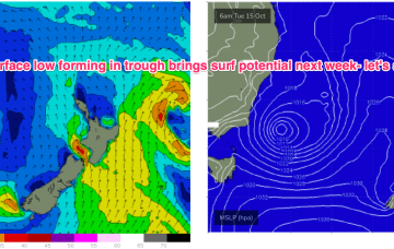
A low is expected to move E of Tasmania o/night and form a broad low pressure trough in the Tasman driving N-NW’ly then S’ly winds up the coast before moving NE as a surface low over the weekend. That will be the second surface low in succession to form in the Tasman and we may yet see a third develop later next week.

/reports/forecaster-notes/south-east-queensland-northern-new-south-wales/2024/10/16/small-blend
freeride76
Wednesday, 16 October 2024
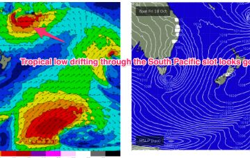
In the tropics a trough deepening between Vanuatu and Fiji forms a broad surface low which tracks southwards through the wide open South Pacific slot between the North Island and tropical island chains, generating some tasty E’ly swell next week.
/reports/forecaster-notes/south-east-queensland-northern-new-south-wales/2024/10/14/mix-swells-week
freeride76
Monday, 14 October 2024
Surf now looks fun without being spectacular. A polar low passing to the south is sending long period S swells up the pipe. A modest but broad trade fetch in the Coral Sea is supplying some small E’ly tradeswell.

/reports/forecaster-notes/south-east-queensland-northern-new-south-wales/2024/10/11/few-small-swells
freeride76
Friday, 11 October 2024
We have a broad front passing into the Tasman and a northwards moving trough, with a high pressure ridge filling in behind those short range features. The front will supply workable levels of S swell Sun but winds will be a problem with a a mod/fresh S’ly flow, tending SE’ly- E’ly during the day.
/reports/forecaster-notes/south-east-queensland-northern-new-south-wales/2024/10/09/generally-low
freeride76
Wednesday, 9 October 2024
The current S swell will ease through tomorrow with a pair of cold fronts passing into the Tasman Thurs/Fri ahead of another trough and high pressure ridge. In short, we’ll see pulses of S swell but favourable winds will be short-lived.
/reports/forecaster-notes/south-east-queensland-northern-new-south-wales/2024/10/07/nothing-special
freeride76
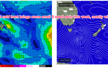
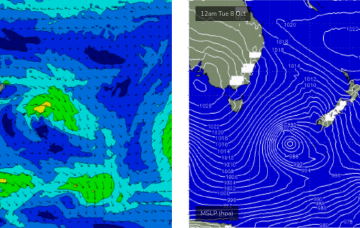
Monday, 7 October 2024
We’ve currently got a cold front linked to a compact parent low moving across and SE of Tasmania with high pressure tracking through the bight towards Victoria. That will bring a robust S’ly change tomorrow and some workable S swell for temperate NSW, with a trough in the sub-tropics tilting the change more S/SE-SE later tomorrow into Wed.
/reports/forecaster-notes/south-east-queensland-northern-new-south-wales/2024/10/04/large-weekend
thermalben
Friday, 4 October 2024
The weekend’s large S/SE swell is still expected to push through, but unfortunately, winds are still looking difficult for many areas.
/reports/forecaster-notes/south-east-queensland-northern-new-south-wales/2024/10/02/great-swell-due
thermalben
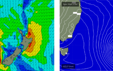
Wednesday, 2 October 2024
I still really like the way this system is developing so the swell potential remains high this weekend. Unfortunately, the same can’t be said about local winds.
/reports/forecaster-notes/south-east-queensland-northern-new-south-wales/2024/09/30/plenty-swell
thermalben
Monday, 30 September 2024
Friday is probably the best day of the week as we’ll see plenty of S/SE swell and lighter winds as a weak ridge of high pressure settles across the region.
