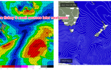
A trough between them moves offshore tomorrow forming a fast moving trough of low pressure in the Tasman, which tracks rapidly NE. We’ll see a spike of S swell from this system, downgraded from Mon. A following front and trough now looks stronger, earning an upgrade.
Primary tabs
/reports/forecaster-notes/south-east-queensland-northern-new-south-wales/2024/09/11/series-s-swells
freeride76
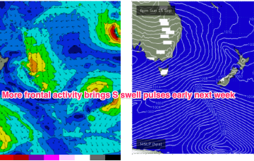
Wednesday, 11 September 2024
/reports/forecaster-notes/south-east-queensland-northern-new-south-wales/2024/09/09/dynamic-outlook
freeride76
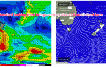
Monday, 9 September 2024
Thursday looks like a dynamic day. A trough deepens and inflames a strong S’ly flow along the NSW coast, extending into the Tasman.

/reports/forecaster-notes/south-east-queensland-northern-new-south-wales/2024/09/06/typical-spring
freeride76
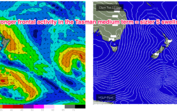
Friday, 6 September 2024
Models are still struggling to resolve this trough but there are reasonable grounds to suggest the trough may deepen and form a surface low in the Tasman late next week.
/reports/forecaster-notes/south-east-queensland-northern-new-south-wales/2024/09/04/easing-s-swells
freeride76
Wednesday, 4 September 2024
Once that high moves offshore we’ll see N’lies kick in for the rest of the week with only a weak trough expected to interrupt that pattern. No major swells on the radar through the short or medium term.
/reports/forecaster-notes/south-east-queensland-northern-new-south-wales/2024/09/02/some-size-the-s
freeride76
Monday, 2 September 2024
The front brings a bog standard blast of winter/spring style S swell through the short term, with the high quickly moving into the Tasman.
/reports/forecaster-notes/south-east-queensland-northern-new-south-wales/2024/08/30/minor-swells-the
freeride76
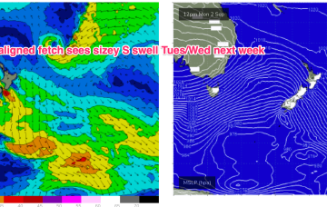
Friday, 30 August 2024
We’ll see a deep parent low finally moving below Tasmania early next week after generating multiple large swells for Victoria. As the low moves eastwards we should see a final frontal passage through Bass Strait and with a fetch SE of Tasmania, generating a sizey S swell for Tues/Wed next week.
/reports/forecaster-notes/south-east-queensland-northern-new-south-wales/2024/08/28/small-blend
freeride76
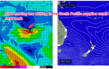
Wednesday, 28 August 2024
The gale force fetches out of Bass Strait are supplying small S’ly pulses favouring Central/Mid North NSW. A slow moving low in the South Pacific will supply some very inconsistent background E swell into the weekend and next week.
/reports/forecaster-notes/south-east-queensland-northern-new-south-wales/2024/08/26/mostly-nlies-week
freeride76
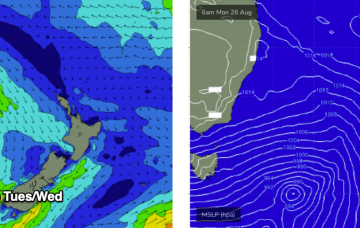
Monday, 26 August 2024
The pattern of strong, zonal W’lies tied to polar lows and embedded cold fronts and weak mobile high pressure won’t offer much north of Seal Rocks but we will see some small S swells generated by gales out of Bass Strait this week with a mostly NW-W flow across southern NSW and NW-N in the sub-tropics. There’ll be a few small windows, favouring the MNC.

/reports/forecaster-notes/south-east-queensland-northern-new-south-wales/2024/08/23/not-much-offer
thermalben
Friday, 23 August 2024
There is also a risk of northerlies through this period, but we’ll take a closer look at the specs on Monday.
/reports/forecaster-notes/south-east-queensland-northern-new-south-wales/2024/08/21/time-grovel
freeride76
Wednesday, 21 August 2024
Very spring-like synoptic chart with mobile high pressure moving NE through the Tasman and a N’ly flow across most of the eastern seaboard.