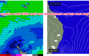
I’m expecting a small, slow start on Saturday with residual energy from today, however by lunchtime...
Primary tabs
/reports/forecaster-notes/south-east-queensland-northern-new-south-wales/2024/06/07/small-weekend
thermalben
Friday, 7 June 2024
/reports/forecaster-notes/south-east-queensland-northern-new-south-wales/2024/06/05/offshore-wind
freeride76
Wednesday, 5 June 2024
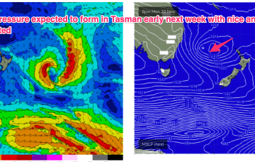
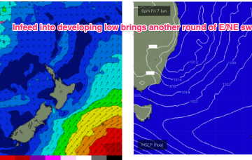
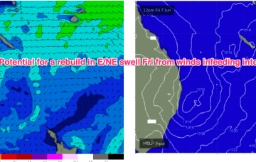
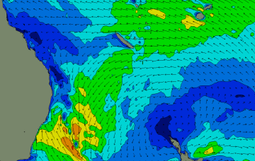
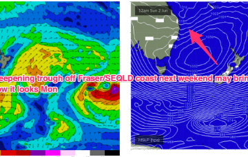
Troughy remnants remain off the North Coast and South Coast interior and these troughs are expected to deepen and reform into another surface low through Fri into the weekend with another round of E/NE infeed swell and S swell although much more subdued than last weekends swell.
/reports/forecaster-notes/south-east-queensland-northern-new-south-wales/2024/06/03/nice-run-offshore
freeride76
Monday, 3 June 2024
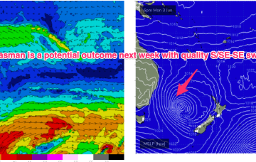
A trough line connected to the low remains angled SW/NE in the Tasman with a N-N/NE infeed along the trough line. With the movement of the low into the coast, winds on the southern flank are now out of the swell window so we’ll be relying on the NE infeed into the trough and potential small lows forming in the trough line for swells in the short term once the current S'ly swell fades out.
/reports/forecaster-notes/south-east-queensland-northern-new-south-wales/2024/05/31/fun-swells-the
thermalben
Friday, 31 May 2024
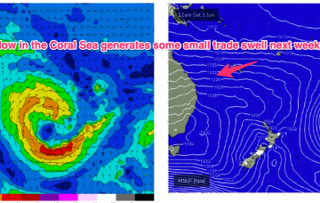
A broad high pressure system in the north-eastern Tasman Sea has a reasonable trade flow atop its northern flank.
/reports/forecaster-notes/south-east-queensland-northern-new-south-wales/2024/05/29/some-nly-days
freeride76
Wednesday, 29 May 2024
With the low near Bass Strait we should have an offshore outflow across most of the region- so offshore winds all day. A fun blend of S-S/SE and E/NE swells will be on hand.
/reports/forecaster-notes/south-east-queensland-northern-new-south-wales/2024/05/27/s-pulses-give-way
freeride76
Monday, 27 May 2024
A pair of weak cold fronts are expected to pass over Tasmania in the short term, generating small S swells which will overlap with the last pulses coming from the polar low now SE of New Zealand. A dynamic, troughy pattern looks set to unfold over the weekend.
/reports/forecaster-notes/south-east-queensland-northern-new-south-wales/2024/05/24/small-s-swells
freeride76
Friday, 24 May 2024
High pressure is approaching Tasmania with a weak trough expected to linger in the Tasman and across the North Coast over the weekend and lead to mostly light breezes, especially Sun. A complex polar low is approaching the NZ corridor and although the frontal progression looks a notch less favourable for swell production up the East Coast we’ll still see S’ly groundswell pulses over the weekend
/reports/forecaster-notes/south-east-queensland-northern-new-south-wales/2024/05/22/small-fun-mixed
freeride76
Wednesday, 22 May 2024
Local swell sources dry up but polar lows better aimed at Pacific targets will send some long period S swell up the pipe over the weekend and early next week before a more subdued outlook takes hold.
/reports/forecaster-notes/south-east-queensland-northern-new-south-wales/2024/05/20/high-in-the-bight
freeride76
Monday, 20 May 2024
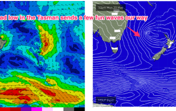
The remnants of the weekend’s low pressure trough are currently being reinforced by another cold front and expected to form a broad low pressure system in the Tasman in the short term which will supply some fun waves this week with an easing trend into the weekend.
/reports/forecaster-notes/south-east-queensland-northern-new-south-wales/2024/05/17/big-windy-and
freeride76
Friday, 17 May 2024
Big and windy for Sun with fresh to strong SW-S winds early, tending strong S’ly all day.