Great weekend, with larger surf likely from later next week

Victorian Forecast by Craig Brokensha (issued Friday July 11th)
Best Days: Today ahead of the change Surf Coast, tomorrow Surf Coast, Sunday, Monday afternoon, Tuesday morning Surf Coast, Thursday onwards
Features of the Forecast (tl;dr)
- Moderate sized mid-period W/SW swell for late today and tomorrow AM, easing
- Late increase in inconsistent, moderate sized W/SW groundswell, easing Sun
- Fresh NW winds tomorrow, strong N/NW-N tending N/NW Sun
- Moderate + sized mix of mid-period swells Mon AM, easing
- Improving conditions Mon with gusty SW tending W/NW winds (W/NW likely from early to the west but lumpy)
- Smaller Tue with NW tending W/NW winds
- Mod-large, long-period groundswell from Thursday through next weekend highly likely
Recap
A slight drop in size was seen from Wednesday yesterday, with deteriorating conditions across all but protected spots on the Surf Coast as a strong cold front moved in across the state. This kicked up a localised windswell through the afternoon, with an underlying pulse of new W/SW groundswell in the mix, both easing into this morning.
Conditions are much cleaner with 3-4ft sets on the Surf Coast reefs and we should a secondary front move through this afternoon, bringing a strong SW change that will revert back to the W later. A late increase in mid-period swell is due with this change, but more on that below.

More size and better conditions this morning
This weekend and next week (Jul 12 - 18)

This afternoon’s front will bring with it a moderate sized increase in mid-period W/SW swell, with a great fetch of strong W/SW winds currently being projected through our western swell window, at the entrance to Bass Strait.
This swell is due to kick later today and ease into tomorrow morning from 3-4ft across the Surf Coast and 6ft to the east, with a late increase in W/SW groundswell on the cards, though more so for Sunday morning, easing through the day.
The groundswell component was generated by the earlier stages of today’s frontal system, with a great fetch of W/NW gales produced to the south-west of Western Australia. This should come in at a less consistent but similar 3ft to occasionally 4ft on the Surf Coast early Sunday, 5-6ft to the east before easing gradually through the day.

Local winds look great all weekend with a fresh NW’ly expected to persist all day tomorrow, stronger N/NW-N on Sunday morning before reverting back to the N/NW into the afternoon.
Into the evening, another cold front is expected to cross the region and this will have a fetch of strong SW winds attached to it, bringing another moderate + sized increase in mid-period swell for Monday morning.
Local conditions for this swell aren’t as favourable with strong SW winds through Bass Strait likely to tend locally W/NW across the Surf Coast, adding lots of lump and imperfection to things in the morning. Another approaching front should see winds ease and tend back to the W/NW through the afternoon across all locations, providing improving conditions.
Size wise the Surf Coast should come in at 4ft+ or so in the morning, easing through the day with 6ft+ sets to the east, smaller Tuesday under offshore NW tending W/NW winds.
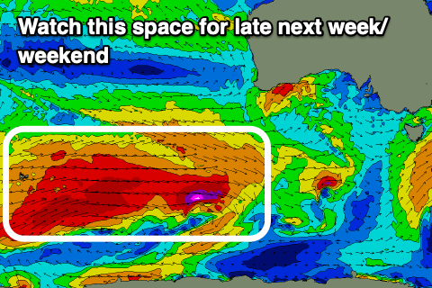
Longer term, we’re looking at a significant polar frontal progression firing up around and east of the Heard Island region from this weekend, with multiple storms expected to generate an expansive, elongated fetch of severe-gale westerly winds, with embedded storm-force winds likely, moving closer towards us through the week.
This looks to generate a moderate to large run of inconsistent, long-period SW groundswell from Thursday next week, with the largest increase due Friday afternoon/Saturday.
At this stage we’re looking at a peak in the 6ft+ range across the Surf Coast and 8ft+ to the east but we’ll have a closer look at this on Monday. Local winds favourable as the progression stays at arms length from us later next week, with a possible W-W/SW change Saturday. See you back here Monday and have a great weekend!
Comments
Now that is more like winter.
great weekend of surf and week is looking good....bit more size would be great