Indonesia/Maldives forecast Jul 10

Indian Ocean Basin analysis by Craig Brokensha (issued Thursday 10th July)
This week through next (July 11 - 18)
We saw the large S/SW groundswell really starting to muscle up through yesterday afternoon, strong on dark before easing this morning. It performed well across some spots but was a little underwhelming at others around Bali.
A downwards trend is due through tomorrow further Saturday morning, though later in the day, an inconsistent S/SW groundswell is due across selected spots, generated by a late forming polar front, south-southwest of Western Australia earlier this week. This will likely just halt the easing trend with Sunday morning coming in smaller
Into Sunday afternoon, a new, long-range SW groundswell is due, with no change to the expected size.
This was generated by a strong but distant low that formed south of South Africa over the weekend and should provide the most size later Sunday and into Monday morning.
Smaller surf is due into Tuesday morning, while a moderate sized, mid-period S/SW swell is due into the afternoon and Wednesday morning, generated by healthy but relatively weak frontal activity currently pushing towards Western Australia.
We then look towards the tricky S/SW groundswells due into the end of the week, with a strong but disjointed progression of strong polar storms due to form west of the Heard Island region from today, traversing east before projecting under Australia through next week.
There are at least three separate swell producers and it looks like in short that the models are over-forecasting the size from Friday through Sunday next week.
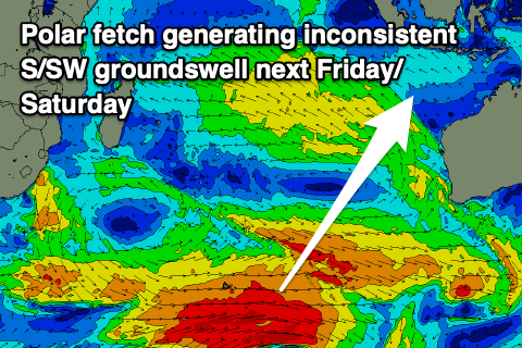
Overlapping long-period swell trains look to come in smaller than expected, with the first polar storm expected to generate an inconsistent, moderate + sized S/SW groundswell for Thursday, peaking into the afternoon, with a secondary polar low forming around the Heard Island region this weekend due to produce a secondary stronger increase in S/SW groundswell for later Friday and Saturday morning.
While large in size it’s not likely to top 8ft, with further pulses into the weekend possibly coming in a touch stronger, with the European model, ECWMF leading the way. We’ll reassess the outlook on Tuesday.
The Mentawais will be smaller owing to the activity forming further south and aimed better for Australia.
Our current SE trades will persist over the coming days, swinging back more E/SE through the weekend while strengthening.
Next week E/SE-SE winds are due, with light, local offshore winds due each morning.
For the Mentawais, local winds look variable though southern locations might see E/SE-SE breezes from today through the weekend, possibly kicking up again later next week.
----------------------------------------------
Maldives:
We should be seeing large levels of super-charged S/SE trade-swell across the region today, persisting tomorrow morning before easing slowly over the weekend from the SE thanks to the significant fetch of E/SE-SE breaking down.
The downwards trend still looks to be short-lived, with a re-intensification of trades expected through this weekend and into early next week.

A more substantial fetch of strong SE trades are expected to develop south-southeast of the region, with a rapid jump in large S/SE trade-swell due through Monday afternoon, peaking Tuesday before starting to ease slowly Wednesday. This will be thanks to the trade-flow reaching a peak intensity early Tuesday, slowly breaking down thereafter.
The easing trend will be slow thanks to the trades only slowly weakening, remaining moderate + in size until next weekend.
S’ly groundswell wise, we’ve got some underlying energy due tomorrow, with a secondary pulse for Sunday, easing thereafter into early next week.
Local winds are set to strengthen from the W/NW across northern and central locations tomorrow, persisting through the weekend with variable winds to the south.
Gusty W/NW winds look to persist early-mid next week before weakening later week.
Eastern Indonesia:
Easing surf tomorrow.
Small to moderate sized, reinforcing S/SW groundswell for later Saturday/Sunday morning.
Moderate + sized, inconsistent SW groundswell building Sunday afternoon to 4-6ft, easing Monday from a similar size across exposed breaks.
Moderate sized mid-period S/SW swell for Tuesday afternoon and Wednesday morning to 4-5ft+.
Moderate + sized inconsistent S/SW groundswell building Thursday, peaking later to 5-6ft across exposed breaks.
Larger, inconsistent S/SW groundswell for Friday afternoon, possibly reaching 8ft later with similar sized pulses for next weekend (under model forecasts).
Fresh SE trades over the coming days, swinging back more E/SE through the weekend while strengthening.
Next week E/SE-SE winds are due, with light, local offshore winds due each morning.
Uluwatu 16-day Forecast Graph/WAMs
Western Indonesia/Mentawais/South Sumatra:
Easing S’ly swell over the coming days.
Moderate + sized, inconsistent SW groundswell building Sunday afternoon to 6ft, easing Monday from a similar size across exposed breaks.
Moderate to large inconsistent S/SW groundswell for later next week/weekend to 6ft+ across exposed breaks.
Variable winds this period, tending E/SE-SE across southern locations from today through the weekend and again possibly late next week.
Mentawai 16-day Forecast Graph/WAMs
Maldives:
Super-charged S/SE-SE trade-swell easing from 6ft+ across the southern atolls, smaller Male.
Super-charged S/SE trade-swell event building rapidly Monday, peaking Tuesday to 6-8ft across the southern atolls (smaller Male). Swell easing slowly through Wednesday afternoon and the end of the week.
Strengthening W/NW winds across northern and central locations tomorrow, persisting through the weekend, variable to the south.
Gusty W/NW winds early-mid next week, weakening later week.
Comments
Latest notes are live.
Thanks Craig , my expectations got out of hand and NL had size late yesterday arvo but it was a big low tide so not ideal & this morning was too much south so lots of lumps heading down the badung strait but only a few getting directed in . Such a weird place as a similar size & direction a few months ago and lacerations was pumping, got me fucked how not just tide but current funnels the swell in & sometimes doesn’t . It’s always a bit of a lottery over here .
Cheers Supa.
The models are firming on the progression through next week, looks like we'll be upgrading.
no where near 6' here (imposibles) today may 2, i guess sth swell?
Oh yeah the swell for this weekend was south and average. Better SW groundswell for this arv.
Thoughts on this Friday Saturday Sunday for Bali East Java lord craig? Models looking wild!! :)
Models are over-cooking it, by quite a bit. Details tomorrow.
Thanks Craig ya legend :)
Yes I thought as much , looking forward to today’s report.
thoughts that you're a geezer?
Shout out to Pat the underground charger who caught wave of the day at the recent Speedies swell on a delightful custom channel bottom.