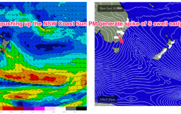
SW gales push through Bass Strait and off the Far South Coast Sun night and into Mon with the bulk of the frontal winds now likely to reach Coffs around 7am, Byron by lunch and the border around school pickup
Primary tabs
/reports/forecaster-notes/south-east-queensland-northern-new-south-wales/2025/03/14/small-surf-over
freeride76
Friday, 14 March 2025
/reports/forecaster-notes/south-east-queensland-northern-new-south-wales/2025/03/12/nothing-much
freeride76
Wednesday, 12 March 2025
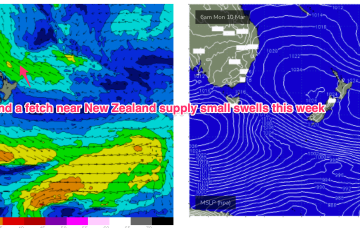
A weak trade flow in the Coral Sea now only looks capable of generating minor background E’ly swells. N’ly winds will increase over the weekend as a more significant trough and frontal system pushes into the Tasman next week, generating swells from the southern quadrant.

/reports/forecaster-notes/south-east-queensland-northern-new-south-wales/2025/03/10/ordinary-surf
freeride76
Monday, 10 March 2025
The whole synoptic pattern on the East Coast in the wake of Alfred is a moist onshore flow which looks to persist through into the mid week. A weak front races across the lower Tasman before reinforcing high pressure slips into the Tasman to reset the flow, albeit at a weaker level. Not a great deal of swell generated by any feature this week.
/reports/forecaster-notes/south-east-queensland-northern-new-south-wales/2025/03/07/north-the-storm
freeride76
Friday, 7 March 2025
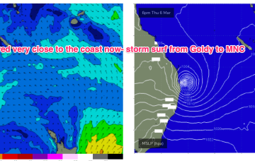
TC Alfred is maintaining intensity as a low end Cat 2 cyclone, as it moves slowly towards SEQLD at a walking pace. Gales to storm force winds are located across the SE and SW quadrants.
/reports/forecaster-notes/south-east-queensland-northern-new-south-wales/2025/03/05/areas-the-south
freeride76
Wednesday, 5 March 2025
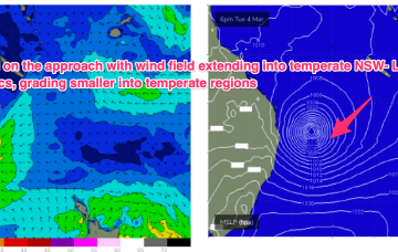
Massive surf from the Moreton Bay Islands across the Gold Coast and down through Northern NSW will continue until the cyclone crossing, with much smaller surf on the Sunshine Coast and into temperate NSW. It’s been an epic event with a gnarly exclamation point expected as Alfred makes landfall.
/reports/forecaster-notes/south-east-queensland-northern-new-south-wales/2025/03/03/buckle-tc-alfred
freeride76
Monday, 3 March 2025
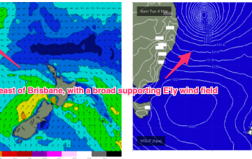
TC Alfred (982hPa) is currently about 465 km east north-east of Brisbane and moving SE at 7kts holding intensity as a Cat 2 system continuing to generate pumping cyclone surf.
/reports/forecaster-notes/south-east-queensland-northern-new-south-wales/2025/02/28/extended-period
freeride76
Friday, 28 February 2025
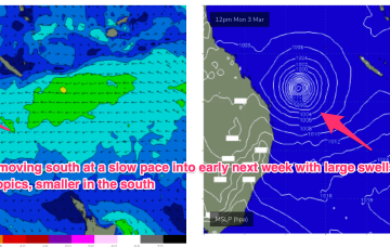
Under current modelling, most major models have TC Alfred, or a sub-tropical cyclonic descendant of it, slow moving off the SEQLD coast early next week possibly drifting erratically through the whole week. That leads to high confidence for an extended period of very large surf in the sub-tropics, possibly of an historic nature in terms of size and duration.
/reports/forecaster-notes/south-east-queensland-northern-new-south-wales/2025/02/26/three-cyclones
freeride76
Wednesday, 26 February 2025
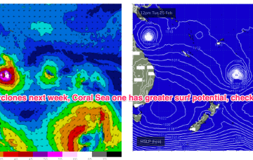
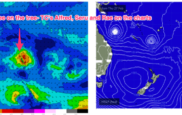
TC Alfred is in the Coral Sea, currently about a 1000km NE of Mackay and slow moving, expected to slowly track southwards from today. TC Rae has sped off SE to the graveyard and TC Seru is located between Vanuatu and Fiji and moving S/SE. In this complex brew, we’ll see multiple swell trains from the NE-E quadrant, although large swells may be confined to more northerly regions as models firm on a CQ coastal crossing for TC Alfred (still uncertainty over this track!) and the South Pacific cyclones track south-eastward, then eastwards as dissipating systems.
/reports/forecaster-notes/south-east-queensland-northern-new-south-wales/2025/02/24/plenty-trade
freeride76
Monday, 24 February 2025
A very long and broad tradewind fetch is anchored on a NW/SE axis by twin tropical cyclones. TC Alfred is meandering in the Coral Sea NE of Cairns, while TC Rae is NW of Fiji and moving south-south westwards.

/reports/forecaster-notes/south-east-queensland-northern-new-south-wales/2025/02/21/another-round
freeride76
Friday, 21 February 2025
The monsoon trough is still active with a tropical low off the N.QLD coast and lows in the South Pacific through the Island chains. Medium term surf potential rests on these tropical lows, with the supporting tradewind belt supplying plenty of energy in the interim, focussed on the sub-tropics.