Strong swells from later week

Victorian Forecast by Craig Brokensha (issued Monday July 14th)
Best Days: Today, tomorrow morning, Thursday ahead of the change, Friday, Saturday selected spots, Sunday Surf Coast
Features of the Forecast (tl;dr)
- Easing swell tomorrow with mod-fresh W/NW winds
- Low point in swell Wed AM ahead of building mid-period surf into the PM
- Fresh NW winds Wed
- Mod-large SW groundswell Thu with strong NW tending W/NW then SW winds into the mid-PM
- Larger W/SW grounswell for Fri, peaking through the day with fresh NW tending N winds (possibly N/NE to the east)
- Easing swell Sat, with a mod-large reinforcing W/SW groundswell for the PM
- Strong N tending N/NW winds Sat
- Easing swell Sun with W/NW-NW winds
Recap
Saturday was great across the Surf Coast with clean conditions and a mix of mid-period swell for the morning and stronger groundswell into the late afternoon coming in mostly around 4ft. Yesterday the swell was a bit smaller and slower under stronger northerly winds, favouring the beaches more so than the reefs.
Conditions did clean up later on the Surf Coast ahead of an approaching frontal system, with the swell from that front peaking this morning. It’s lower period and mixed but a good size on the sets, best across the Surf Coast again.

Great surf Saturday
This week and weekend (Jul 15 - 20)
Today’s mid-period swell will back off into this afternoon, further tomorrow and the Surf Coast will be the pick of it again under persistent, moderate to fresh W/NW winds. Easing 3ft sets are due, bigger to the east.
A low point in swell is expected Wednesday morning but it will only be temporary, with the afternoon seeing an increase in mid-period swell thanks to a strong frontal progression pushing close towards us tomorrow, weakening on approach.
This first storm will shed off a significant frontal progression that’s currently taking place across the Heard Island region, with the progression due to continue east-northeast, under the country this week, bringing with it multiple pulses of moderate to large W/SW-SW groundswells.
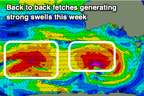
The first pulse for Thursday looks to arrive from a SW direction, with a great fetch of gale to severe-gale W/SW winds due to be generated well south of Western Australia today, generating a good pulse of size to 4-5ft+ on the Surf Coast and 6-8ft to the east.
Strong NW tending W/NW winds will favour the Surf Coast before shifting SW into the mid-late afternoon as the next swell generating front moves in.
This front will be similar in strength to the first low, but slightly more north in location and more broad in scope.
We should see this generating a larger W/SW groundswell for Friday, peaking through the day to 6ft across the Surf Coast and 8ft+ to the east. Another approaching front may bring fresh NW tending N winds into the afternoon, even tending N/NE to the east into the afternoon but we’ll confirm this on Wednesday.
Stronger N tending N/NW winds are due on Saturday as the swell from Friday eases. The easing trend will be slow and softened as a slightly smaller but still solid reinforcing W/SW groundswell fills in, generated by a final frontal system moving under Western Australia Thursday.
Surf to 4-6ft should hold across the Surf Coast into the afternoon, 6-8ft to the east before easing Sunday under W/NW-NW winds.
Longer term the outlook for early-mid next week looks slower so make the most of the incoming frontal progression and larger swells.
Comments
what a treat craigos, thanks for this forey
Would this mean a nice wave or two at somewhere like ... ooooh ... Roadknight on Friday / Sat?
Asking for a kook friend who wants to get back in the water after a year out ...
13th Beach, Woolamai, or Fairhaven will be an easy paddle out.
Plenty of protected spots about Patrick, Lotsa swell, choose wisely.
Cheers Blackers. My ‘friend’ is naturally a coward when it comes to big surf so protected it shall be!
nice this morning with little crowds. gotta love winter
Better than the numbers let on!
super quiet and plenty of waves on offer