Tuesday is the pick of the forecast period

South-east Queensland and Northern NSW Surf Forecast by Ben Matson (issued Mon Jan 20)
Features of the Forecast (tl;dr)
- Solid combo of easing SE and building E swell on Tues (biggest Northern NSW, smaller SE Qld) with light winds and sea breezes
- Easing size Wed with good AM winds
- Smaller mix of swells Thurs with early light AM winds
- Strengthening northerlies on Friday, nothing worthwhile
- Average weekend of waves
- Long term suggests more S'ly swell events that'll favour Northern NSW, and not SE Qld
Recap
Surf conditions seem to have been either feast or famine over the last few days, with a variety of factors affecting various coasts. A common denominator has been the state of the sand, which is affecting success not just across the beachbreaks, but also a wide range of regional points that would have otherwise delivered great waves under the weekend’s synoptic pattern. Otherwise, on the balance we saw surf/wind/swell conditions generally come in as expected - Saturday saw an early combo of east and south swell with 2-3ft sets in SE Qld, bigger near 3-4ft in Northern NSW, and with generally light winds ahead of a southerly change that staggered its way along the coast through the day, bringing gales to most areas by the evening (and a punchy windswell in its wake). Sunday then offered large, unruly 6-8ft surf throughout Northern NSW, with only a handful of protected locations - such as The Pass, below - managing to make sense of the noisy regional conditions. SE Qld saw a wide range in size from wind affected 4-6ft at south swell magnets to 3-4ft along the Gold Coast points, but the Sunny Coast dipped out with less size - too small for the points and unfavourable winds for the open beaches (d'oh!). Wave heights eased back this morning with abating conditions, ahead of a rebuilding SE swell through the day that’s now pushing 6ft at exposed spots in Northern NSW. SE Qld is smaller, around 4ft at south facing beaches and 3ft along the semi-exposed points, with winds from the southern quadrant.
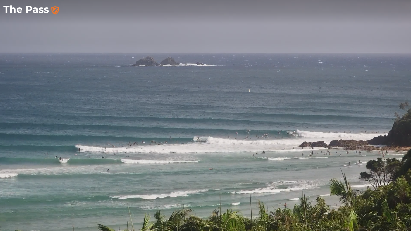
Pumping, well populated options at The Pass on Sunday
This week (Jan 21 - 24)
We’ve got plenty more swell on the way, and much better winds on Tuesday as the synoptic pattern relaxes, allowing a light variable airstream to envelop the coast.
Today’s SE swell will ease into Tuesday, but it’ll be replaced by a new swell generated by a final low pressure system associated with our recent complex synoptic pattern.
This low moved from a position north of New Zealand last week, into the north-eastern Tasman Sea over the weekend - it’s now moving towards the Australian East Coast, and weakening - however has a healthy easterly fetch on its southerly flank.
Unfortunately, the fetch is primarily aimed into Southern NSW however we’ll see a spread of E/SE swell along Northern NSW into Tuesday afternoon, easing from Wednesday morning onwards. Surf size should manage 3-5ft south from Byron (maybe some lingering bigger sets early on, from today's pulse), but the swell direction won’t be quite as favourable for SE Qld so we’re looking at 2-3ft surf across most of the Gold and Sunshine Coast (perhaps some rare 4ft sets at exposed northern ends and south swell magnets).
Keep an eye out for mid-late afternoon NE sea breezes along the coast.
An approaching front from the south will slowly freshen northerly winds on Wednesday morning, though early morning should see a NW flow across most coasts, which will favour the beaches (banks pending, of course).
Although the change is expected into the Mid North Coast until overnight, we may see the breeze relax a little into Wednesday afternoon - but still remain from the north. So don’t write off the whole day even if the wind does come up early.
There’s not much strength expected in the southerly, it’ll largely peter out through Thursday morning allowing for a period of light winds before northerlies freshen across SE Qld in the afternoon, and then strengthen overnight.
Thursday’s surf will generally be a small mix of leftover southerly energy plus a small pulse of E'ly swell from a reintensification of easterly winds just west of New Zealand's North Island later today and tomorrow - just enough to provide a few 2-3ft sets from Thursday afternoon into Friday morning (mainly Northern NSW, smaller in SE Qld).
Overall, keep your expectations low for Thursday, but there should be some small beachies around.
Friday’s looking to be a write-off, with strong northerly winds creating poor conditions everywhere, ahead of a vigorous southerly change due into the Mid North Coast mid-afternoon, and Yamba late afternoon. We’ll probably see some local N’ly windswell across exposed coasts (mainly southern Gold/Tweed/Byron) with sets around 3ft - however conditions won’t be great. Maybe the late session will offer something at southern corners offering shelter from the southerly change, but also picking up the NE windswell.
This weekend (25 - 26)
Saturday has a few swell sources but local conditions look tricky.
First of all, strong winds trailing Friday’s change should generate 3-4ft of short range energy at south facing beaches in Northern NSW (note: some models suggest a deep surface low may develop in the lee of the change, which could generate larger surf, but the progged alignment isn’t great so I’m pegging back expectations for now).
Concurrently, we’ll see a slightly longer period S’ly swell push through during the afternoon, originating from a polar low traversing the waters below Tasmania, on Tuesday and Wednesday this week. I’m not expecting any more size from this source (across Northern NSW), but it should help to bump up the consistency compared to a single-source event.
Local winds will probably be up from the south so conditions won’t be great, but I’ll reasess this on Wednesday.
SE Qld won’t pick up much size from either source so I’m not expecting much surf north of the border for Saturday.
Smaller surf is then expected on Sunday with lighter winds.
Next week (27 onwards)
Looks like a boisterous pattern through the Southern Ocean next week which will probably lead to another round or two of punchy south swells. It’s a weather pattern much more reminiscent of late autumn and winter than summer, but there ya go - just adding more craziness to what’s been a crazy season of surf.
Comments
Thanks Ben, disappointment abounds up here but such is the way of things.
(Also says "Sydney Sydney Hunter Illawarra" up top)
Argh forgot to change template. All fixed now.
Have to offer a bit of praise for the clubbies at the Pass today . Spotted a 3m Greg Norman feeding on a bait ball & cleared the water of most people, lots of swimmers , surfers around and scared the shark away . Well done & great to see drone technology working.
The Pass was pumping and empty of surfers for at least an hour, the clubbies stayed around and gave the remanent surfers updates on Bruce's movements in between waves. The crowds inevitably swept back in but there were bait balls and sharks around all day, I had a decent size bull shark swim under me at one stage in the afternoon.
Well, that was shit. Beautiful day though
Nice conditions this morning, got a couple but geez still pretty ordinary....
Slow, but some sick little 2-3ft drainers, great morning.
Nice one... north or south of river?
Headed south and found a great patch of sand delivering the odd coverup.
Good one....
Bit straight and slow where I was but coupla....
Beautiful conditions up at Sunrise Beach this morning. Weak and fat surf, but enough for a few fun rides.
Pumping 4-5ft beaches this morning. Inconsistent but some rippers rights and lefts.
Fun little softies this morning. Don't want to be ungrateful, but some heavy water would be nice sometime this Summer
Cooking. New east swell has kicked to 6ft as well.
Which part of the east coast is this referring to Craig? Don't believe it's north of the border?
Nah Mid North Coast.
Is this increase in swell going to hold to tomorrow morning?
Looks to peak this evening and start easing slowly tomorrow.
Fully appreciate this is a mile out in terms of model forecasting, but the EC AI model is progging something to keep an eye on for early Feb!!!
https://charts.ecmwf.int/products/aifs_medium-mslp-wind850?base_time=202...
Early Feb looking a little tastier!!! Although that's regarding swell. Local winds look horrendous
V. frustrating day here.
Should have been an 8-9/10 with warm Bluewater, light winds and pumping swells from the SE through E.
Banks could not do anything with it- big fat burgers dropping into deepwater where the actual wave would be.
It did improve a notch into the top of the tide, only to be slowly torn apart by a nor-east breeze.
If you can get my email addy off the subscriber list or something Steve feel free to email me and ill tell ya where was good this morning as recompense for your top notch forecasting the last few years...
I was also sitting out the back saying "imagine if the banks were primed this swell would be insane. Still there were some great waves coming in, just inconsistent.
https://m.
Northern end of the Goldy was a solid though sweepy 4ft this morning, super clean with light offshore winds.
NE breeze is now up on the Tweed but the swell lines are strong-3-5ft. Sand still a problem too. Argh!
Northerly breeze was getting up on the SC by about 8.30 where I was, just enough ruffle to knock the shape off
Same spot this morning, tiny grovel.
Yep size was less than half compared to yesterday. Didnt bother. Shame the outlook is pretty average for the coming week or so.
6/10 for the gc report this morning? didnt see anywhere that looked 6/10. the only place on the gc that handled the wind was certainly not visible to the reporter, and the banks are still not great from what i heard
Anyone gambled with choccy barrels and paid with a sinus infection?
The water quality has been absolutely farked near the rivermouths. I'm also still waiting for a good wave but happy to wait until tourist season is over!
any idea why there isn't anyone out at the alley?
Ive seen it dead flat before with 75 people out!
Could be brewing our first cyclone of the season.