Complex synoptics but a lotta good surf ahead

South-east Queensland and Northern NSW Surf Forecast by Ben Matson (issued Wed Jan 15)
Features of the Forecast (tl;dr)
- Small waves and freshening N'ly winds tending gusty S'ly on Thurs
- Light winds Fri with a complex south swell - not much size in SE Qld, but fun in NNSW and potentially sizeable at some swell magnets on the MNC
- Chance for a late E'ly swell Fri PM
- Windy southerlies developing Sat with building mix of E'ly and (mainly) S'ly swell
- Solid S'ly swell Sun with windy southerlies
- Solid S/SE grounddswell for Mon with winds veering SW
- Light winds Tues with a solid E/SE swell
Recap
Peaky E’ly swells maintained fun 2-3ft waves across most open beaches on Tuesday, easing to 2ft today. Winds have been light through the mornings before freshening E and NE into the afternoons. Stronger winds have been present on the Mid North Coast; Coffs Harbour recorded N/NE winds gusts of 20kts Tuesday afternoon and 28kts this afternoon.
This week (Jan 16 - 17)
The models have moved around quite a bit for the short term.
Interestingly, these changes are having a significant effect on the surf outlook for Northern NSW and SE Qld, yet there’s almost no change to Southern NSW.
Thursday looks to be largely unchanged from Monday’s notes: freshening N’ly winds in most areas ahead of a gusty S’ly change that’ll reach the Mid North Coast late morning, Yamba mid-late afternoon, and the border around dinnertime. Residual E’ly swell will maintain small waves at exposed beaches but it’s hard to imagine there’ll be many windows of opportunity worth pouncing on.
The main driver of the change in model guidance relates to a small surface low expected to form off the Mid North Coast on Friday morning. This looks like it’ll shear away from the southerly flow and anchor a strong ridge into Southern NSW, rapidly weakening the pressure gradient across Northern NSW and SE Qld and leading to light variable winds through Friday and early Saturday.
As such, the resulting southerly fetch trailing the change will stall near the Mid North Coast, largely tucked inside the Hunter shadow, just outside of Northern NSW’s acute southerly swell window.
This means we can expect large error margins for south swell potential for Friday. Some swell magnets - especially those along the Mid North Coast - could pull in large surf, not dissimilar in size to that expected in Southern NSW (8ft+).
But for most regions it’s highly likely that we’ll see a brief flush of south swell at best. And SE Qld probably won’t pick up anything at all from this source.
So, how big for Friday?
It’s impossible to put a single figure across the entire region for all of the aforementioned reasons, but overall I’d be anticipating a fun mix of beachbreaks in Far Northern NSW (south from Byron) around 3-4ft at south swell magnets (much smaller elsewhere). South from Coffs should see another foot or two at south facing beaches (again, much smaller elsewhere) and one or two reliable swell magnets could see larger surf again. But surf size won't hold steady all day, some locations may only pick up a few hours of action.
Friday’s winds look pretty good in most areas, generally light and variable with sea breezes, but the Mid North Coast should see moderate to fresh SW winds early under the influence of the surface low.
As for SE Qld, we’ll see only a small mix of easterly swell plus a couple of feet of south swell at the region’s handful of south swell magnets. Ligfht varibale winds and sea breezes should keep conditions generally clean.
Interested in another curveball? I am also still expecting a healthy E'ly swell to fill in during the day - sourced from a developing E/NE fetch in the north-eastern Tasman Sea at the moment - though the timing on this swell is not clear. But there could very well be some nice waves starting to show through the afternoon from this source.
Either way, Friday is a low confidence forecast day so it’ll be well worth assessing conditions a few times through the day.
This weekend (Jan 18 - 19)
Friday’s low off the Mid North Coast will relax into Saturday, allowing the stalled southerly change to push northwards through during the day.
Most of the morning should see light winds though fresh to strong S/SE winds should creep into the Mid North Coast around lunchtime, spreading quickly to the border by late afternoon.
Large S/SE swells will build in its wake, plus the aforementioned E/NE swell. South facing beaches south of Byron should push up into the 6-8ft range by late afternoon (smaller earlier) though the accompanying winds will only favour sheltered points and southern ends.
Across SE Qld, we’ll see a later arrival of both the strong winds and the associated swell increase, but the airstream will remain from the southern quadrant all day which will provide clean conditions across the regional points.
Irrespective of timing of the S’ly swell, Saturday should still have 3ft of fun (though inconsistent) E’ly swell on offer so there are likely to be plenty of worthwhile options around. The late S/SE kick could push the semi-exposed points up another foot or so, but south swell magnets will be much bigger (and more wind affected).
Sunday looks like an interesting day of solid but easing S/SE (and smaller E’ly) swells, and gusty southerly winds favouring the regional points. Size should start off of a similar size to late Saturday but gradually ease throughout the day.
I’ll refine my thinking on this in Friday’s notes. But.. there are some options certainly on tap for the weekend across all coasts.
Next week (Jan 20 onwards)
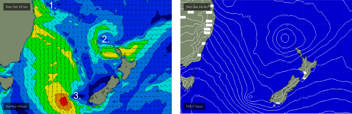
Early next week looks really good for many locations along the East Coast. And this all stems from a complex synoptic chart over the weekend.
A developing low off Northern NSW (see 1 below) will maintain gusty winds locally, whilst another low just north of New Zealand (see 2 below) will have its easterly fetch bisected by the North Island. This will however be another source of swell for our region.
Of greater interest to (mainly) Northern NSW is a third low pressure centre that will develop off the south-western tip of New Zealand’s South Island on Saturday (see 3 below), and track north-west towards Australia's east coast, strengthening S/SE thru’ SE winds that will deliver a strong pulse of S/SE groundwell for Monday.
Monday's wave heights should push upwards of 6ft, maybe 6-8ft at south friendly locations in Northern NSW, with swell direction out of the SE, perhaps a touch of S/SE so expect smaller surf inside southern corners.
More importantly, the swell periods should be nicely drawn out and local winds should steer around to the SW as the low eases and moves away from the coast - both factors of which should improve wave quality markedly from the weekend.
Across SE Qld we’ll see much less size but the semi-exposed points should pick up fun 3ft+ sets and south swell magnets should manage bigger waves in the 4-5ft range.
In addition to this, there’s another round of energy on the way. Strong to gale force easterly winds are expected to develop through the eastern Tasman Sea from Sunday onwards - feeding into the tail end of the same low pressure system responsible for Monday’s S/SE pulse - and they’re looking to generate a strong secondary E/SE swell for Tuesday.
Not all of the models are in agreement with this synoptic situation right now, but I’m comfortable to put something on the table for now - let’s aim for 4-6ft surf in Northern NSW (a food or two smaller in SE Qld) with light offshore winds.
Wednesday will see a steady easing of easterly swells, and early light morning winds ahead of pre-frontal northerlies.
Phew! That’s a lot to digest. Let’s take another look on Friday.
Comments
What’s the forecaster notes word count record?
Classic, count above and I reckon you’ll have the answer!!
Thanks Ben, looking forward to wiping the dust off a board and still holding hope that the southerly action doesn’t completely gutterize the open stretches
Bill Gates pays me by the word.
haha nice one Ben!
WOOOOOOO LETS F'N GO, DROUGHT IS OVER!
Cheers Ben
Thank Christ
Great stuff Ben thanks.
Awesome. Should be plenty of good options around over the next week. Hope y'all get a few
Thx Ben for all details and coast by coast analysis,
Nice forecasting Ben, waves incoming and a food or two for SE Qld. Surfing always makes me hungry.
How's the storms around most of the country.

Frothing! Bought a new set of fins for my good wave (4' plus) board in August last year. Haven't tried 'em yet :)
I bought a good wave board a year ago, I still aint used it
Never use my good wave boards on SC! Just for trips.... haha
Sad but true....
But beautiful place to live...
Bought a new step down a few months ago it's half worn out
Models still jumping around a fair bit. I guess having 3 lows influencing the east coast will do that.
Hope everyone scores wherever they are, been a rough coupla months
So many complicated little fetches forecast- gunna be so interesting to see how all these various swell trains interact in the near-shore zone.
Crazy storm cell just went through the Nth NSW/Southern Goldy area. Hail and strong winds.
Yeh it was wild, then it went sunny and hot AF for a bit and now it's stormy and overcast again!
Clean as now, if only that Nly blew a little harder it would have been one of those perfect little sidewinder arvos.
southerly is thru coffs now
Trying to be positive, but I am ready to be disappointed again.
Southerly blowing mid GC
That southerly hit the goldy at 2pm. I got out as fast as I could when the hail stopped and had perfect 2 foot rainbow runners all to myself for an hour
How good's that! Saw footage from this arvo about an hour before I checked it and there were some clean little barrels about, spewing!
I know ay, i was expecting the change way later around 5 or 6pm ish! So happy to get some waves over the next week with this swell, its been too long
Anyone know what the contest is at Snapper?
It's the Usher Cup.
Unsure what time he's on stage though.
Haha! Boom-tish
Live Stream.
Good waves this morn, not perfect but there were some bloody good nugs coming through!
You north or south of the cape Adsi?
I'm in Ewingsdale mate but i headed south early this morning. Wondered what it was like on the open stretches north of Tyagarah though.
3-4ft surf on the Tweed this morning, lovely clean lines with plenty of push, clean with light offshore winds and sunny skies.
coffs is windy crap.....heard further north around ballina was as you said Ben......
Plenty of size here- 4-5ft at least. Clean until 10am with SW winds.
Still crappy, crappy banks though which made for very mediocre surf.
FR did ya try one of the newbies out or saving it for better days?
You get out on the new whip, Steve?
Not this morning, I rode it this arvo- still some 4-5ft sets around.
man, it felt absolutely magic from wave 1.
True story about the banks Steve, so much potential with swell and conditions but the sand is very poor all round.
Waves are fat and then fading into nothing in the big gaps in the bank.
You would have seen the B-grade spot which has barely a grain of sand anywhere near the rocks.
one wonders, diversion or for real- Mmmm
A day for searching around.
Pretty true what they said for the main breaks but you could hunt random pieces of sand this morning for some fun waves still.
Gotcha
MHL bouy reading 5m south swell @13s coming up the NSW coast Friday arvo. Colour code red.
https://mhl.nsw.gov.au/Station-CRHDOW
Clubbies Snapper comp might need jetski assistance this weekend
Wheres fridays forecast?
Drum roll
Notes are up....ya whining Molls