The coming period will provide plenty of surf days to the east of Melbourne.
Primary tabs
/reports/forecaster-notes/victoria/2025/07/21/easing-surf-plenty-days-the-east
Craig
Monday, 21 July 2025
/reports/forecaster-notes/victoria/2025/07/18/great-surf-today-and-over-the-weekend
Craig
Friday, 18 July 2025
There'll be plenty of opportunities for a surf over the coming days.
/reports/forecaster-notes/victoria/2025/07/16/good-excellent-surf-the-way
Craig
Wednesday, 16 July 2025
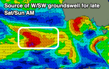
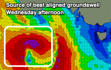
Multiple pulses of large swell are inbound, with favourable winds for the Surf Coast.
/reports/forecaster-notes/victoria/2025/07/14/strong-swells-later-week
Craig
Monday, 14 July 2025
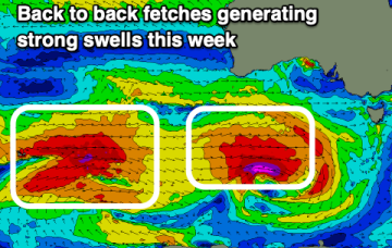
We'll see easing surf over the coming days ahead of back to back, strong groundswells from Thursday through Saturday.
/reports/forecaster-notes/victoria/2025/07/11/great-weekend-larger-surf-likely-later-next-week
Craig
Friday, 11 July 2025
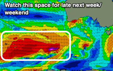
The coming period remains good to great for the Surf Coast, with more energy due later next week.
/reports/forecaster-notes/victoria/2025/07/09/good-run-the-surf-coast
Craig
Wednesday, 9 July 2025
The coming period is fun for the Surf Coast with moderate sized swells, possibly increasing mid-late next week.
/reports/forecaster-notes/victoria/2025/07/07/good-run-moderate-sized-surf
Craig
Monday, 7 July 2025
The Surf Coast will be the pick over the coming period with fun levels of swell and mostly clean conditions.
/reports/forecaster-notes/victoria/2025/07/04/good-couple-days-exposed-breaks-tricky-swells-next-week
Craig
Friday, 4 July 2025
Make the most of the exposed beaches over the coming days with mid-late next week looking tricky and not overly outstanding.
/reports/forecaster-notes/victoria/2025/07/02/fun-surf-friday
Craig
Wednesday, 2 July 2025
Tomorrow will remain average, much better into Friday and the weekend with some fun swell and favourable winds. Longer term is active.
/reports/forecaster-notes/victoria/2025/06/30/mostly-average-week-ahead
Craig
Monday, 30 June 2025
The coming week isn't anything special, especially coming off the recent weekend. Try the beaches later week.