Fun beachy options through the weekend, Surf Coast next week

Victorian Forecast by Craig Brokensha (issued Wednesday April 30th)
Best Days: Exposed beaches Friday, Saturday, exposed beaches Sunday morning, later Monday, Tuesday through Friday Surf Coast
Features of the Forecast (tl;dr)
- Easing mid-period S/SW swell tomorrow with variable winds ahead of sea breezes (S'ly from about Lorne, west)
- Small mid-period SW swell building Fri, peaking in the PM with a stronger SW groundswell Sat AM, easing
- Variable offshore winds Fri AM (NW Surf Coast and N/NE to the east), variable into the PM
- Moderate N/NW-N winds Sat AM, shifting N/NE into the PM
- Fresh N/NE winds Sun
- Moderate + sized, inconsistent W/SW groundswell building strongly Mon PM, peaking overnight, easing slightly Tue
- Reinforcing mod-large W/SW groundswell likely Tue PM/Wed
- Strong N tending N/NW winds Mon
- W/NW tending variable NW Tue
- NW winds Wed
Recap
It’s been a terrible couple of days across the region with strong onshore winds yesterday and some localised windswell, shifting more south-east into today.
This week and next (May 1 - 9)
The trough linked to the current onshore winds is slowly moving east and north and with this we’re now expected to see more variable winds tomorrow morning across the state, tending light E/NE-NE to the east and possibly W/NW from around Lorne to Torquay (lingering S’ly further west).
Swell wise there’s nothing special due with a weak mid-period S/SW swell for today due to ease tomorrow from 2ft on the Surf Coast and 3ft to occasionally 4ft to the east.

On Friday though our new, building mid-period SW swell is due, generated by a strengthening fetch of W/NW gales tracking south-east towards the polar shelf today. This frontal system will actually spawn into a low, with slightly stronger severe-gale W’ly winds due to be generated on its tail with an initial SW swell Friday afternoon due to be followed by a stronger SW groundswell Saturday morning.
We’re looking at the Surf Coast building to a slow 2ft+ through Friday with 4ft sets to the east under variable offshore winds (NW surf Coast and N/NE to the east) ahead of relatively weak if not variable sea breezes.
Saturday morning looks the pick though with 3ft waves on the Surf Coast and 4-5ft surf to the east along with N/NW-N offshore winds in the morning that will shift more N/NE into the afternoon as the swell starts easing.
Sunday will be small to tiny under fresh N/NE winds that will favour exposed breaks, with a low point in energy due Monday morning.
We then look at the strong, long-period W/SW groundswell due to arrive into the afternoon, with a peak likely overnight, if not early Tuesday.
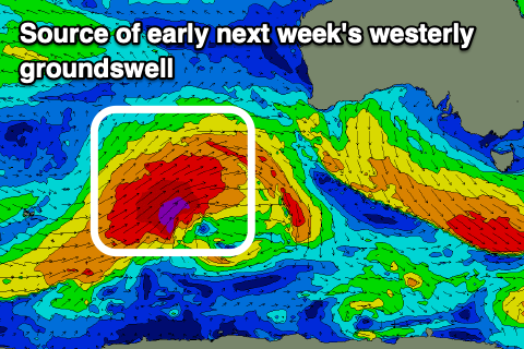
As touched on Monday, a significant polar frontal progression is expected to fire up towards Western Australia later this week, under the influence of a strong node of the Long Wave Trough.
We’re set to see a fetch of severe-gale to storm-force W/SW-SW winds projected through our western swell window, with the strength of the storm being a pro, though the distance from our regions and the westerly angle being a couple of cons.
Regardless, a strong, moderate sized W/SW groundswell is due to build strongly Monday afternoon, likely reaching 3-5ft on the Surf Coast magnets later, peaking overnight and easing from a similar size Tuesday with 6ft+ sets to the east.
Local winds on Monday will be strong out of the N’th, shifting N/NW into the afternoon, with Tuesday seeing a pre-dawn W/SW-SW change that’s due to ease and leave variable W/NW-NW winds through the day.
This change will be linked to a secondary, closer projecting frontal system towards us early next week, generating an additional, moderate-large sized W/SW groundswell for later Tuesday/Wednesday.
The models diverge a little regarding this follow up activity but we’re looking at multiple moderate-large sized swells from Wednesday through Friday under a general north-westerly flow. More on this Friday.
Comments
Monday to Wednesday next week look good.
:-)