Indonesia/Maldives forecast Jul 1

Indian Ocean Basin analysis by Craig Brokensha (issued Tuesday 2nd July)
This week through next (July 2 - 11)
Our large swell over the weekend came in nicely, with an easing trend seen into the start of the week.
Later today but more so tomorrow, some inconsistent, moderate + sized SW groundswell is due to fill in, but not to the size that the models are showing, with them incorrectly combining.
The swell should peak tomorrow morning before easing into the afternoon, further Thursday morning.
Later in the day Thursday and Friday morning, an acute, inconsistent S/SW groundswell is due, generated off a late forming and tight polar low that developed east of the Heard Island region over the weekend.
Only moderate sized sets are due from this source, with the models again incorrectly combining swell trains.

Apart from another moderate sized, inconsistent SW groundswell for later Monday/Tuesday from a distant polar low forming well south of Madagascar yesterday, we’ve got a much juicer outlook for mid-late next week.
Just quickly though, the Mentawais will see a larger SW groundswell early next week, produced by a strong mid-latitude low that will spawn south-east of Madagascar tomorrow (left), aiming a meridionally aligned fetch of gale to severe-gale S-S/SW winds mostly towards the Maldives, with large levels of SW groundswell spreading out radially towards the Mentawais, peaking Monday. This swell will be poorly aimed for eastern Indonesia.
Coming back to the larger stuff due through the week, and a strong node of the Long Wave Trough is expected to form across Western Australia, bringing with it a significant, northward projecting cold outbreak through the weekend and early next week.

At this stage wind strengths aren’t overly significant but the broad, northward projection should generate a large mix of consistent S/SW swells for later Wednesday/Thursday next week. Check back Thursday for the latest outlook on how the size is shaping up.
Local, strong E/SE trades are due to persist tomorrow, shifting SE on Thursday before easing a little over the weekend, re-strengthening from the E/SE next week. Local, light offshore winds are due every morning.
In the Mentawais the swell for later next week will come in more south and a little smaller though still on the large scale.
Variable winds are due this period, tending SE at times across southern locations Thursday/Friday and possibly early-mid next week.
----------------------------------------------
Maldives:
Later yesterday, building levels of moderate + sized S/SE trade-swell should have been seen across the region, peaking through today before easing tomorrow thanks to the swell generating trades south of us relaxing. These trades will continue to weaken over the coming days, resulting in the S/SE swell to continue to ease though the week ahead of larger S/SW groundswell into the weekend.
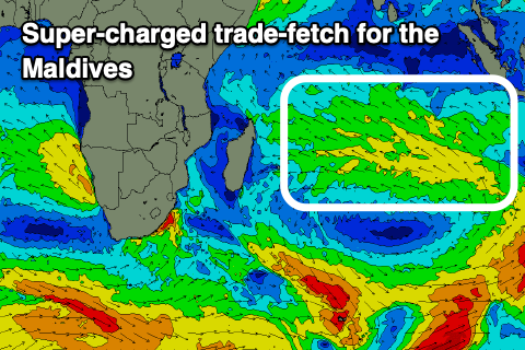
This swell will be generated by the strong mid-latitude low forming south-east of Madagascar over the coming days, with a great fetch of gale to severe-gale S/SW winds due to be projected ideally towards us.
We’ll see a moderate sized mid-period swell for Saturday, with the groundswell peaking Sunday, easing slowly Monday.
As this swell eases, a great fetch of strengthening SE trades are again to form south of us into Sunday, broadening and expanding east through next week.
This will generate moderate to large levels of building S/SE tending SE trade-swell through next week, peaking later week before easing slowly into next weekend.
Our weak, local winds are due to increase from the S tending S/SE a touch across southern atolls over the coming days, with W/SW breezes to the north, similar through the weekend though with winds tending more SE to the south.
We may see fresher SE winds early next week across southern locations before weakening thereafter.
Eastern Indonesia:
Moderate + sized mix of SW swells for later today, peaking tomorrow morning to 6ft across exposed breaks, easing thereafter.
Inconsistent, moderate sized S/SW groundswell for later Thursday and Friday morning to 4ft+ across exposed breaks.
Inconsistent, moderate sized SW groundswell for Monday afternoon and Tuesday morning to 4-5ft+ across exposed breaks.
Large mix of mid-period and groundswell building Wednesday, peaking Thursday.
Strong E/SE trades tomorrow, shifting SE on Thursday before easing a little over the weekend, re-strengthening from the E/SE next week. Local, light offshore winds are due every morning.
Uluwatu 16-day Forecast Graph/WAMs
Western Indonesia/Mentawais/South Sumatra:
Moderate to large mix of SW groundswells peaking today to Tuesday to 6ft+ across exposed breaks, easing later and further tomorrow.
Smaller later week and into the weekend.
Moderate to large sized SW groundswell for Monday to 6ft+ across exposed breaks, easing Wednesday.
Large S’ly swells for later next week (Thursday).
Variable winds this period, tending SE at times across southern locations Thursday/Friday and possibly early-mid next week.
Mentawai 16-day Forecast Graph/WAMs
Maldives:
Moderate + sized S/SE trade-swell easing from tomorrow morning, further into the end of the week.
Moderate sized mid-period S/SW swell building Saturday, peaking into the afternoon to 4-5ft across southern locations, smaller Male.
Large S’ly groundswell Sunday, peaking to 5-6ft across the southern atolls, smaller Male.
Super-charged S/SE tending SE trade-swell building through next week, peaking later.
Moderate W/SW-W winds across northern locations most of the period, weak S-S/SE to the south, increasing from the SE early next week, then variable.
Comments
Latest notes are live.
Those models had me fooled today, was expecting overhead to possibly double overhead. Unfortunately head high was it , couple just bigger . Tomorrow morning may be on maybe not .