Improving surf late week

Victorian Forecast by Craig Brokensha (issued Monday April 28th)
Best Days: Exposed beaches Friday and Saturday, next Wednesday onwards
Features of the Forecast (tl;dr)
- Strenthenning S/SW tending S winds tomorrow with a weak local S windswell
- Small-mod sized mid-period S/SW Wed with fresh E/SE winds, shifting SE and strengthening
- Small Thu with moderate E/SE tending S/SE winds
- Small SW swell building Fri, peaking in the PM, easing Sat
- E/NE tending SE winds Fri, local offshore Sat, tending NE into the PM
- Tiny surf Sun/Mon with fresh N/NE winds
- Moderate sized W/SW groundswell for next Wed
Recap
In general it was a poor weekend of surf across the state with freshening onshore winds both days and building levels of SW swell energy that pushed in strong late Saturday, holding Sunday morning. There was a window of more variable winds east of Melbourne Saturday morning but otherwise quality was hard to come by.
This morning winds are still lingering onshore and the swell is on the decline with not much quality to be found.
This week and weekend (Apr 29 - May 4)
The coming days unfortunately look mostly wind affected and average as a secondary Southern Ocean trough moves up and replaces the system that brought the onshore winds for the weekend just past.
This will see strengthening S/SW tending S’ly winds tomorrow, switching E/SE into Wednesday morning but remaining fresh (strengthening SW into the PM) as high pressure starts to move in from the west.
Swell wise there’s nothing of any real note with some poor, localised S’ly windswell tomorrow and some small mid-period S/SW energy for Wednesday.
Expect surf in the 3ft range across the Surf Coast with 4ft+ waves to the east.
The swell is due to ease into Thursday morning as winds relax a little more and shift E/SE, with periods of E’ly breezes likely at times east of Melbourne.
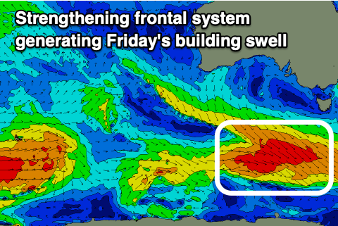
It won’t be until Friday morning that we see winds shift more E/NE-NE across the region, cleaning up the beaches along with a small to moderate sized, building mid-period SW swell.
The source will be a strengthening frontal system projecting towards the polar shelf, generating a fetch of strengthening W/NW winds that will reach gale-force late in our swell window.
The swell should build through the day and reach 2ft to occasionally 3ft on the Surf Coast and 4-5ft sets likely to the east into the afternoon, easing Saturday from a slightly smaller size.
Local offshore winds are due on Saturday morning (N/NW to the west and N/NE to the east) ahead of NE winds into the afternoon.
The swell will bottom out under fresher N/NE winds Sunday/Monday, with a significant mid-latitude frontal progression forming south-west of Western Australia.
We’re set to see a significant polar front projecting north-east towards Western Australia, breaking down while pushing east through the weekend, though secondary systems will fire up in its wake, pushing closer towards us through the weekend and early next week.
This will result in building levels of moderate + sized westerly groundswell that looks to push in from mid-next week. Winds also look favourable but we’ll have a closer look at this over the coming week.
Comments
April 85th...far out, it's been a big month!
Love your work Craigos :)
Ha!