Very small and inconsistent SW swell for tomorrow with N/NW winds ahead of an afternoon SW change. Tiny and onshore Friday. New mix of swells building Saturday with less than ideal winds, cleaner as the swells ease Sunday.
Primary tabs
/reports/forecaster-notes/victoria/2016/04/20/average-end-week-fun-sunday-and-cleaner-next-week
Craig
Wednesday, 20 April 2016
/reports/forecaster-notes/victoria/2016/04/18/easing-clean-surf-average-end-week
Craig
Monday, 18 April 2016
Gradually easing surf with good winds for more exposed breaks tomorrow and Wednesday. Average small waves to end the week.
/reports/forecaster-notes/victoria/2016/04/15/average-weekend-solid-sunday-clean-and-easing-next-week
Craig
Friday, 15 April 2016
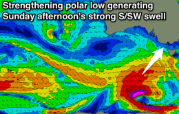
Small onshore waves tomorrow, with a strong new S/SW groundswell filling in Sunday but with S/SE winds. Cleaner as it eases Monday, straighter from Tuesday.
/reports/forecaster-notes/victoria/2016/04/13/fun-waves-end-week-average-weekend-plenty-swell
Craig
Wednesday, 13 April 2016
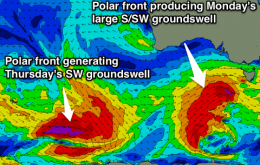
New inconsistent swell for tomorrow, best east of Melbourne and on the Surf Coast beachies, clean both coasts with an easing swell Friday. Onshore all weekend with a strong mix of swells building Sunday, easing Monday with improving conditions.
/reports/forecaster-notes/victoria/2016/04/11/torquay-early-tomorrow-both-coasts-thursday
Craig
Monday, 11 April 2016
Good easing swell tomorrow with early W'ly winds around Torquay, onshore elsewhere, smaller and onshore Wednesday. New inconsistent SW swell for Thursday with good winds, easing Friday and clean again.

/reports/forecaster-notes/victoria/2016/04/08/great-surf-coast-tomorrow-and-sunday-large-monday-dicey
Craig
Friday, 8 April 2016
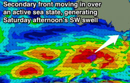
Building SW groundswells with offshore winds for the Surf Coast, easing back Sunday morning and remaining clean. New swell later in the day, peaking Monday but with less than ideal winds. Good strong swell Thursday morning with decent winds for the beaches.
/reports/forecaster-notes/victoria/2016/04/06/great-period-surf-coast
Craig
Wednesday, 6 April 2016
Easing mix of swells with clean conditions on the Surf Coast tomorrow, smaller and remaining clean Friday. Good mix of new swells building Saturday with favourable winds for both coasts, easing Sunday with strengthening NW winds ahead of a strong onshore change. Plenty more swell next week but not as clean.
/reports/forecaster-notes/victoria/2016/04/04/good-both-coasts-tomorrow-morning-surf-coast-thereafter
Craig
Monday, 4 April 2016
Easing swell with fresh N'ly tending NW winds tomorrow ahead of a late onshore change. Building mix of swells Wednesday cleanest west of Melbourne. Great weekend on the Surf Coast.

/reports/forecaster-notes/victoria/2016/04/01/large-sunday-decent-winds-cleaner-and-easing-next-week
Craig
Friday, 1 April 2016
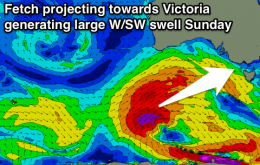
Strong building W/SW swells tomorrow with average conditions, large and peaking Sunday morning with a morning W/NW breeze on the Surf Coast. Easing swell into Monday and Tuesday with favourable winds.
/reports/forecaster-notes/victoria/2016/03/30/looking-great-friday-and-good-again-sunday
Craig
Wednesday, 30 March 2016
Clean Surf Coast tomorrow with a new swell for the afternoon, excellent Friday with a strong new swell and offshore winds. Large mix of swells building through Saturday with average winds, peaking Sunday with variable tending W/NW winds.