Generally average period with limited windows of clean conditions

Victoria Forecast by Craig Brokensha (issued Friday 22nd January)
Best Days: Keen surfers Saturday and Sunday mornings around Torquay, east of Melbourne Wednesday morning
Recap
A good kick in swell yesterday to 3-4ft on the Surf Coast and 6ft to occasionally 8ft on the Mornington Peninsula with workable light to moderate SE winds for keen surfers. A drop in size was seen into the afternoon, but today a new reinforcing SW pulse has kept similar if not slightly smaller waves hitting both regions with fluctuating winds.
Early variable breezes were spoilt by a storm moving through both regions, bringing fresh but short-lived onshore winds. Conditions have since improved again with variable tending light offshore winds across most locations, well worth a surf.
This weekend and next week (Jan 21 - 29)
Today's reinforcing SW groundswell will ease off gradually through the weekend (steadying Sunday with a small reinforcing W/SW swell) and for the most part conditions will be average with fresh SW winds tomorrow and SW tending S/SW winds Sunday.
Each morning there's a chance that the Torquay region will see W'ly breezes with easing 3ft sets on the Surf Coast, back to 2ft on Sunday, with 4-5ft+ waves on the Mornington Peninsula, down to 4ft or so Sunday.
Into Monday a new small mid-period SW swell is due, keeping 2ft sets hitting the Surf Coast and 3-4ft waves on the Mornington Peninsula, but fresh S'ly winds will leave no options for a decent wave.
More variable breezes may be seen Tuesday morning but with a small easing swell. We'll have a closer look at this Monday as the models are still divergent on the axis of a surface trough around the region.
 Variable winds are much more likely Wednesday morning, but the Mornington Peninsula will be the only decent option with small easing 3ft to possibly 4ft sets early.
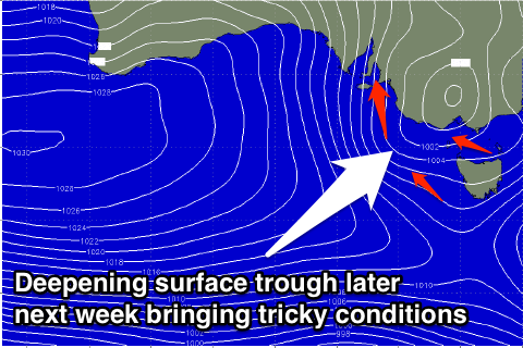
Into the end of the week a mix of small to moderate W/SW groundswell and building SE windswell are due across the coast, the later generated as a inland surface trough deepens across the state and starts moving east towards the Tasman Sea.
With this tricky system in the region, it's not worth going into the details of the coming swell as winds may write-it off and the specifics are too hard to nail down at the moment. Check back Monday for a clearer idea, and have a great weekend!