Strong W/SW swell tomorrow but onshore, best Saturday

Victoria Forecast by Craig Brokensha (issued Wednesday 3rd February)
Best Days: Both coasts from mid-morning Saturday, keen surfers east of Melbourne Sunday morning
Recap
Small, clean but tiny waves yesterday across the Surf Coast with better 2-3ft sets on the Mornington Peninsula. Today a weak onshore was seen early with small to tiny amounts of swell, and freshening winds will deteriorate conditions further through the day.
This week and weekend (Feb 4 - 7)
Later today a strong increase in W/SW groundswell is due, peaking through tomorrow across the Victorian coastline. This was produced by a vigorous mid-latitude low under WA, generating a fetch of severe-gale to storm-force W/SW winds through our western swell window.
The low has since moved east through the Bight and is now tracking south-east while weakening, but a new fetch of SW gales has formed on its tail, which will persist through our swell window today before moving out of our swell window tomorrow.
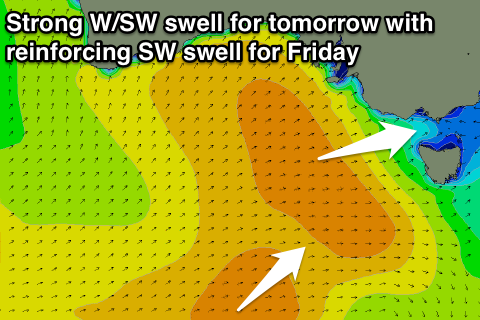 What will result is a strong pulse of W/SW groundswell for tomorrow to 3-4ft across exposed breaks on the Surf Coast, with 5ft bombs at swell magnets, while the Mornington Peninsula should come in at 6-8ft.
This swell should ease back into tomorrow evening, to be replaced by a new pulse of SW groundswell filling in Friday, from the fetch of SW gales to our south-west.
3ft+ sets should be seen across the Surf Coast from mid-morning onwards, with 6ft surf on the Mornington Peninsula before easing from 2-3ft and 4-6ft Saturday morning respectively.
A small reinforcing SW is expected Saturday afternoon/Sunday morning from a weak fetch of W/NW winds through our south-west swell window. 2ft sets should continue on the Surf Coast with 3-4ft waves on the Mornington Peninsula, fading into Monday.
Now, unfortunately the wind outlook for Thursday and Friday is poor with a fresh and gusty S'ly tending S/SE breeze due through tomorrow, persisting from the SE on Friday.
The start of the weekend is looking fun across the beaches across both regions with an E/NE tending N/NE breeze due Saturday morning ahead of SE sea breezes, while Sunday is a little dicey with variable breezes from the SE likely. We'll have a closer look at this Friday.
Next week onwards (Feb 8 onwards)
Small easing surf and onshore breezes are due into Monday next week, but some fun pulses of SW groundswell are due from Tuesday afternoon through Thursday. These swells will be produced by weak frontal systems moving in from the Indian Ocean, but a weak high pressure ridge is expected to aim persistent weak S'ly winds across the coast. Therefore make the most of the weekend's waves!
Comments
How does one paste photos in the comment section?
https://www.swellnet.com/forums/wax/96181
http://imgur.com/a/bHcrV
Im not sure if this works and if it does cheers and thus leads me to my next question.
How do buoys go from picking up mid peroid swell then literally verticall declining to junk swell (6s) to increasing vertically to a strong period swell?
I can hardly imagine theres this big chopped up ocean then all of a sudden these strong lines of swell just cruise on through. Or is that exactly how it happens? Surely there has be some sort of shallower gradient than vertical?
That would be maintenance or an issue with the buoy . Most likely batteries , as CDC had a similar issue recently .
Bone nick do u mean the current buoy readings for example ? Cdc & sorr
Yes. Well the within the last 24 hours. Two huge spikes yesterday around 8am and 4pm.
Period data does look a little suss.
You usually see a drop in period like that from 12s to 5s when a strong cold front pushes through kicking up short-range windswell, but the change moved through at 4am at Cape Sorell, well before that drop.
Then you see the periods climb back as the stronger groundswell fills in, but usually it bounces between the 5s and say 18s, not just rocket back up.
All fine now though.
Yes nickb I guessed that , I see it too , its a common thing for the graph to plunge to 5secs often just as a big period starts to arrive . And id like to understand that too
Nick B.
Ocean swells are a lot like women -just before the big period arrives, they can get a bit short and difficult to understand.
Spoken like a true Gary, @Adam12.