Workable waves tomorrow and Friday, clean and fun Saturday morning

Victoria Forecast by Craig Brokensha (issued Wednesday 10th February)
Best Days: Keen surfers Thursday and Friday mornings, Saturday morning both coasts, Monday morning Surf Coast
Recap
Average small waves yesterday with weak onshores through the morning, increasing from the S'th through the day.
Today a good new fun SW groundswell is providing 3ft sets across the Surf Coast and 5ft on the Mornington Peninsula with light variable winds (from the SW) creating fun waves for keen surfers across both regions. Winds have since picked up, creating deteriorating conditions.
This week and weekend (Feb 11 - 14)
Today's fun pulse of SW groundswell is expected to ease back into tomorrow, bottoming out Friday morning.
Exposed breaks on the Surf Coast should ease from 2-3ft, with 3-5ft sets on the Mornington Peninsula. Winds will linger from the south creating not perfect but workable conditions tomorrow morning, similar in strength Friday morning and possibly even tending variable through the morning but from the SE.
Into Friday afternoon a new SW groundswell is due, generated by a relatively weak polar front that's pushed in from the south-east Indian Ocean and is far south-west of us this morning.
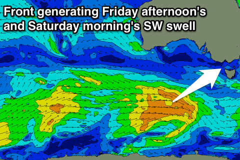 Another fun kick to the 3ft range on the sets is due Friday afternoon on the Surf Coast, 4-5ft+ on the Mornington Peninsula with weak SE sea breezes, easing from 2-3ft and 4-5ft Saturday morning.
Conditions are looking great Saturday morning as well with local morning offshores across both coasts, tending W/NW ahead of an afternoon SW change.
Onshore winds will persist from the SW into Sunday morning, and our 'bombing low' is still expected to form to our south-west but its structure is relatively poor along with a south-east track.
This has resulted in a slight downgrade on the expected size due Sunday afternoon, with messy 3-4ft surf due to develop on the Surf Coast and 6ft+ sets on the Mornington Peninsula.
Into next week a series of relatively weak but favourably located frontal systems should produce fun amounts of SW swell for most of the week, with favourable W/NW winds for the Surf Coast Monday morning, onshore into Tuesday as a new ridge of high pressure moves in from the west. More on this Friday though.