Plenty of swell to end the week but with dicey winds

Victoria Forecast by Craig Brokensha (issued Wednesday 20th January)
Best Days: Thursday keen surfers both coasts, Friday morning both coasts, Torquay early Saturday
Recap
Light variable winds yesterday morning from the western quadrant favoured the Surf Coast over the Mornington Peninsula with small 1-2ft waves and bigger slightly bumpy waves to the east.
Today winds were again light and variable, but more from the eastern quadrant creating clean fun but small 2-3ft waves on the Mornington Peninsula with a continuation of inconsistent 1-2ft sets on the Surf Coast.
This week and weekend (Jan 21 - 24)
There's been no change to tomorrow's good kick in SW groundswell with a polar frontal progression generating a moderate sized SW swell that should kick later today and peak around 3-4ft tomorrow on the Surf Coast and 6ft to possibly 8ft on the Mornington Peninsula.
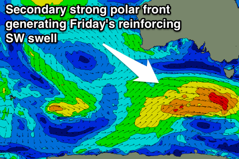 Our secondary reinforcing SW groundswell for Friday is also on track with a secondary vigorous polar front currently firing up south-west of us, keeping 3ft+ sets hitting the Surf Coast, with 6ft+ waves on the Mornington Peninsula.
Our dicey wind outlook for tomorrow is unfortunately still so, with a lingering and light to moderate SE'ly expected to the be fly in ointment across both coasts. In saying this keen surfers should still find fun workable waves at selected breaks.
Friday is looking a little better but still a touch dicey with more variable breezes from the east. With this in mind keep an eye on your local observations for an idea on where to surf for the best conditions.
Into the weekend, a gradual easing trend is expected, slowed through Sunday but a small reinforcing SW swell.
The Surf Coast should ease from 3ft on the sets Saturday morning, down from a smaller 2ft Sunday, with 4-5ft+ waves on the Mornington Peninsula, down from 3-4ft or so Sunday.
Unfortunately winds are looking average for most of the weekend, with a moderate to fresh SW'ly Saturday, weaker from the S/SW Sunday. The Torquay region is likely to see early W'ly breezes Saturday morning and less so Sunday morning, but check back here Friday for a greater idea surrounding this.
Next week onwards (Jan 25 onwards)
A slow moving high pressure ridge drifting in from the west will keep persistent onshore winds blowing into both coasts through most of next week with minimal amounts of swell. A shift in winds may be seen later in the week, but we'll have another look at this Friday.
With this in mind it's probably worth making the most of the swell and less than ideal conditions expected tomorrow and Friday.
Comments
Hi Craig
How you feeling about the dicey winds in the morning. It's looking like we'll get some North in it???
Thanks
Looking a very good chance of variable winds for most of the morning now, which is great. And also a decent chance for a very light NE'ly on the Mornington Peninsula.
Cheers
An early storm moving through the region brought in fresh onshores which is a bugger, conditions are improving on the backside though with offshore E/NE winds. So tricky with these troughs and funky weather.
Didn't bother with it. Last night it didnt feel like it was gunna go North enough for where l'm interested in.
Looking at BOM wind observations now at I think l may have made a blew...
Hmmm