Small swells and varying winds

Victoria Forecast by Craig Brokensha (issued Monday 25th January)
Best Days: Wednesday both coasts from mid-morning, early Thursday desperate surfers east of Melbourne, Friday afternoon east of Melbourne, Saturday morning both coasts
Recap
Average onshore and easing surf across all locations besides the Torquay region which offered the most workable conditions with lighter early W/SW breezes.
This morning a straight onshore and smaller swell have left the coast a terrible mess.
This week (Jan 26 - 29)
We've got better conditions forecast for the coming week ahead, but the only issue is swell.
A small mid-period SW swell should keep inconsistent 2ft sets hitting exposed beaches on the Surf Coast with 3-4ft waves on the Mornington Peninsula but with fresh and strengthening E/SE winds. This will create poor conditions while also kicking up some SE windswell across the Surf Coast to 2-3ft later in the day.
Into Wednesday a mix of easing SE windswell and SW swell from 2ft+ on the Surf Coast and 3ft on the Mornington Peninsula are due with improving conditions through the morning.
The axis of the surface trough across the state should shift to the west, resulting in winds swinging offshore from the NE to N/NE through the morning, creating the best conditions mid-late morning. Winds are likely to hold from the NE all day, favouring the beaches across both regions.
 Into Thursday the swell will bottom out and an approaching front will bring early N/NW winds ahead of a W/SW change. Hit the Mornington Peninsula early if you're desperate for the odd 2ft set.
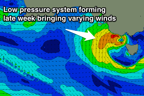
Thursday's change will be linked to a a weak front shedding off a stronger polar low that's currently south-west of WA.
The front itself is expected to be absorbed into the surface trough on Friday, with a weak increase in windswell for Friday ahead of better inconsistent groundswell from the low Saturday.
Small 1-2ft sets are due Friday on the Surf Coast and 3ft on the Mornington Peninsula with NW tending N/NE winds as the trough forms into a broader low pressure system. The low is likely to shift slightly south-east Saturday with the new groundswell bringing NE to SE winds, with inconsistent 2-3ft sets on the Surf Coast and 4-5ft waves on the Mornington Peninsula.
Easing surf is then due into Sunday with westerly winds and nothing significant size wise until mid-late next week. More on this Wednesday though.