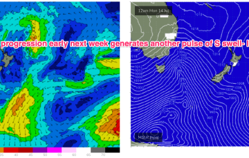
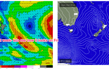
That will lead to elevated surf from the SE-E for most of next week with just a very slow, gradual tapering off as the fetch slowly weakens while remaining basically semi-stationary.
Primary tabs
/reports/forecaster-notes/south-east-queensland-northern-new-south-wales/2025/07/30/extended-large
freeride76
Wednesday, 30 July 2025
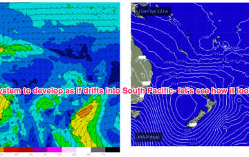
/reports/forecaster-notes/south-east-queensland-northern-new-south-wales/2025/07/28/bit-and-pieces
freeride76
Monday, 28 July 2025
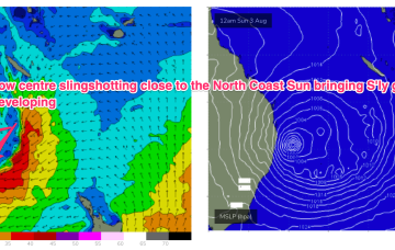
There’s broad model agreement now for a low to form off the sub-tropical coast and merge with a Coral Sea low pressure centre, deepening explosively through Sat and into Sun.
/reports/forecaster-notes/south-east-queensland-northern-new-south-wales/2025/07/25/spell-small-surf
freeride76
Friday, 25 July 2025
Inshore we’ll see those winds between 10-15 kts through the morning tending stronger N’ly through the day and generating small NE windswells for the MNC up to Yamba, not much further north of there.
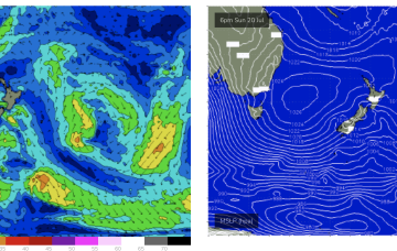
/reports/forecaster-notes/south-east-queensland-northern-new-south-wales/2025/07/23/mix-swells-ahead
freeride76
Wednesday, 23 July 2025
During this time frame a retreating but broad and long trade fetch will be supplying some background E’ly pulses.
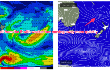
/reports/forecaster-notes/south-east-queensland-northern-new-south-wales/2025/07/21/ely-swell
freeride76
Monday, 21 July 2025
Unfortunately, compared to Fridays expectations the interplay between these two systems is weaker, with a more constrained fetch of lower windspeeds that drifts away quicker than modelled on Friday. That will result in smaller east quadrant swell this week, relative to Fridays expectations.
/reports/forecaster-notes/south-east-queensland-northern-new-south-wales/2025/07/18/extended-ely
freeride76
Friday, 18 July 2025
There’s still some model divergence later next week but for now we’ve got reasonable confidence a broad fetch will develop through the Northern Tasman as high pressure moves into the Tasman and supplies an anchor for the low.
/reports/forecaster-notes/south-east-queensland-northern-new-south-wales/2025/07/16/out-season-east
freeride76
Wednesday, 16 July 2025
We'll see plenty of surf surf from this system initially but there is broad model agreement we’ll see this low deepen and develop into a more powerful system mid/late next week as it drifts into a position north of the North Island. Best case scenario is a quality E’ly groundswell event from this system.
/reports/forecaster-notes/south-east-queensland-northern-new-south-wales/2025/07/14/fun-beachbreak
thermalben
Monday, 14 July 2025
A strong front pushed into off the NSW coast the Tasman Sea overnight, and it’s generating a flush of south swell that’ll fill in this evening and provide a nice boost in surf size across Northern NSW on Tuesday.
/reports/forecaster-notes/south-east-queensland-northern-new-south-wales/2025/07/11/combination
freeride76
Friday, 11 July 2025
We’ll see some nice S pulses over the weekend as multiple fetches operate on an active sea state. Favouring NENSW for size, with small background E swell padding out surf zones in SEQLD.
/reports/forecaster-notes/south-east-queensland-northern-new-south-wales/2025/07/09/background-e
freeride76
Wednesday, 9 July 2025
Compared to Mondays notes the outlook for S swell is improved, mostly due to a better aligned following front which conjoins the initial front and forms a slower moving low in the southern Tasman.