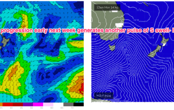
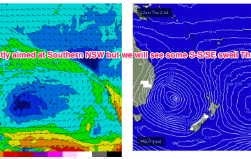
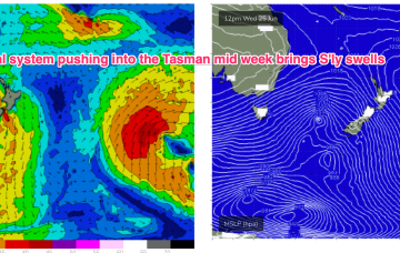
Compared to Mondays notes the outlook for S swell is improved, mostly due to a better aligned following front which conjoins the initial front and forms a slower moving low in the southern Tasman.
Primary tabs
/reports/forecaster-notes/south-east-queensland-northern-new-south-wales/2025/07/09/background-e
freeride76
Wednesday, 9 July 2025
/reports/forecaster-notes/south-east-queensland-northern-new-south-wales/2025/07/07/wly-pattern-week
freeride76
Monday, 7 July 2025
High pressure is well up over the centre of the continent with as weak, troughy area of low pressure moving offshore from the south coast dragging a cloud band with it and offering a W’ly flow in it’s wake. That W’ly flow looks to continue through the working week as a series of cold fronts sweep across the SE of the country.
/reports/forecaster-notes/south-east-queensland-northern-new-south-wales/2025/07/04/s-swells-easing
freeride76
Friday, 4 July 2025
The complex, coastal low is now dissipating and drifting towards New Zealand while high pressure drifts NE to sit over sub-tropical NSW/SEQLD tomorrow before entering the Tasman on Sunday with a broad low pushing across the interior of Victoria and NSW behind it.
/reports/forecaster-notes/south-east-queensland-northern-new-south-wales/2025/07/02/easing-the-e-some
freeride76
Wednesday, 2 July 2025
Gales to severe gales from the S through SE will generate another large peak in size later today and through tomorrow from the secondary low slingshotting around the primary centre, focused on Southern/Central NSW with a much smaller payload being delivered north of the Hunter.
/reports/forecaster-notes/south-east-queensland-northern-new-south-wales/2025/06/30/ely-swells-tap
freeride76
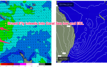
Monday, 30 June 2025
A Coral Sea trough deepens into a small low and becomes continuous with a NSW coastal trough which deepens today and forms an ECL over the next 12-24hrs. By first light tomorrow morning and ECL or variant thereof will be positioned off the lower end of the MNC, likely due east of Seal Rocks.
/reports/forecaster-notes/south-east-queensland-northern-new-south-wales/2025/06/27/fun-waves-over
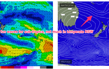
freeride76
Friday, 27 June 2025
Through Mon both the coastal and Coral Sea troughs deepen with a strong and broad E/NE-NE infeed into a developing surface low (possibly some variant of ECL) late Mon o/night into Tues.
/reports/forecaster-notes/south-east-queensland-northern-new-south-wales/2025/06/25/sizey-the-s
freeride76
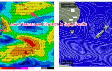
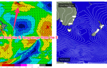
Wednesday, 25 June 2025
In the eastern swell window a massive high east of New Zealand and tropical depression in Tongan longitudes is reaching peak intensity and expected to send some meaningful E’ly groundswell towards the eastern seaboard, making landfall over the weekend and next week.
/reports/forecaster-notes/south-east-queensland-northern-new-south-wales/2025/06/23/long-range-swells
freeride76
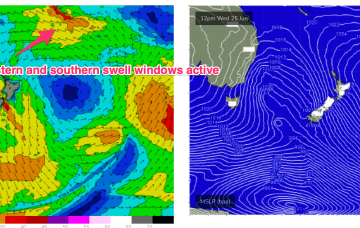
Monday, 23 June 2025
A retreating trade fetch gets supercharged by a developing trough and low in the South Pacific, reaching maximum intensity between Tongan and Tahitian longitudes. Despite the travel distance, we should see some quality long range E swell from this source, with some size from the south this week as the front and low traverse the Tasman.
/reports/forecaster-notes/south-east-queensland-northern-new-south-wales/2025/06/20/fun-round-winter
freeride76
Friday, 20 June 2025
High pressure across the interior of NSW will be moving across Southern NSW into the Tasman, with a trade fetch currently anchored by a small low sliding off to the SE over the weekend.
/reports/forecaster-notes/south-east-queensland-northern-new-south-wales/2025/06/18/fun-round
freeride76
Wednesday, 18 June 2025
There is a trough in the Coral Sea with an associated cloud band which is expected to play a role in focussing Tradewinds which form up later this week on the back of a SE surge.