Tricky, average outlook

Victorian forecast by Craig Brokensha (issued Monday January 13th)
Best Days: This morning, early Wednesday to the east, Monday morning, Tuesday morning
Features of the Forecast (tl;dr)
- Easing swell tomorrow with light-mod S winds, freshening into the PM
- Small-mod sized, inconsistent W/SW groundswell building slowly Wed, strongest later and peaking Thu AM
- Fresh N/NE winds early Wed AM, shifting W/NW mid-late AM ahead of a stronger SW'ly into the PM
- Moderate sized W/SW-SW swell Thu with strong SW tending S/SW winds Thu
- Easing surf Fri with fresh S/SW winds
- Strong E tending SE winds Sat/Sun with small-mod levels of SE windswell
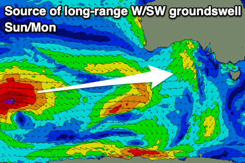
- Moderate sized, inconsistent W/SW groundswell building Sun PM, peaking Mon
- Lighter E/NE winds developing Mon and Tue AM, strong SE into the PM
Recap
Saturday didn’t offer much in the way of size with light winds across all locations through the morning ahead weak sea breezes, while yesterday our good but inconsistent W/SW groundswell was in the water, building under light winds.
The Mornington Peninsula was fogged in most of the morning with sets to 4ft, building further through the day while to the west, early light winds only tended light onshore as the swell kicked to a fun 3ft+ through the afternoon.
This morning the swell is slowly easing with inconsistent sets to 3ft on the Surf Coast and 4-5ft to the east under variable morning winds.

New swell yesterday AM

New swell yesterday PM with light winds
This week and weekend (Jan 14 - 19)
We’ve got a similar wind outlook for tomorrow morning across the region as the current swell continues to ease under a light to moderate S’ly breeze that may tend variable for periods before increasing slightly through the afternoon.
The Surf Coast looks to ease back from a slow 2ft with 3-4ft sets to the east, smaller again into early Wednesday morning.
This low point will only be short-lived, with a new, long-range W/SW groundswell due to build through the day, peaking Thursday morning.
The source was a strong low that formed to the south-east of South Africa last week, with it projecting east while generating significant fetches of gale to storm-force winds. The low has since broken down with the remnants projecting towards Western Australia today, and we should see the long-period, inconsistent groundswell building through Wednesday, likely reaching 2ft+ on dark across the Surf Coast and 4-5ft to the east.
Winds will be quite dynamic on Wednesday as a trough moves across us with fresh, morning N/NE winds due to shift W/NW by mid-late morning and then stronger W/SW-SW into the late afternoon.
The trough itself should bring with it some new mid-period W/SW swell for Thursday, with a tight fetch of sub-gale-force W/SW winds due to be projected through Bass Straight Wednesday afternoon and evening.
A weak 3ft of swell is due on the Surf Coast and 4-6ft to the east (mixed with the long-range W/SW groundswell) but with strong SW winds persisting in the wake of Wednesday’s change, shiting S/SW through the day.
Now, this trough is still expected to aid the formation of a deep low in the Tasman Sea over the weekend but the position looks a bit further north, resulting in S/SW winds through Friday that will then shift E-SE on Saturday and strengthen as the lows axis shifts back further south.
We’re then looking at similar winds Sunday, a little better early-mid next week as the low remains near stationary in the southern Tasman Sea before weakening and releasing its grip on our region mid-late next week.
This will bring persistent levels of small to moderate sized SE windswell to the Surf Coast, while there’s also due to be some moderate sized, inconsistent W/SW groundswell in the mix from Sunday afternoon/evening through Monday/Tuesday.
The source is another strong frontal progression in our far swell window, south of the Indian Ocean. This progression will project multiple fetches of gale to severe-gale winds through our long-range swell window and should produce inconsistent 3ft sets on the Surf Coast at its peak Monday with 4-6ft waves to the east.
Longer term the outlook is too dynamic and unpredictable to nail down so check back Wednesday.
Comments
forey looks fucked craigos, this the start of La Nina? Sell the summer quiver and take up a new hobby?
Take up bouldering