Fun early next week before another poor setup establishes

Victorian Surf Forecast by Craig Brokensha (issued Wednesday 26th January)
Best Days: Today exposed beaches, Monday morning, Tuesday morning
Features of the Forecast (tl;dr)
- Tiny surf over the coming days with gusty N/NE winds tomorrow, easing later and light N tending S/SW winds Fri
- Mod-fresh S winds Sat with tiny surf
- Inconsistent W/SW groundswell building Sun, peaking into the PM with moderate E/SE tending fresh S/SE winds
- Easing W/SW groundswell Mon with light-mod E/NE-NE winds ahead of S/SE sea breezes
- Smaller, reinforcing SW swell Tue with fresh N/NW tending strong S/SW winds
- Strong S/SW winds Wed, S'ly Thu, and SE Fri
Recap
Another tiny day of surf yesterday but great beach weather, while there's a small, infrequent W/SW swell in the water today and a slight lift in S/SE windswell coming in at 2ft+ on the sets across the Mornington Peninsula (worth making the most of) and 1-1.5ft on the Surf Coast.
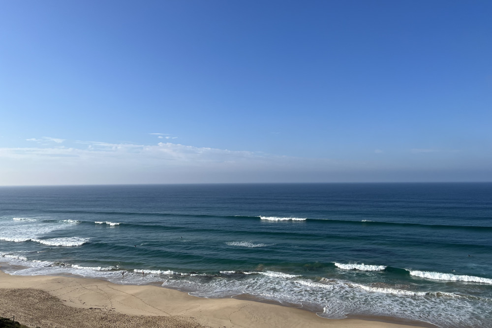
Inconsistent but surfable this AM
This week and weekend (Jan 27 – 30)
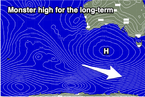
The small, inconsistent W/SW swell and S/SE windswell seen today will ease into tomorrow and a broad, multi-centred trough that's brought the humid weather all week will start to move east, squeezing pressure gradients with a high in the Tasman Sea.
Strengthening N/NE winds will then be seen into tomorrow morning, easing a touch into the afternoon but with no size. Both locations only look to be 1-1.5ft, hardly breaking on the early morning high tide.
Friday morning will remain tiny in size and conditions should be clean again with a light N'ly ahead of a shallow S/SW change as the trough pushes further east.
A high pushing in behind the trough will bring moderate to fresh S'ly winds on Saturday but with no new swell, while we'll see our new, inconsistent W/SW groundswell filling in on Sunday as winds shift E/SE in the morning (moderate in strength) ahead of gusty afternoon S/SE winds.
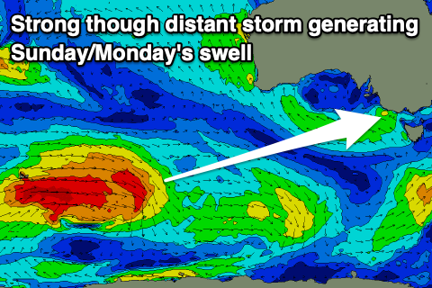 The polar low linked to this swell has formed around the Heard Island region and is generating a heathy fetch of gale to severe-gale W'ly winds through our swell window while tracking east. It'll break down south of Western Australia tomorrow evening, leaving the swell to travel up and towards us for Sunday.
It'll be inconsistent but we should see the Surf Coast building to 3ft to occasionally 4ft into the afternoon on the magnets and 5-6ft to the east. Those winds will create average conditions though, with Monday looking the pick as winds shift around to the E/NE-NE ahead of sea breezes.
The swell should still be fun in size, easing from an inconsistent 3ft on the Surf Coast magnets and 4-5ft to the east.
Longer term a much weaker polar storm looks to generate a smaller, mid-period SW swell for Tuesday as another trough moves through bringing a N/NW offshore ahead of a stronger S/SW change. Size wise it looks to 2ft to possibly 3ft on the Surf Coast and 3-5ft to the east.
 Behind this trough another high will slowly move in, maintaining gusty S/SW winds on Wednesday, shifting S'ly Thursday and then SE into Friday but with no new swell.
The outlook into the start of February looks like more of the same with winds out of the east and building levels of south-east windswell as instability to our north and in the Tasman Sea squeezes high pressure sitting to our south. The blocking pattern will also prevent any major swells being generated. More on this Friday.
Comments
God this has been a terrible run, beautiful weather but just tiny low period waves, its like ground hog day, few calls of worst summer ever.
Does look like the banks are getting better though which seems to happen with a run of small days and any east in the wind.
Shocker all right. these 2 week foreys can be uplifting or crushing. . Yet I have to know.
Been great on the western end of the peninsula, best summer I've seen
Ha!
Have a mate surfing on the other side of the Otways, claiming it's been chest to head high and just about perfect beaches. No complaints from him.
Yeah would be down there as gets more swell, Woolamai & Kilcunda have been knee to waist high on sets most of the time and inconsistent weak & crowded.
I loved these conditions as a grommet, but these days just too small & weak.
Your mate is lieing to you banks have been terrible everywhere
Pretty flat on the open beaches all week and barley got into the mid 30s within the city. Humidities been nice though
Head high rattlers and no one surfing from Portsea to the mountain range for weeks
Head high? The clubbies would have to close the beach!
your taller than me bone
Been a great run of weather, we really get it all down here in Vicco....icy cold winters, hot summers. Sometimes dry sometimes humid.
The bay is super warm, had some great deep water (well, for the bay) swims. Got to be mid to low 20s.
But yeah, surfwise, worst run I can remember in the last 10 years or so I've lived here.
Week leading into Xmas was really fun, 4-5 days of good surf for this time of year. That was 6 weeks ago. Since then, there was 1 good day, which was 2 weeks ago. Been a lean run that’s for sure.
On the flip side, best summer weather-wise I can remember for a long time. Lots of beach time with the fam
Bit of fun on the ninch today. The water was spectacular!
Plenty of waves but really small. There have been the odd slightly bigger days but it gas been pretty gutless, case in point today. The small wave boards gave all been getting a workout.
I'm not sure that down south/ west of the Cape actually gets any more swell than the open beaches on the MP and the island, same orientation.
Answer to that last question.. bathymetry ;)
Hahah there you go, he beat me to it.
It definitely does blackers. Yeah it faces the same direction but ………. etc will 99% of the time be 2-3 feet bigger than Gunna - Portsea.
I’m guessing it’s deeper water closer to the coast so the swell doesn’t lose as much strength but Craig could probably correct me hahah
Apparently, it is 24.7777% bigger and 32.6666% scarier.
Yep loss of energy due to bottom friction through Bass Strait shaves off a couple of feet.
Wellthereyougo. Cheers.
How are the storms down your way guys and gals? The cameras look insane with it lighting up every second or so.
Woke up with the bedroom bedroom being lit up. Pretty cool
Yeah, no rain though. Be pumping chest highties today. Without the big wave chest beaters.
Yeah very localised, would be torrential under one of the cells though.
seems to be just skirting past Sorrgowrie, a good light show though.
It's interesting these major storms pretty much always go right through Melb & the burbs but miss or just the edge hits coastal areas, very tropical weather though very humid.
Yeah, or like last night heading straight for the peninsula out of the NW then vanish as they hit the bay.
All topography based.
Storms fired up west of and across the small ranges to the west and north-west, helped by orographic lift.
On the down-slope side the air is descending and warming (drying out), taking away the energy source hence them petering out.
I think the storms coming from the NW get split but the Macedon ranges
If you're on the right board there's been fun waves about. Hot in a springy yesterday arvo and surfed just with friends in glassy 2ft peaks with 500 on the beach. Doesn't get much more pleasant in the water in Vic. But a groundswell would be nice.
Yeh I'd be keen to see historic stats on water temps... this summer feels like water temps have been at their highest for some time. Not sure if imagining it or not
Been bodysurfing 2-3 times a week due to the lack of decent surf. Water does feel a touch warmer this year which is a little surprising considering how cool spring. Also felt like a late start to summer this year. loving the warmth though.
Looks a nice 21-22 on the Surf Coast..
2°C above average..
So good wish it was always like this
Wow thats weird how the estuary system of Corner inlet (behind Wilson prom) and Lakes Entrance are so cool even though they are very shallow much shallower than most of Westerport bay that has the deepest shipping channel in the southern hemisphere.
I havent been fishing but the Tuna have been going off too even a few odd ones caught in the bay and the quality in size of King George whiting have been some of the best I've ever seen, in the past its been rare as hens teeth to get a 1KG plus whiting maybe one a year is caught, but this year ive seen a few reports/photos of 1kg plus fish.
Indo, looks like a data issue there.
Checked a day before and it is warm as..
Always great to double check data if you can, glad I did.
Ok cheers thats makes sense
Any correlation with water temps and shark sightings?
It's probably my perception but the vic emergency app has pinged a lot more this year than previous ones.
I know it's multi-factorial and maybe more people in the ocean because of the hot weather and more people notifying via the app etc.
But curious nonetheless.
Sure they aren't Gary G sightings?
Whilst Gary loves exposing himself to the exposed coastlines, unless the app you're referring to is OnlyFans you won't have sighted Gary on it.
Gary was recently sighted west of the Otways but didn't sight many other surfers while there. One day it was smaller than Gary has ever seen, 1ft waves crumbling over the sand at a spot that is never that small.
I've noticed it too, pinging like crazy and usually in the same locations
Yeah I wondered if it was the same creature cruising the same spot.
Don't dorsal now have the shark number so you know?
Ooh didn't know that :)
Will check it out.
A few of the blokes who have been chasing the tuna just outside the heads have said there have been quite a few big fish swimming around. I'm not sure how the app works but could it be the fisho's reporting them?
Today
https://www.dorsalwatch.com/report/index.html?country=1
(Link doesn't take you directly to surf coast - have to set location to search)
COMMENT
1X BRONZE WHALER AND 1X HAMMERHEAD SHARK SIGHTED BY LSV IN FAIRHAVEN AREA LOCATION: FAIRHAVEN, MOGGS CREEK SIGHTING CONFIRMED: AIR - LS30 SPECIES: BRONZE WHALER 2.5M, HAMMERHEAD 2.5M BEHAVIOUR: BRONZE WHALER IS 600M WEST OF CLUB HANGING AROUND IN SHALLOWS, HAMMERHEAD IS 150M OUT OF MOGGS CREEK RIVER MOUTH NUMBER OF SHARKS: 2 Provided by the Victorian Fisheries Authority.
https://www.bay939.com.au/news/local-news/131519-beach-evacuated-at-fair...
Ouch - was swimming very close to there with the kids last week.
Same. Was out there 2 days ago with a large seal swimming around. Nothing really to fear though. Hammerheads and Bronzey's not much of a threat.
KROCK has the inside scoop on this:
https://www.krock.com.au/news/local-news/126743-shark-sightings-high?fbc...
One thing I've noticed down our way is the super low tides recently. I've looked for data, but only have only found this year and last to compare - on BOM and only data for Port Phillip Heads. Am I right? Has anyone else noticed this?
Had a very quick look to 2016 and the tides look about the same.
There's likely be an inverse barometer effect occurring with the constant high pressure, pushing down sea levels a touch more than normal. https://www.swellnet.com/news/swellnet-analysis/2022/01/27/midsummer-recap
Having a search for the sea level residuals now.
Awesome. Thanks Craig. Is there a possibility it's localised also.....from about Anglesea to Lorne ?
That can happen if there's a coastally trapped wave but these things are usually forced by wind (ie gale-force westerlies and cold fronts through the Bight).
Great historical updates today Craig, appreciate it.
No worries Dx3, love it!
Sky has gone black here, its on its way.
BTW got caught in one of those torrential downpours while walking the dogs this morning, felt like I was in FNQ.
Yeah radar looks ominous!
Bit of action this arvo
Radar lighting up now!
Light show going off!
Epic lightshow in the city....crazy watching the planes line up and fly straight into it.
Anddddd loudest crack of lightning on peninsula ever surely approx 9:23
Felt like the biggest lightening storm I’ve ever experienced tonight on the surf coast. House was shaking.
Great reading. How could anyone ever cancel their subscription to Swellnet. The constant informative and thoroughly interesting information is gold to all of us. It seems almost anytime I get on here there’s some data or meteorological fact that just makes sense and REALLY well explained.
Kudos to all the folk that comprise that team. Alas, most of us subscribers reckon we know a bit more than your average Jo/Joanne on the street and its great that a topic that affects all of us is robustly discussed whether we are right or wrong.
Thanks for the very kind words Alfred, very much appreciated and I love teaching and helping people learn/understand the infinite processes that occur constantly surround us.
Some serious rain and thunderstorms coming through this arvo.
And Sunday 15.6s @ 3-4ft is much better, i can live with ESE @ 15knts
Alfred. I’ll give Craig till the end of feb (no longer) to produce some better foreys or I’m pulling the credit card.
Greyhound. Totally agree. A lot of us may have a copy of this, I’ve just finished reading mine, which is the 3rd and current Edition, ‘Waves and Beaches’ ‘The Powerful Dynamics Of Sea and Coast’ by Willard Bascom & Kim McCoy. A very fine publication, first written in 1963 (Bascom) and updated in 1979 (Bascom). What a book, every surfer should read it. If anybody has the addresses of the engineers or geomorphologists who consulted on the Collaroy sea wall, I’d be more than happy to send them a copy. Simply can’t believe the mistakes and ignorance to all the basic principles of the sea. I’m pretty sure that most or all of the Swellnet team would have a copy.