Midsummer Recap

We're just past the halfway mark of summer but I feel it apt to provide an intra-seasonal update, or confirmation for those suffering in the southern states that the run is as bad as they think, and to reaffirm that the East Coast has been the place to be.
By the end of this double-dip Niña episode most will be well versed in how such a Pacific Ocean setup effects the swell/surf around the Australian continent. Let's not concern ourselves with the possibility of a triple threat Niña next summer, that's for another day.
I've brought up the Mean Sea Level Pressure (MSLP) and surface wind anomaly charts from the start of December through until now. These charts show the difference in surface pressure in wind from the long term climate average from the years 1981-2010. For those who need a refresher, circulation in and around high pressure is anti-clockwise, while lows see winds blowing clockwise.
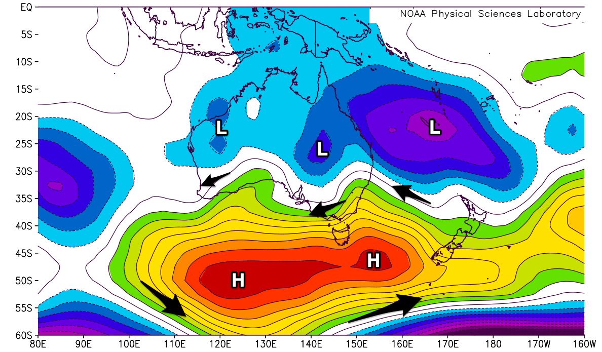
Mean Sea Level Pressure (MSLP) anomaly for the period 1st Dec to 24th Jan
What's immediately obvious is the large high pressure anomaly stretching out across the south of the country, extending well south towards polar latitudes.
It's worth remembering that during summer, the sub-tropical high pressure belt shifts further south across the Southern Ocean regardless of being in a La Niña, neutral or El Niño year. This pushes the westerly storm track further south, resulting in smaller, less frequent groundswells.
La Niña years exacerbate this, with the highs shifting even further south, cutting off the supply of swell further. The chart shows this clearly, with the pressure being higher than the long term average for the the December/January period.
The Southern Annular Mode (SAM) which is measure of how far north or south the westerly storm track is from normal also shows the impacts of La Niña. When the index is positive the westerlies are restricted to the pole and further south, as is evident since mid-October in the image below. When negative we see the storm track lifting north close towards Australia.
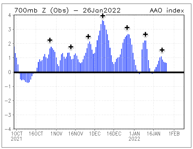
Southern Annular Mode (SAM/AAO) index since early Oct 2021
Coming back to the MSLP anomaly chart, another feature that stands out is the lower than normal pressure across the Coral Sea. This is linked to the warmer than normal sea surface temperatures in the western Pacific Ocean, brought by stronger than normal easterly trade-winds under a La Niña setup.
With low pressure squeezing high pressure to the south, we see a favourable swell generating setup for the East Coast and it's hardly been below 2ft since the start of summer (mostly much bigger). The warmer than normal sea surface temperatures and instability have also produced a couple of tropical cyclones and larger swell pulses. The first for the start of the year being Tropical Cyclone Seth which tracked close to the south-east Queensland and northern NSW coasts, with Tropical Cyclone Cody sitting further afield between Fiji and New Zealand.
An inland low pressure trough can also be seen across central Queensland, putting a pinch on the northern flank of the high pressure anomaly sitting under Victoria, bringing though generally favourable easterly winds (for the beaches) but alas with no swell to capitalise on.
The setup responsible for Western Australia's excessive heat is also visible with an inland heat trough bringing persistent easterly winds which have drawn in heat from central Australia. Swells have been sporadic and not overly sizey leading to a tiny run of surf for the metro regions, with small workable waves in the Margaret River region.
Finally the wind speed and direction anomalies for the past two months shows a stronger than normal east to south-east wind pattern through the Tasman and southern Coral Seas, and those easterly winds across Victoria, Tasmania and South Australia.
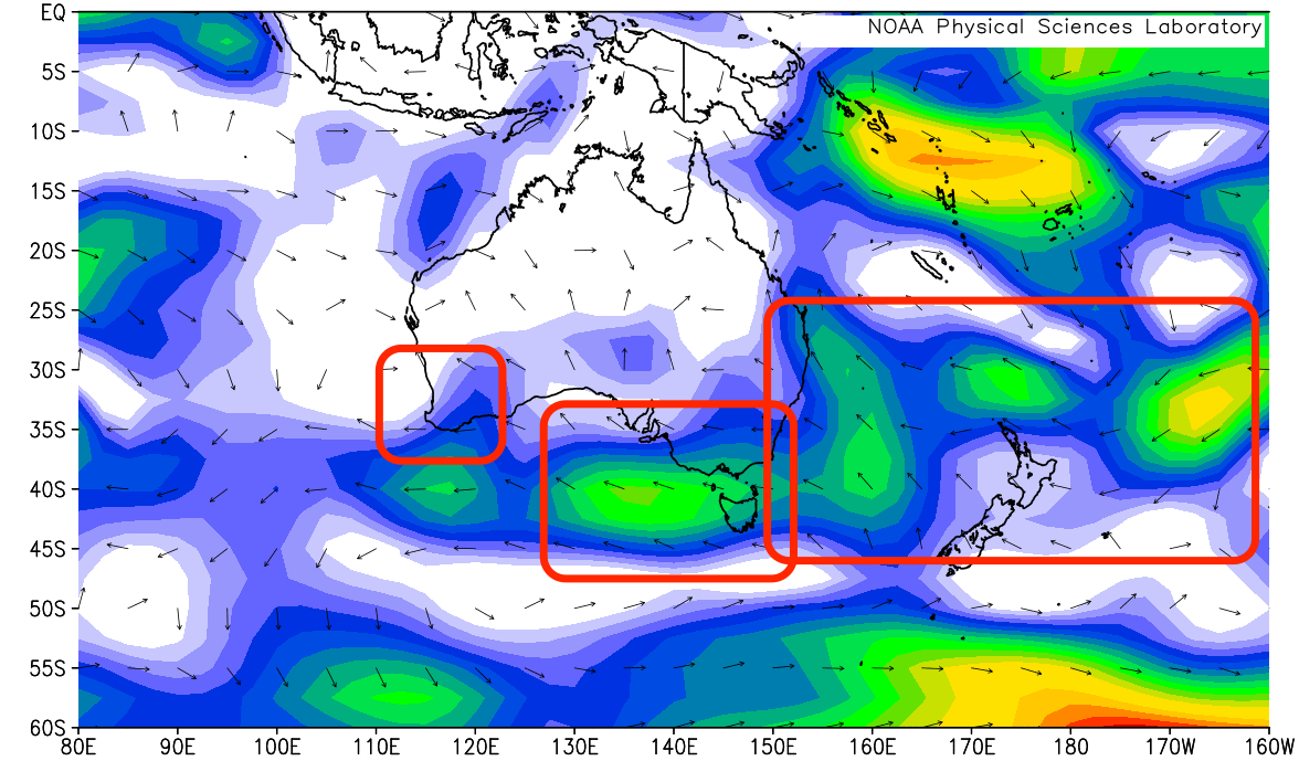
Wind speed/direction anomaly for the period 1st Dec to 24th Jan
Looking at the month ahead (February) and unfortunately it looks like more of the same in regards to a relentless blocking pattern for the southern states, though slowly weakening into the second half of the month, with no let up in the swell generating systems for the East Coast.
We'll provide an outlook for the coming autumn/winter in the coming months.
Comments
Thanks for this article Craig. I was just wondering about this.
I can't immediately remember a better start to a year in SE Qld.
It also feels like we've got a bit of cooler March weather already. And our northerly trades were pretty well skipped in spring and early summer this time.
Seems like quite a different pattern the past 6 months or so compared to the norm.
I don't think so GSCO.
It's a classic La Nina pattern.
Around here (NENSW) a mild, wet summer is actually the climatological mean.
Probably stands out due to the severity of some of the El Nino/ AAO patterns we have had in recent summers.
Cool, I get what you're saying. Recently over the years I'd drifted into largely writing off Oct-Jan and going overseas, coming home sometime Feb.
Craig, how has this set-up affected rainfall in Australia?
Only thing worse than the mossies this summer are the leeches in the bush.
Yeah, it's been wet.
Leeches have been HECTIC!
Craig….Are you hinting at La Niña for next summer too?
Please please please .
Looks like a possibly weak event tending that way. Might not quite reach the thresholds but a similar setup. Wait and watch.
Here you go Spuds.
December and January to date anomalies and totals.
Most locations have received lots apart from northern, inland and coastal Qld (Jan especially under) and parts of WA. The Madden Julian Oscillation or lack there of across northern Australia is the reason for lack of rainfall through January.
December..
January..
Man it's been dry in SW WA. Basically no rain for two months.
Raglan had 38 days with zero rain. And lots of easterlies :-)
What's the fire situation like over there?
I was up in Raglan last week and although the grass is starting to brown off, the forest is still pretty lush. Winter rainfall is exceptionally reliable in NZ so we don't get those multi year droughts that happen in Australia. Fires do happen in NZ but are usually fairly small in comparison and are relatively easily contained. Earthquakes and volcanoes, now that's another story!
This is my 20th year in Vic and pretty sure it's the worst summer I've seen.
You lot on the east coast better enjoy it, and you've lost all entitlements to whinge about surf quality til about 2025.
Not complaining in Tassie, we get waves from west through to NE as long as you don't mind doing some driving. Great summer for our East Coast!!
Yeah the East Coast has been great eh!
absolutely - the worst summer surf in vicco since..... i can remember - i'm in my 47th year here
Still weather has been superb down south, one sunny day after another 30º plus dry and hot water temp dreamy for down here all that's missing is swell. Two out of three aint bad anyone for a snorkel?
Fast Forward to late March, Please!. The lack of Surf along the M.P. and W.P. areas this summer has been p*ss poor. The hot humid weather makes doing anything recreational that is physical and outdoors to be more of a challenge too.
And with the second last sentence my arms jumped off and ran away , and my back and shoulders fell off !!
Just out of interest, what's it been like at Johanna? I thought that joint pretty much never goes flat.
Surfed it a couple times, including today. Barely 2 foot. Strange summer indeed…
Holy guacamole, things are worse than I realised. A moment of silence for our Victorian brothers and sisters in their hour of need.
If we’re in a similar La Niña pattern as last year will WA be getting smashed by an endless barrage of mid latitude fronts again like last winter?
There were a few good days but well under par imo.
I’m really hoping captain covid opens up to international travel by July / August
Hopefully not, but we'll see.
Craig does global warming mean this summer pattern will be more likely in future years?
This hasn't been studied enough to give a confident answer unfortunately. It looks like there'll be various shifts, strengthening/weakening of the subtropical high pressure belt in response to a warming depending on regions.
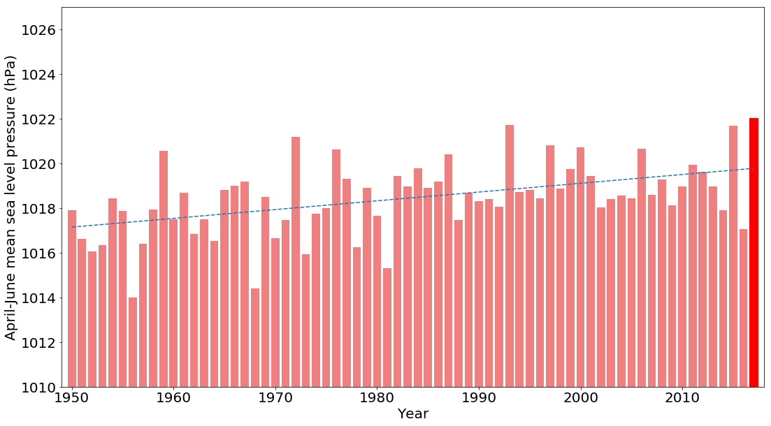
In saying this for Australia studies show that the subtropical high will stay further south due to the expanding Hadley circulation (expanding tropical zones), keeping the westerly storm track at arms length to the continent. We've seen this over the past few decades with a strengthening of the subtropical ridge and more frequent positive Southern Annular Mode events and less cold fronts impacting the south-east of the country. Whether this has been from a warming planet or other inter-decadal oscillations is still being researched.
Here's the MSLP (April to June) trend for southern Australia over the last 70 years..
Thats really interesting.
Thankyou for making me completely depressed.
- A Victorian surfer
Thanks Craig, great stuff again.
Despite all the increased activity it still feels like there have been fewer cyclones. Not sure if that's my imagination or it's still a bit early to tell before we get through Feb and March.
Huge lightning bolt just came close to the lineup at Pier 3182, huge explosion and car alarms set off! Nice little reminder of exactly who's in charge here!
Normally a run of small swells and east winds is great for our beaches even if small you get pulses, but this run over January has been just too small and very weak, just that size where its just dribble and only some banks get the swell.
Looking forward to Sunday though 3-4ft @15.6s and wind not too bad.
Time to take up windsurfing in the Summer on the Surf Coast in Victoria?
Thanks Craig for the in depth analysis but still trying to give us a compact answer is work much appreciated. I've read it a few times. It's about the westerly storm track and the southerly position of the high, that latest chart shows the highs are higher also. Not liking the trajectory and that's what I wanted to understand better so thanks for that. Hmm Tassie?
Yep, you nailed it!