Autumn 2025 Retrospective

As the skies finally clear across the East Coast and rain-bearing fronts start to impact the southern states, we herald the start of winter and take pause to look back at one of the most dynamic autumns for weather and swell in many years.
Firstly looking at the East Coast and if it wasn’t pissing down rain and onshore, it was otherwise pumping.
Though it was only a period of three months, the number of varying, XL swell events that impacted the east was quite incredible.
Coming off a summer La Niña signal in the Pacific Ocean, the atmosphere and oceans were primed with heat and moisture coming into autumn. Northern NSW and the Mid North Coast copped the brunt of the rainfall when conditions became favourable.
Following a dry February, Severe Tropical Cyclone Alfred broke the pattern in early March, with its uniqueness underpinned by the way it meandered down through the Coral Sea caused by a lack of upper atmospheric steering winds. This created havoc for forecasters even with the most sophisticated atmospheric modelling. All options were on the table, from a devastating coastal crossing to drifting south-east while undertaking an extra-tropical transition.
In the end, Alfred did what it wanted and sat due east of Brisbane, moving ever-so-slowly westward while slowly weakening. It was the best case scenario both for averting major structural damage across south-east Queensland and for waves. Rather than a single day of large, epic surf, Kirra pumped for many days, breaking through the first weekend of March before climaxing on Tuesday 4th and Wednesday 5th.

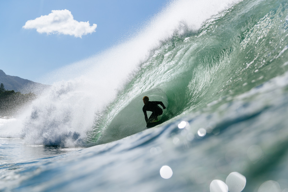
Harry O'Brien on top of his speed management (Bystrom)
The following days, however, were a washout and they contributed to a huge loss of sand at Snapper Rocks and the Super Bank, with all the sand from Leticia Spit around to Duranbah scalped down to the coffee rock, then dumped far offshore inside the bay at Snapper. It's still there now.
In northern NSW, TC Alfred created a lot more losers than winners in the sand department and the situation never really resolved itself with otherwise perfect incoming swells breaking over parlous bottom topography. Like the Superbank, many of northern NSW's premier waves still haven't recovered - they're in sand deficit and struggling to break.
On the other hand, from the Mid North Coast southward, setups shifted but generally held up, with novelty breaks awakening through the peak of the Alfred swell, followed by great surf as the more open stretches came into play.
For southern NSW, the end of March brought with it a swell to remember, with a storm-force Tasman Low feeding off sea surface temperatures that were 26°C due east of Jervis Bay. Satellite observations picked up a broad, significant fetch of 55kt+ winds aimed squarely at southern NSW, with the low itself sitting far enough offshore to bring favorable westerly winds once the swell arrived on the coast.
Across Sydney, some of the largest, rideable waves ever seen went down off Ben Buckler (hats off to Chase Hardaker pictured below), while numerous ‘big wave’ locations further down the coast became bay-wide closeouts, struggling to handle the long-period 15ft swell.

Ben Buckler as big as it gets (Orlanda Golfin)
Puzzlingly, while the low sat far enough offshore to, at least theoretically, expose northern NSW to large surf, the swell never really made landfall. It got lost somewhere around the Coffs Harbour area, so while the biggest swell in recent memory hit southern NSW, the waves barely reached 4 foot at northern NSW's marquee breaks.
Alas, southern NSW continued to pump on the backside of the swell's peak, with the low only slowly weakening while drifting away to the east, resulting in a long, gloriously wagging tail of swell into the start of April.
Two extra-large swells down, one more to come and that was from the very impressive, extratropical transition of Cyclone Tam.
Tam was a much shorter-lived cyclone compared to Alfred, with it forming south of Fiji before quickly drifting further south towards New Zealand while interacting with another broad area of warm sea surface temperatures.
When cyclones undertake an extratropical transition they grow in both size and strength. Ex-TC Tam did this due west of New Zealand’s North Island, right in the East Coast’s prime easterly swell window.
A strengthening fetch of severe-gale to storm-force easterly winds projected west towards the Australian mainland, producing yet another extra-large groundswell event. This time the direction was dead east and it peaked on the morning of Good Friday.
With most people celebrating the Easter Long Weekend, the holiday crowds awoke to see pristine 10-12 foot lines of groundswell under sunny skies and offshore winds. It was an awe-inspiring sight. Along the length of the NSW coast, headlands were full and every set or wipeout was cheered right until dark.
Like the other swells, it provided a long tail of pumping surf that gradually tapered through the rest of the weekend. Though for most, Friday will be the day to remember.

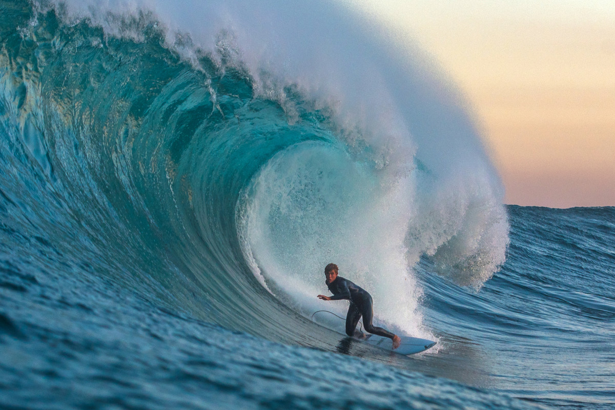
Tom Myers on a wave of a lifetime and one of the best ridden in Sydney (Archer Drinan)

Woody Bouma cruising on a hefty bit of water (Brokensha)
Then came May and the stubborn, troughy pattern that brought record flooding to the Mid North Coast as it sat near stationary right through the middle of the month.
Just as the floodwaters started to improve following Alfred's deluge, the lineups were again muddied with runoff. However, for those fortunate enough to miss out on major inundation, the last weekend of May provided a pay off. As the trough peeled away from the coast and winds veered offshore, they revealed a beautifully angled east-northeast swell.
From Coffs Harbour through to Eden - even north-east Tasmania - you couldn’t go wrong, and this brought to an end one very dynamic autumn of waves.
East meets west with Sol Gruendling in the middle (Hughes)
Below is the mean sea level pressure anomaly chart (left) - which is the difference from the long-term climate average - for the three months of autumn. It paints a clear picture with a low pressure anomaly sitting off the south-eastern Queensland coast, cradled by high pressure in the southern Tasman Sea. This provided the constant source of easterly energy and moisture for the East Coast.

A marine heatwave event off the North West also brought lower than normal pressure, while an inland depression across the centre of the country was linked to the moisture-laden air tracking in from warmer waters to our north.
I’ve also included the precipitable water anomalies (right) - the amount of water available for rainfall - with the north-east of the country seeing much higher levels than normal for autumn.
In stark contrast to the sodden East Coast was the extended drought conditions across South Australia, parts of western Victoria, and south-west Western Australia.
A record dry start to the year led to an ecological disaster across Southern Australia as a harmful algal bloom spawned in Backstairs Passage and spread its way, first towards Victor Harbor and the Murray Mouth, and then further up into the gulfs and Kangaroo Island.
With the lack of any true frontal progression to mix up the gulfs and breakdown the algae, it continued to spread, impacting more and more marine life.
While devastating on one hand, the placid local winds provided endless days of great waves and conditions for both the Mid and South Coasts, with west swells aplenty originating from near Western Australia.
Victoria was also a beneficiary of the generally light wind pattern with plenty of moderate-sized swells mixed in with the odd large event. The most memorable being the swell which arrived just ahead of the Rip Curl Pro.
Stacked Victorian lines (Romy Becker-Roache)
For southern Tasmania, the theme of favourable conditions and consistent swells continued, with a couple of standout days across the big wave spots.
Over in the west, and the stellar run of swell and offshore winds seen through summer held up well into autumn with the Margaret River region seeing plenty of large surf with favourable conditions as the swell-generating storms stayed mostly at arms-length away from the coast.
Big south-west blows were rare and short-lived with the mobile nature of each system allowing conditions to clean up for the peak, if not the still-large backside of each swell.
Okie Fraser poised at The Box (Jovic)
Looking at the mean sea level pressure anomaly chart above, and the higher than normal pressure sitting south-west of Western Australia allowed winds to blow more offshore than usual in autumn, while lower than normal pressure across 60°S spawned numerous swell-generating systems for the southern states.
All in all, the country scored well above par this last autumn, with action aplenty from west to east, north to south.
Comments
How good hey! definitely the best Autumn in recent years.. the aching body reflects it!
Winter off to a bang too yewww
Great wrap Craig.
Worst one ever here- we were right in the cross hairs of onshores, rain and with no banks there were no great days.
Thanks Craig.
One of the worst ones on the SC too, couple days from Alfred about the sum of it.
A season book-ended by Alfred and last weekend's pumping NE swell. I'm not sure how far back I'd take it, but it was at least the best autumn of the '20s.
Amazingly, it wasn't till the very end of the season that we had the first due south swell. Alfred came in E/NE, the big swell on 1st April was E/SE, Good Friday swell was dead east. Other mid-range swells clocked in similarly, with lots of E in the mix.
Two broken boards, five broken leggies, and a niggling forearm injury is my tally.
Great write up. Some memorable, clean swells for sure. On good friday every spot in these parts, and some spots that aren't even spots, going off...all day.
But it seemed like all the goodness of Autumn was concentrated into a few days.
Is cyclone like swell south of the NSW North Coast a sign of things to come?
Potentially yes.
Pretty good Autumn in Vicco. My time is split between MP and SC and surfed wayyy more on the MP though
Appreciate the lack of attention on Vic. Glad you all “scored.”
Rain rain & more rain with major flooding & howling onshores for days on end here on the Mid Nth Coast. Total devestation for local farming communities & regional towns (Taree, Wingham, Kempsey, Frederickton, Upper Hunter, etc). Yes when it did finally go offshore there were waves but if you lived near an esturary or rivermouth you just had to watch the swell go to waste! All in all a few pumping days here & there but the best swell event was undoubtedly the system that stayed offshore & produced the GOOD Friday huge perfection. Unfortunately I was on the Surfcoast @ the time of this whole event looking at the best low I've seen in the Tasman for years which didn't get into the Surfcoast. However 13th Beach had fun waves for several days & water temp was an amazing 21deg's! Climate change in action is for surfers a real Ying/Yang situation.
The run of big swells (east coast ) was next level great viewing..
How's that photo of Tom Myers. Great shot.
Poor ol' mate on the inside about to get flogged.
No waves for virtually 6 months then April bang swell narvada with small,medium and giant perfect swells mixed in with rideable messy swells its been so consistent for the east coast fantastic.
Tom Myers… those guys around that area of Sydney are killing it. Between that wave and the Bower is seeing the best surfing on the east coast these days. Well done!
Thanks for the wrap up Craig. A phenomenal amount of energy hitting the coast. Some amazing scenes that are surely unlikely to be trumped for years to come. Time will tell.
The carnage continues up here with the big south swells. As the dunes retreat, the big ol' pandanus and casuarina falling will hopefully provide some foundation for the sand to put some slope back on the beaches.
BTW, the article seems to be "unlocked" with the tabs up the top.
Which user is this, we've had a glitch.
Apart from a well-timed Vicco strike the week before Bells kicked off, that was my worst Autumn for years. Brown, onshore, too big, no banks with very little in-between. Hope winter is better
And of course South Oz - very poor Autumn wave wise and more importantly the worst marine disaster on record with the massive algal bloom, huge marine die off and I for one got sick from it a number of times - nothing to celebrate here.