Good fun Tuesday, average for the rest of the week

Victoria Forecast by Craig Brokensha (issued Monday 19th October)
Best Days: Tuesday, possibly Friday morning, Saturday and Sunday east of Melbourne
Recap
Light winds and clean conditions across the Surf Coast early Saturday morning with a small 1-2ft of swell, while the Mornington Peninsula was bumpy with a moderate onshore breeze up at dawn.
Sunday saw two separate pulses of strong W/SW groundswell, the largest into the afternoon with 8ft+ sets reported across exposed breaks on the Mornington Peninsula and 3-5ft waves on the Surf Coast. S/SE winds however limited the best waves to only a select few spots.
Today the swell was easing from the 3ft range on the Surf Coast and 6ft on the Mornington Peninsula with better NE winds across most locations. We'll see the surf drop further during the day as SE sea breezes kick in.
This week (Oct 20 – 23)
Make the most of tomorrow, as besides Friday morning when we may see variable breezes, onshore winds will create poor conditions.
Tomorrow will be best east of Melbourne and across other swell magnets with an easing swell from 2ft on the Surf Coast and 3-5ft on the Mornington Peninsula under local offshore winds, becoming variable into the afternoon.
 Into Wednesday the surf will start tiny, but a strong onshore change will move through around dawn, swinging strong SW and then S/SW into the afternoon.
As discussed on Friday, with this change we'll see a solid increase in windswell, building to a stormy 3ft on the Surf Coast into the afternoon and 6ft on the Mornington Peninsula.
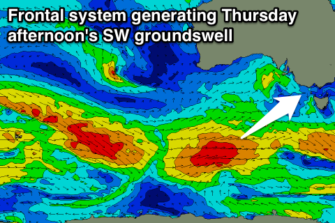
This windswell is then expected to subside into Thursday morning, ahead of some new SW groundswell from the earlier stages of the polar frontal system linked to Wednesday's change.
Currently the early stages of the polar front is seeing a broad fetch of W/SW gales in our south-western swell window, with it due to project north-east towards us through tomorrow.
A moderate sized SW groundswell should be generated by this front, building Thursday afternoon and peaking later in the day/overnight.
We should see the Surf Coast kick to 3-4ft with 6ft to sometimes 8ft sets on the Mornington Peninsula later in the day, easing from a similar size Friday morning.
Winds however will remain poor and from the S'th Thursday, with Friday seeing lingering S'ly breezes that 'may' tend variable during the morning. We'll have more confidence on this occurring in Wednesday's update.
This weekend onwards (Oct 24 onwards)
Into the weekend we'll see the swell slowly tail away as winds improve for the Mornington Peninsula. Light E/NE breezes are due Saturday morning, with better N/NE winds Sunday with easing 5-6ft surf Saturday, becoming more manageable and in the 3-5ft range Sunday morning.
Longer term we're due to see a moderate sized S/SW groundswell for Tuesday next week, but winds look to be a problem and onshore from the S/SE in the wake of a change Monday. We'll have a closer look at this Wednesday though.
Comments
How big will the waves be on the surfcoast on the weekend
Will it be better Saturday or Sunday on the surfcoast
Around an inconsistent 2-3ft Saturday but not the best conditions, cleaner Sunday but easing from 2ft or so.