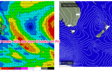
E’ly gales in a broad fetch remain into the new week with a massive high new New Zealand (1042hPa) acting as supporting cradle for the Tasman low which will be drifting eastwards to a slot north of the North Island.
Primary tabs
/reports/forecaster-notes/sydney-hunter-illawarra/2025/07/30/extended-large-ely-swell-event-intense
freeride76
Wednesday, 30 July 2025
/reports/forecaster-notes/sydney-hunter-illawarra/2025/07/28/unstable-week-ahead-dynamic-weekend
freeride76
Monday, 28 July 2025
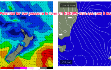
Over the weekend there’s now growing agreement on a coastal low (possibly some variant of an ECL) to form off the NENSW or SEQLD coast and intensify as it moves into the Tasman, with potential for severe weather and sizey swells.
/reports/forecaster-notes/sydney-hunter-illawarra/2025/07/25/ne-windswell-short-term-uncertain
freeride76
Friday, 25 July 2025
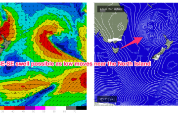
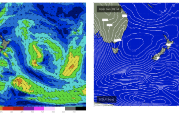
Low pressure formation looks likely, possibly a strong cut-off low moving into the Tasman Thurs and offering an initial spike in S swell Thurs before better angled S/SE swell into the weekend if the low hangs around in the south-east Tasman near the South Island.
/reports/forecaster-notes/sydney-hunter-illawarra/2025/07/23/ne-windswell-ahead-then-s-swells-medium
freeride76
Wednesday, 23 July 2025
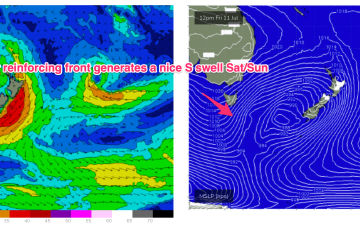
EC has a much more bullish outlook with a robust cut-off low sitting in the Tasman for the second half of next week.
/reports/forecaster-notes/sydney-hunter-illawarra/2025/07/21/downgraded-e-swell-still-offers-some-fun
freeride76
Monday, 21 July 2025
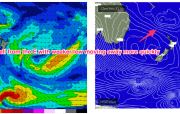
Unfortunately, compared to Fridays expectations the interplay between these two systems is weaker, with a more constrained fetch of lower windspeeds that drifts away quicker than modelled on Friday. That will result in smaller east quadrant swell this week, relative to Fridays expectations.
/reports/forecaster-notes/sydney-hunter-illawarra/2025/07/18/nice-run-ely-quadrant-swells-expected
freeride76
Friday, 18 July 2025
There’s still some model divergence later next week but for now we’ve got reasonable confidence a broad fetch will develop through the Northern Tasman as high pressure moves into the Tasman and supplies an anchor for the low.
/reports/forecaster-notes/sydney-hunter-illawarra/2025/07/16/flukey-swell-sources-the-s-short-term
freeride76
Wednesday, 16 July 2025
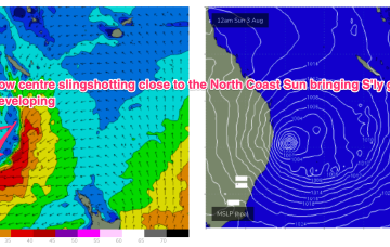
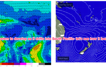
Not much short term gain from this system but there is broad model agreement we’ll see this low deepen and develop into a more powerful system mid/late next week as it drifts into a position north of the North Island.
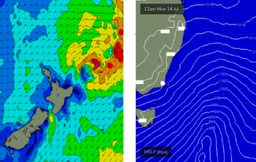
/reports/forecaster-notes/sydney-hunter-illawarra/2025/07/14/more-southerly-energy-inbound
thermalben
Monday, 14 July 2025
A strong front pushed into off the NSW coast the Tasman Sea overnight, and it’s generating a strong flush of south swell that’ll fill in this evening and provide a nice boost in surf size across Southern NSW.
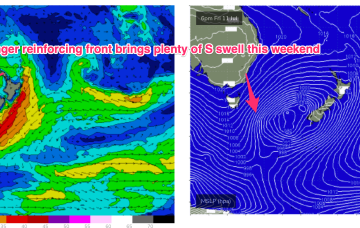
/reports/forecaster-notes/sydney-hunter-illawarra/2025/07/10/lovely-s-swell-weekend-typical-winter
freeride76
Friday, 11 July 2025
We’ll see some nice strong S pulses over the weekend as multiple fetches operate on an active sea state. Nothing huge but of winter calibre.
/reports/forecaster-notes/sydney-hunter-illawarra/2025/07/08/upgraded-s-swell-outlook-the-weekend
freeride76
Wednesday, 9 July 2025
Compared to Mondays notes the outlook for S swell is improved, mostly due to a better aligned following front which conjoins the initial front and forms a slower moving low in the southern Tasman.