/reports/forecaster-notes/sydney-hunter-illawarra/2024/03/08/fun-week-ene-trade-swell-some-small-s
freeride76
Friday, 8 March 2024

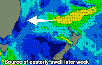
There was a nice, lingering tail to the S swell event but we’re now entrenched in a classic late Summer pattern with strong high pressure moving into the Tasman, setting up a downstream blocking pattern and very healthy tradewind fetch through the Coral Sea, extending E into the South Pacific and south into the Northern Tasman.

/reports/forecaster-notes/sydney-hunter-illawarra/2024/03/05/easing-s-swells-nice-run-ene-swell-ahead
freeride76
Wednesday, 6 March 2024

Classic late Summer pattern next week with high pressure straddling New Zealand, a monsoon trough strung across Northern Australia extending into the South Pacific and a long, broad tradewind fetch between the two broadscale atmospheric features. The fetch is so broad and long that we’ll see quite an energetic E/NE swell propagate down the NSW Coast. 

/reports/forecaster-notes/sydney-hunter-illawarra/2024/03/04/lots-sizey-s-swell-week-easing-thurs
freeride76
Monday, 4 March 2024

We currently have a deep, winter-calibre double-headed low traversing the lower Tasman. Current ASCAT (satellite windspeed) passes show a long fetch of severe gales in the southern swell window and wave buoys are all in an aggressive upwards curve as strong S swells build along the Southern NSW Coastline.

/reports/forecaster-notes/sydney-hunter-illawarra/2024/02/29/winter-calibre-low-brings-days-strong-s
freeride76
Friday, 1 March 2024

Models are holding steady on a winter calibre low tracking well to the south- south-east of Tasmania during Sun and traversing the far Southern Tasman through Mon.

/reports/forecaster-notes/sydney-hunter-illawarra/2024/02/28/sizey-s-swell-the-radar-next-week-strong
freeride76
Wednesday, 28 February 2024

Some quiet days then follow before a much more robust front and low enter the lower Tasman late in the weekend driving some sizey S swell up the coast early next week.

/reports/forecaster-notes/sydney-hunter-illawarra/2024/02/25/quiet-end-summer-robust-s-swell-the
freeride76
Monday, 26 February 2024

We’ve got a weak, troughy pattern in the Tasman Sea, with a minor cold front passing to the SE of Tasmania and a new high pressure cell poised to enter the Tasman in it’s wake. The high cell is weak so we’re looking at a fairly uninspiring end to Summer, with some mid week NE windswell for Southern NSW and small background E swells for the sub-tropics.

/reports/forecaster-notes/sydney-hunter-illawarra/2024/02/22/s-and-e-swells-over-the-weekend-quiet
freeride76
Friday, 23 February 2024

High pressure in the Bight with a trough moving up the coast and robust low (974hPa) moving under Tasmania sets the scene for the weekend.

/reports/forecaster-notes/sydney-hunter-illawarra/2024/02/21/fun-beachies-persist-then-round-the
thermalben
Wednesday, 21 February 2024

The rest of the week looks pretty fun.

/reports/forecaster-notes/sydney-hunter-illawarra/2024/02/19/beachbreaks-teh-win
thermalben
Monday, 19 February 2024

Lots of fun beachbreak surf on tap for this week.

/reports/forecaster-notes/sydney-hunter-illawarra/2024/02/15/plenty-fun-over-the-weekend-more
freeride76
Friday, 16 February 2024

High pressure belt remains strong with cells lined up to enter the Tasman. A monsoonal low in the Gulf of Carpenteria is generating a long cloud band down the east coast. A long, broad E’ly tradewind fetch extends from the Coral Sea into the South Pacific with the tail of the fetch in Tahitian longitudes.