Fading east swells with dicey winds

Sydney Hunter Illawarra Forecast by Ben Matson (issued Fri August 4th)
Features of the Forecast (tl;dr)
- Smaller but still fun E’ly swells over the weekend
- Average weekend conditions but light winds likely early Sat
- Small E/NE swell for Mon with light AM winds
- Low confidence S/SE swell Tues/Wed
- Mod confidence E/NE swell building Wed PM, holding Thurs/Fri with fun waves
- Chance for a sizeable S’ly swell early/mid following week
Recap
Our fantastic, sizeable mid-week E’ly swell eased to 4-5ft on Thursday, and freshening S’ly tending S/SE winds created issues on the surface for much of the day, save a small window of early W/SW breezes at first light across a few locations. Wave heights have eased a touch more into the 4ft range this morning and early light winds are offshore so conditions are clean.
This weekend (Aug 9-10)
Gradually easing E’ly swells will pad out the weekend, initially holding 3ft early Saturday but down to 2-3ft into the afternoon and probably holding somewhere in this size range through Sunday.
A small short range S/SE swell will gradually build through Sunday but it’s unlikely to have much impact on overall surf size across the open beaches. If anything it just may add another dimension of peakiness, which is always welcome.
For the record, model guidance has a minor long period south swell glancing the coast on Saturday but it doesn’t look like it’ll produce anything noteworthy, just a few stray sets at reliable south swell magnets.
Local conditions are looking OK both days; not great but certainly not a write-off. A high pressure ridge to the south will maintain moderate S/SE thru SE winds most of the weekend, though we should see a brief window of light variable winds early Saturday morning north from the Illawarra (this brief AM window is less likely on Sunday, as the ridge is modeled to be a touch firmer).
Coincidentally, locations south of the Illawarra to the Vic border are looking at better conditions on Sunday as the ridge moves a little further to the north, keeping conditions clean through the morning with light winds.
All in all, it’s looking like a bog standard weekend of workable winter beachies.
Next week (Aug 11 onwards)
The start of next week looks a little slow going, with the weekend’s high pressure system in the southern Tasman Sea expected to deflect the storm track away from our swell window.
That being said, a subtropical low well south-east of Fiji yesterday is generating a small pulse of E/NE swell that’s expected to fill in late Sunday and should supply slow 2-3ft sets across open beaches on Monday. A similar wind pattern as per Sunday (light/variable early, tending moderate S/SE during the day) will favour Monday morning for the best waves. Leftover short range S/SE energy should also be in the mix too.
As a side note, there is a low confidence S/SE groundswell from late Monday through Tues/Wed, originating from the polar storm track below New Zealand over the weekend. The models are not confident on a decent solution right now, and it may very well be wiped off the chart over the next few days, but it’s worth noting here just in case.
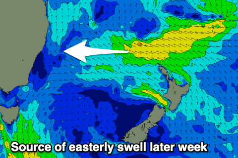
Otherwise, Monday’s swell combo will ease into Tuesday, but Wednesday afternoon should see the arrival of a new round of E/NE swell, generated by an unseasonable trough of low pressure developing off the central Qld coast this weekend, that will slowly track E/SE towards New Zealand’s North Island and deepen ever so slightly.
Although this system won’t evolve into anything major (with regards to fetch strength and alignment towards Southern NSW), it will linger within our swell window for quite a few days and it has enough potential to offer two or three days of wave heights in and around the 3ft range from the E/NE, with a small period punching slightly above this (likely later Thursday).
Current expectations are for light winds too, so conditions should be nice and clean.
Looking further ahead, and the long term outlook suggests we’ll see the Long Wave Trough influencing our region early in the following week, leading to a punchy and possibly sizeable south swell around Tuesday and Wednesday. More on this in Monday’s update.
Have a great weekend!
Comments
Another very thorough report. Thanks.
https://meteologix.com/au/model-charts/euro-ai/new-south-wales/accumulat....
Looking like another very wet week from the 17th to 23rd
Boo