Indonesia/Maldives forecast Aug 7

Indian Ocean Basin analysis by Craig Brokensha (issued Thursday 7th August)
This week through next (Aug 8 - 15)
Our largest S/SW groundswell of the year filled in yesterday with long-period lines wrapping in with size to even the most protected spots.
This saw the Padang Cup run and won by Western Hirst and Jasmine Studer, with the swell now on the ease into today.
We’ve got a large, reinforcing S/SW groundswell on the way for tomorrow though, with it performing well across Western Australia yesterday.
There’s no change to the expected size, with it generated by a secondary, great frontal progression pushing up and under Western Australia earlier this week.
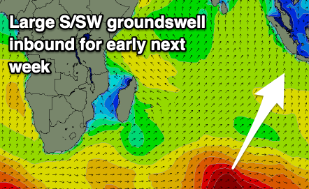
This swell will ease into the weekend ahead of our large S/SW groundswell into early next week.
The strong polar low linked to this swell pushed up and across the Heard Island region yesterday generating a fetch of gale to near severe-gale SW winds, with it breaking down through today.
The swell looks large, but nothing compared to this week’s energy, building Monday and peaking into the late afternoon, easing slowly Tuesday, smaller Wednesday.
The trend will be slowly down all week with no major swell generating systems due to fire up in the Southern Ocean over the coming week. With this, make the most of the current and coming large energy.
E/SE trades are due tomorrow, SE on the weekend before strengthening from the E/SE-SE through next week. Light local land breezes are due each morning.
The coming swells for the Mentawais will come in more south, with tomorrow seeing the strong reinforcing S’ly groundswell, followed by the more consistent energy early next week.
Local winds look generally variable, possibly freshening from the SE at times across southern locations next week.
----------------------------------------------
Maldives:
A good mix of easing S/SE trade-swell and S’ly groundswell are breaking across the region today, with a fresh pulse of SE trade-swell due through tomorrow and Saturday. This was generated but a small tropical depression forming in the trade-flow to the south-west of Sumatra, with this since breaking down.
This will result in easing surf from Saturday afternoon, further into next week.
The strong low pushing up from the Heard Island region should generate a good, moderate sized S’ly groundswell for very late Sunday but more so Monday across the Southern Atolls, easing thereafter.
Following this, the outlook is slow as it looks like we’ll see a developing negative Indian Ocean dipole mode which would bring a relaxing of swell generating SE trades. More on this next update.
Weak W/NW-W tending W/SW winds are due over the coming days and weekend, shifting SW early next week and freshening a little before tending more W/SW.
Eastern Indonesia:
Large, reinforcing S/SW groundswell for tomorrow, peaking during the day to 8ft across exposed breaks, easing into the weekend.
Large S/SW groundswell for Monday, peaking later into the afternoon to 6-8ft across exposed breaks, easing slowly through next week.
E/SE trades are due tomorrow, SE on the weekend before strengthening from the E/SE-SE through next week. Light local land breezes are due each morning.
Uluwatu 16-day Forecast Graph/WAMs
Western Indonesia/Mentawais/South Sumatra:
Mod-large, reinforcing S’ly groundswell tomorrow to 6ft across exposed breaks.
Large S/SW groundswell for Monday afternoon to 6ft to occasionally 8ft across exposed breaks, easing slowly Tuesday and further next week.
Variable winds, possibly tending SE mid-late next week across southern locations.
Mentawai 16-day Forecast Graph/WAMs
Maldives:
Moderate sized SE trade-swell for tomorrow afternoon and Saturday morning to 4ft+, easing thereafter (slightly smaller Male).
Moderate sized S’ly groundswell for Monday to 4ft+ across the southern atolls (smaller Male).
Smaller S’ly swells next week.
Weak W/NW-W tending W/SW winds are due over the coming days and weekend, shifting SW early next week and freshening a little before tending more W/SW.
Comments
Latest notes are live.
Thanks Craig for the big wave alert telegraphed last week. I travelled on it but the main break was too big on that day for me (Wed), scored good waves today though, and looks good for awhile. Just regarding Maldives report, it appears there's no model on Swellnet for Maldives or am I missing it somewhere?
Hi all. Planning a Bali Lombok trip Jan 2026.
Just interested, could i expect light variable winds every morning as per dry season?
Considering a few northerly and even easterly wind spots…
Hey Craig, can you please point me in the direction of where I can find the IOD results (positive and negative) for the last 15 years or so please. Just to do some hindcasting.
http://www.bom.gov.au/climate/enso/?ninoIndex=nino3.4&index=iod&period=w...
Gives last 5 years
https://www.worldclimateservice.com/2021/09/02/indian-ocean-dipole/
Gives the other years
There's also this.. https://ds.data.jma.go.jp/tcc/tcc/products/elnino/iodevents.html
But here's the index..
Thanks Craig.
@Craig , hows the incoming hurricane to the US looking ? Is it going to be a doozy ?
Looks like it! I wasn't aware, looks like it will take the classic Gulf Stream recurve on approach to the US.