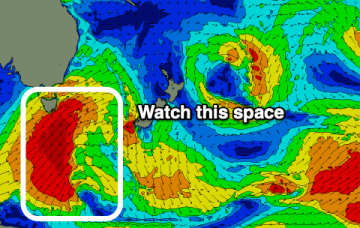
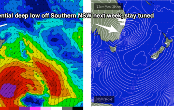
Further ahead and we’ll be tracking a potential south-wards moving coast-hugging low which is expected to form off the NSW or QLD coast later this weekend.
Primary tabs
/reports/forecaster-notes/eastern-tasmania/2022/06/27/s-swell-pulse-thurfri-potential-ne-swell-next
freeride76
Monday, 27 June 2022
/reports/forecaster-notes/eastern-tasmania/2022/06/24/flat-until-later-next-week
Craig
Friday, 24 June 2022
There's nothing to recommend over the coming period until late next week.
/reports/forecaster-notes/eastern-tasmania/2022/06/22/few-small-days-offer-mostly-offshore-winds
freeride76
Wednesday, 22 June 2022
Don’t expect much surf for the weekend, with cold and W’ly winds on offer and surf close to flat both days. A tiny wave Sat a’noon in the 1-1.5ft range may be surfable for chunky equipment.
/reports/forecaster-notes/eastern-tasmania/2022/06/20/few-fun-waves-week-the-ene-good-winds
freeride76
Monday, 20 June 2022
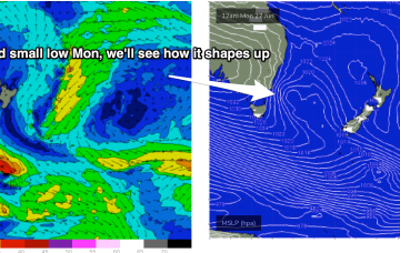
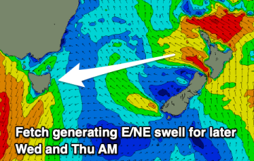
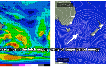
We’ve got a nice chunky 1033 hPa High slow moving at very southerly latitude, roughly triangulated between Tasmania and the South Island. As well as a precursor SE fetch adjacent to the South Island it is now squeezing pressure gradients with a compact, but deep low, which is currently forming gale force fetches out of Cook Strait and just north of the North Island. The Cook Strait fetch will produce some fun waves for East Tasmania.
/reports/forecaster-notes/eastern-tasmania/2022/06/17/easing-se-groundswell-followed-smaller-east
Craig
Friday, 17 June 2022
Today's large SE groundswell will ease over the weekend, with some weaker, smaller east swells to follow.
/reports/forecaster-notes/eastern-tasmania/2022/06/15/last-pulses-southern-swell-weekend-fresh-swell
freeride76
Wednesday, 15 June 2022
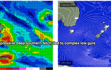
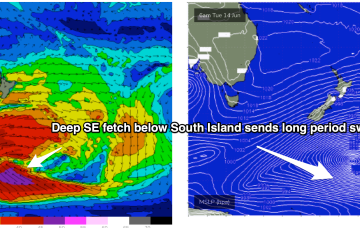
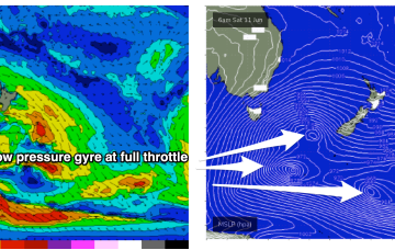
The Southern Ocean gyre is now well to the S and SE of the South Island, generating one last pulse of long period swell for our region.
/reports/forecaster-notes/eastern-tasmania/2022/06/13/energy-the-s-continues-most-the-week-mostly
freeride76
Monday, 13 June 2022
The Southern Gyre then sends one more pulse of SE groundswell our way later in the week.
/reports/forecaster-notes/eastern-tasmania/2022/06/10/icy-winds-the-sw-and-very-large-surf-sun
freeride76
Friday, 10 June 2022
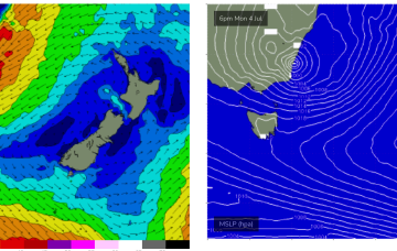
Sunday is a different story as storm force winds sweep past the state, bringing a S swell much larger than anything seen so far.
/reports/forecaster-notes/eastern-tasmania/2022/06/08/lots-large-s-swell-ahead-icy-offshore-winds
freeride76
Wednesday, 8 June 2022
Sunday is a different story. The most powerful front in the series sweeps up past the state with severe gale to storm force winds sling-shotting around the parent low.
/reports/forecaster-notes/eastern-tasmania/2022/06/06/multiple-large-s-swell-pulses-incoming-week
freeride76
Monday, 6 June 2022
High pressure support along an elongated front and another deep low pressure gyre forming well South-east of the South Island super-charge a deep southern fetch Fri into Sat with an area of 20ft seas sling-shotting agressively North-east into the Tasman Sea.