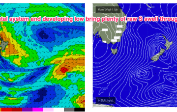
The energy cranks right up Wed across NENSW, trickling into SEQLD later in the day as strong winds to low end gales develop off the NSW South to Central Coast and into the Tasman and then push northwards around a trough.
Primary tabs
/reports/forecaster-notes/south-east-queensland-northern-new-south-wales/2025/06/02/windy-s-swell
freeride76
Monday, 2 June 2025
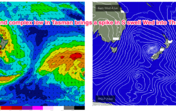
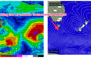
/reports/forecaster-notes/south-east-queensland-northern-new-south-wales/2025/05/30/s-swells
freeride76
Friday, 30 May 2025
We’ve currently got a deep polar low with two strong embedded fronts tracking NE into the lower Tasman. High pressure moves up over NSW with easing pressure gradients while a trough deepens off the QLD coast and drifts south over the weekend.
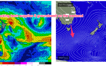
/reports/forecaster-notes/south-east-queensland-northern-new-south-wales/2025/05/28/sizey-the-s-usher
freeride76
Wednesday, 28 May 2025
A strong cold outbreak has led to the formation of a winter-calibre low in the Tasman (984hPa), backed by a strong, slow moving high in the Bight. We’re seeing the formation of strong S swells from this system, which will peak tomorrow then ease with a following front and deep low well to the south providing a strong S groundswell over the weekend under light winds.
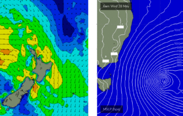
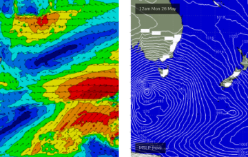
/reports/forecaster-notes/south-east-queensland-northern-new-south-wales/2025/05/26/stacks-south
thermalben
Monday, 26 May 2025
On Tuesday morning, a cold front will cross the Southern NSW coast, and a new low pressure system will then develop in the central/southern Tasman Sea during the day, strengthening overnight and stalling by Wednesday into a deep Tasman Low, a real beauty.
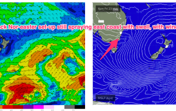
/reports/forecaster-notes/south-east-queensland-northern-new-south-wales/2025/05/23/great-weekend
freeride76
Friday, 23 May 2025
We’ll see plenty of residual swell from this low-carb nor-easter, with a slow easing trend over the weekend, more pronounced into next week.
/reports/forecaster-notes/south-east-queensland-northern-new-south-wales/2025/05/21/carbon-copies
thermalben
Wednesday, 21 May 2025
The trough will slowly turn south on Thursday, and then hasten its southerly track during the day, with the axis expected south of Coffs by Thursday night and Forster by Friday morning.
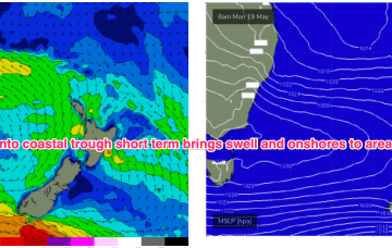
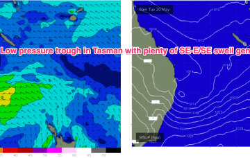
/reports/forecaster-notes/south-east-queensland-northern-new-south-wales/2025/05/19/complex-trough
freeride76
Monday, 19 May 2025
These small lows may move north, then east and finally south or may coalesce in a more classic Tasman Low or ECL variant. With so much uncertainty still around be prepared for major revisions as we move through the week. This is a nightmare to forecast!
/reports/forecaster-notes/south-east-queensland-northern-new-south-wales/2025/05/16/days-swell-and
freeride76
Friday, 16 May 2025
We’ve got good model agreement now that through Mon we’ll see a deep trough develop from the Coral Sea down to a terminus somewhere on the MNC to lower North Coast with good odds we will see a surface low develop at that terminus.
/reports/forecaster-notes/south-east-queensland-northern-new-south-wales/2025/05/14/light-winds-and
freeride76
Wednesday, 14 May 2025
Next week still looks dynamic with potential for a deep trough or low in the Tasman, although we are going to have to play it day by day due to poor model to model and run to run consistency
/reports/forecaster-notes/south-east-queensland-northern-new-south-wales/2025/05/12/winds-finally
freeride76
Monday, 12 May 2025
A broad trade fetch on steroids is now slowly breaking down through the Coral, Tasman and South Pacific with a tropical low whizzing away to the SE.
