Carbon copies ahead as a mid-strength black nor'easter continues to deliver

South-east Queensland and Northern NSW Surf Forecast by Ben Matson (issued Wed 19th May)
Features of the Forecast (tl;dr)
- Large onshore surf MNC Thurs, improving Fri as winds become light
- Large surf on the Northern Rivers Thurs/Fri (smaller but still solid SE Qld), clean on the points with good winds
- Great weekend of strong E'ly swells and light winds
- Smaller Mon/Tues with good winds for the beachies (NW)
- Solid though very inconsistent E'ly groundswell building Wed, peaking Thurs/Fri
- Sizeable S'ly swell building NNSW late Wed/peaking Thurs, easing Fri
- Favourable winds expected for this swell combo
Recap
Building SE swells have generated great waves across the points (those that have reclaimed their sand, anyway), reaching 6-8ft across Northern NSW but smaller to 4-5ft across SE Qld. Winds have been ideal for the points north from Yamba under a mainly S’ly flow, but we’ve seen poor conditions from Yamba south under heavy rain and fresh to strong onshore winds.

Superbank starting to show form again
This week (May 22 - 23)
Fresh easterly winds across Coffs Harbour and light variable winds throughout Yamba (oscillating between westerly and easterly) means the axis of the trough is meandering in the vicinity of the Clarence Coast right now.
The trough will slowly turn south on Thursday, and then hasten its southerly track during the day, with the axis expected south of Coffs by Thursday night and Forster by Friday morning.
This timing is important because it will dictate the onset of favourable conditions across the Mid North Coast - though water quality is expected to remain very suspect for quite a few days thanks to the considerable rainfall totals. So if you’re in this region please steer clear of rivers, creeks and other waterways.
The current synoptic set up is akin to a mid-strength black nor’easter, with an impressive fetch stretching all the way from Far Southern NSW to Fiji and Tonga. A new E’ly dip will become embedded in the trough line near New Caledonia on Friday but I’ll discuss this a bit further down.
As for size, we may see a touch more energy across exposed SE Qld coasts (say, 4-6ft) but surf size will generally be smaller running along the regional points. Northern NSW will hold steady in the 6-8ft range. Friday should remain similar.
Local winds should remain light offshore both days north from Yamba thru’ to the Sunshine Coast. So, expect almost a carbon copy of today for the rest of the week.
Thursday looks problematic along the Mid North Coast with onshores persisting for most of Thursday (though variable winds slowly extending from the north at some point, probably later). Light variable winds tending offshore are expected Friday, though without the presence of a stiff offshore to iron out the bumps, it will take a few hours for things to clean up.
This weekend (May 24 - 25)
The good news about the low-carb nor’easter is that the long fetch length means we’ll see only a slow decline in surf size once the swell window eventually quietens down.
And at this stage the fetch will remain active in the central/northern Tasman Sea swell window through Saturday, so the whole weekend will be flush with strong surf.
Even better - winds will remain light and variable both days under a weak ridge of high pressure.
SE Qld should meander in the 4-5ft range both days, with bigger 5-6ft sets across Northern NSW. Sunday could also see a minor reinforcement of E’ly swell from the aforementioned E’ly dip developing on Friday up near New Caledonia, though no major size increase is expected.
Next week (May 26 onwards)
The weekend's swell source will continue to slowly ease into next week, however we have some new swell on the way from the E’ly dip near New Caledonia.
This system looks magical on paper. The dip is expected to track slowly to the east - not always a good sign for our prospects - but it’ll broaden and intensify as a large high east of New Zealand tightens the squeeze to its north (see below), becoming almost stationary south-east from Fiji for a day or two.
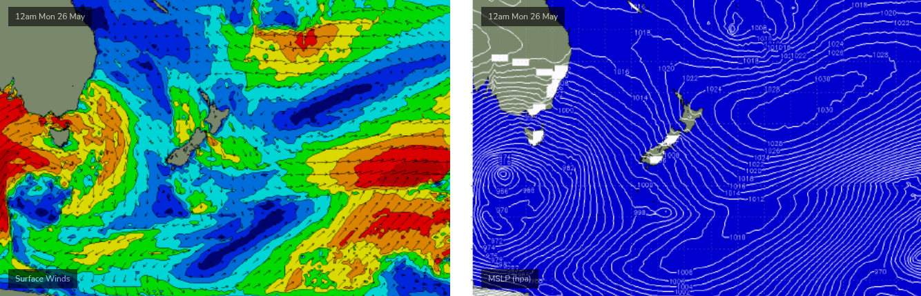
The travel distance from this system to the coast is much longer so we’ll see a smaller comparative size at the coast, however expectations are for an initial period of small background energy in the 3-4ft range Monday and Tuesday (clean with W/NW tending NW winds), before surf size builds slowly through Wednesday and peaks Thurs/Fri out of the E/NE. At its height we should be seeing solid 5-6ft+ sets across exposed coasts, though it will be quite inconsistent.
But that’s not the only swell source for next week.
A powerful Southern Ocean low and front will push across the SE corner of the country on Monday (see early stages above, in the Bight), and a broad fetch of SW tending S/SW winds across the south-western Tasman Sea will concurrently generate a series of large southerly swells for Northern NSW (smaller in SE Qld). Surf size should come up quickly on Wednesday afternoon (Mid North Coast), peak later Thursday and then ease through Friday.
At this stage the fronts are expected to track reasonably quickly into the Tasman Sea and therefore their influence on local winds may be only brief. As such the middle to latter part of next week is shaping up for an impressive, sizeable swell combo from the south and east with favourable winds to boot.
More on that in Friday's update.
Comments
Excellent!
The inside wide bank at Greenmount was firing this morning with the incoming tide. I managed to score two really long wide bomb sets with everyone out of position for it. The Superbank has really improved over the last couple weeks of consistent easterly swell. Definitely best on the incoming tide.
587mm recorded at Mt Seaview in the last 3 days (inland from Port Macquarie).
Yet another crazy rain event for the east coast.
Still really solid sets here this morning.
Glassy/lumpy conditions with more noise in the signal (short period swell trains running through it).
Dreamy swell direction for here (looks just south of due E) but the line-up is completely random.
Very heavy dew- would not be surprised to see a light NE Seabreeze puff up at some point.
Glassy 6ft+ sets on the Tweed, too big for most spots. Argh.
Nice to see the sun out though!
4th day of sun here- feeling for the people south of the trough getting smashed.
Paddle fest against sweep where I was this morning.
Some blokes may have got some good ones, I didn't. haha
Sounds just like Greenmount.
Had well over 300mm rain where I am. Luckily I'm elevated, looks like more to come yet.
Yep solid rain here. 250mm in last 24hr. Woke up at 4am to a waterfall running over the retaining wall. Had 50mm in 45 mins. Stopped now as it moves south
People lose their shit about 20mm over the day round here. Yikes!
It was cooking this morning. It's been a while since it's lined up that well. Plenty of waves for everyone. I'm fried.
paddle fest on the goldy on the central beachies, few corners and inside the points were working aswell. things are starting to recover. Interesting to note, the banks are generally sitting a fair way out, with a deep gutter closer in, making it very hard to get out and over the gutter onto the shallow sandbank.
Never thought these words would come out of my mouth, but I'll be so glad to see the back of autumn.
March was a write-off after Alfred, April had a few moments but no sand and May has been a sodden, soggy mess, even with plenty of swell.
For the first time today I felt the humidity drop out. It was as if, after a relentless wet signal, the atmosphere finally let out a deep exhale and it was time for autumn.
So does this mean you’re thinking charts also signalling a more autumnal pattern now?
Big cold front coming
Yep, ,more a straight switch to the winter pattern.
The price of Alfred!
I’m just looking for a sun forecast. Haven’t seen it since Sunday.
These rain events on the east coast are unprecedented, and don’t show any sign of letting up. The Hunga Tonga Volcano shot 150 million tons of water vapor in to the stratosphere, 30km - 54km up. A lot of the scientists studying it aren’t sure what the impacts will be as it’s something never seen or recorded before. Some of them say it could impact weather for a decade. Particular in the southern hemisphere. These troughs and cut off lows seem to stall and take a lot longer to clear the coast. What differences are you forecasters seeing with the high pressure systems in the pacific post Dec 2021. Is there a marked change?
Ain't small in Coffs this morning.
Interesting paddle out :-o
You'll have some good paddle-outs to look forwards to IB.
Old carcass pretty busted after three months of swell and great weather. Yesterday was incredible - like good Kirra.
Taking the day off, and preparing mentally :-)
Wow. I just went for a surf check and just saw...dead cows, wood, poison and oh so much plastic.
The missus reckons is not getting as much air time as the se Qld/northern rivers event a couple of years ago but this is just as bad, if not worse. We've lived through both unfortunately! Anyway, shits fucked; the future is now.
Beachies on the SC were freaking glorious this morning! Peaky, light offshore, few round ones....as Les Norton would say 'wouldn't be dead for quids'
Blue sky, all day offshore, boardies, spitting barrels everywhere, 6 hours cooked, still coming through too. Slow periods, straight here and there, but what a day, finally.
How good are the empty sessions you get with just a handful of local crew on a week day, then you can paddle out amongst the weekend hordes and not even care. Moffs Trilogy IPA is a bloody good drop too.
Love this!
Ah ya killing me Sprout.
Really should have taken a couple of days off!
Yes, Trilogy is delicious, enjoy!
Yep it was cooking ... still is
Yep SC is where it’s at today. Pumping all day. I missed it but my mates have happily sent me pics of what they scored all day!! :(
Tools down at smoko today
The Sunny Coast sucks until it doesn't. Had 3x 2 hour seshs, 15 minute breaks in between of scoffing down jerky and water in between to run back out. Bodys cooked, time to do some stretching.
Yep if only it was a more common occurrence!!