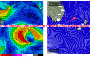
Under current modelling, most major models have TC Alfred, or a sub-tropical cyclonic descendant of it, slow moving off the SEQLD coast early next week possibly drifting erratically through the whole week. That leads to high confidence for an extended period of very large surf in the sub-tropics, possibly of an historic nature in terms of size and duration.
Primary tabs
/reports/forecaster-notes/south-east-queensland-northern-new-south-wales/2025/02/28/extended-period
freeride76
Friday, 28 February 2025
/reports/forecaster-notes/south-east-queensland-northern-new-south-wales/2025/02/26/three-cyclones
freeride76
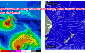
Wednesday, 26 February 2025
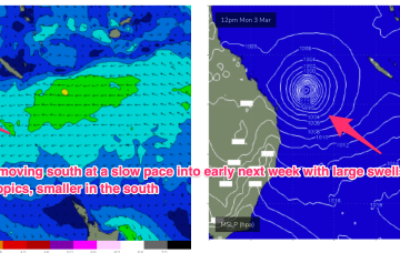
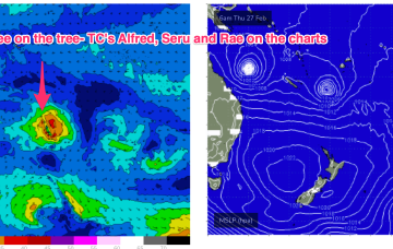
TC Alfred is in the Coral Sea, currently about a 1000km NE of Mackay and slow moving, expected to slowly track southwards from today. TC Rae has sped off SE to the graveyard and TC Seru is located between Vanuatu and Fiji and moving S/SE. In this complex brew, we’ll see multiple swell trains from the NE-E quadrant, although large swells may be confined to more northerly regions as models firm on a CQ coastal crossing for TC Alfred (still uncertainty over this track!) and the South Pacific cyclones track south-eastward, then eastwards as dissipating systems.
/reports/forecaster-notes/south-east-queensland-northern-new-south-wales/2025/02/24/plenty-trade
freeride76
Monday, 24 February 2025
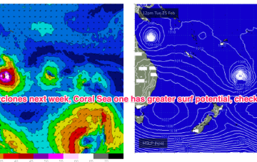
A very long and broad tradewind fetch is anchored on a NW/SE axis by twin tropical cyclones. TC Alfred is meandering in the Coral Sea NE of Cairns, while TC Rae is NW of Fiji and moving south-south westwards.

/reports/forecaster-notes/south-east-queensland-northern-new-south-wales/2025/02/21/another-round
freeride76
Friday, 21 February 2025
The monsoon trough is still active with a tropical low off the N.QLD coast and lows in the South Pacific through the Island chains. Medium term surf potential rests on these tropical lows, with the supporting tradewind belt supplying plenty of energy in the interim, focussed on the sub-tropics.
/reports/forecaster-notes/south-east-queensland-northern-new-south-wales/2025/02/19/temporary-easing
freeride76
Wednesday, 19 February 2025
Following that, we’ll see a fallow period while we wait for the next round of Tradeswell to develop next week, possibly enhanced by tropical low pressure systems in the South Pacific and Coral Sea.
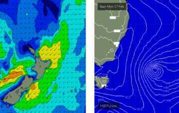
/reports/forecaster-notes/south-east-queensland-northern-new-south-wales/2025/02/17/dueling-swells
thermalben
Monday, 17 February 2025
Make the most of Tuesday and Wednesday as it’s shaping to be the best run of surf we’ve seen this season, pretty much everywhere.
/reports/forecaster-notes/south-east-queensland-northern-new-south-wales/2025/02/14/excellent-run
thermalben
Friday, 14 February 2025
Great waves are expected across most coasts, on most days.
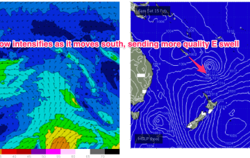
/reports/forecaster-notes/south-east-queensland-northern-new-south-wales/2025/02/12/lots-more-e-swell
freeride76
Wednesday, 12 February 2025
The low is slow moving as it slides to the SE of New Caledonia and looks to be reinforced by a second tropical low budding off the monsoon trough in North QLD waters. We’ll see continuing E’ly swells from this source, with a long lasting peak as the system intensifies as it drifts through the South Pacific slot over the weekend.
/reports/forecaster-notes/south-east-queensland-northern-new-south-wales/2025/02/10/slow-steady
freeride76
Monday, 10 February 2025
The slow moving low in the South Pacific slot has a very broad, almost semi-stationary fetch on its southern flank, buttressed by high pressure over New Zealand. This is likely to see a fully developed sea state with plenty of sizey mid period E swell across most of the eastern seaboard.

/reports/forecaster-notes/south-east-queensland-northern-new-south-wales/2025/02/07/upgraded-outlook
freeride76
Friday, 7 February 2025
New high pressure moves SE of Tasmania to start next week and compared to Wed’s notes it’s looking stronger and slower moving, which is good news for surf potential, especially medium term as it anchors low pressure drifting down from the tropics into the wide open South Pacific slot.