We’ll see the current dominant high (1034hPa) straddling New Zealand which is directing a broad trade fetch through the South Pacific and into the Coral Sea slowly migrate eastwards this week with an E’ly dip forming a trough of low pressure due E of SEQLD mid week.
Primary tabs
/reports/forecaster-notes/south-east-queensland-northern-new-south-wales/2025/05/05/spell-smaller
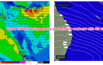
freeride76
Monday, 5 May 2025
/reports/forecaster-notes/south-east-queensland-northern-new-south-wales/2025/05/02/fun-blend-se-and
freeride76
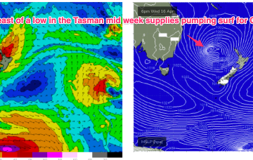
Friday, 2 May 2025
Following a fun south-east pulse for the weekend, east energy ramps up later next week.
/reports/forecaster-notes/south-east-queensland-northern-new-south-wales/2025/04/30/extended-run
freeride76
Wednesday, 30 April 2025
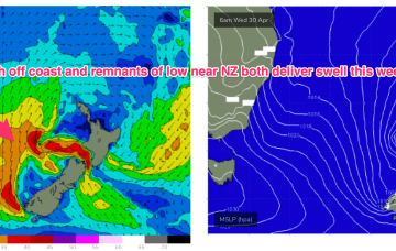
We’re seeing a ramp up in strong S’ly winds along the eastern seaboard as a dominant high (1035hPa) moves through the eastern Bight towards Tasmania with a trough on it’s leading edge moving northwards. Remnants of a low on the weekend are also sitting near New Zealand with swell generating fetches off the South Island and emerging from Cook Strait into the eastern Tasman.
/reports/forecaster-notes/south-east-queensland-northern-new-south-wales/2025/04/28/plenty-robust-s
freeride76
Monday, 28 April 2025
We’ll see another front and trough develop mid week on the leading edge of the dominant high, which sees a strong S/SE-SE fetch develop through the lower Tasman from mid week. Plenty of swell from this source with a strong ridge along the NSW seeing fresh S’lies, easing into the weekend.
/reports/forecaster-notes/south-east-queensland-northern-new-south-wales/2025/04/25/plenty-surf-ahead
thermalben
Friday, 25 April 2025
This combo of low period and southerly swell direction doesn’t make sense for Far Northern NSW and SE Qld, but good surf has eventuated quite a few times before.
/reports/forecaster-notes/south-east-queensland-northern-new-south-wales/2025/04/23/onshore-winds
freeride76
Wednesday, 23 April 2025
We’ve got a slow moving high sitting east of Tasmania and a trough of low pressure off the North Coast directing an onshore flow across most of the Eastern Seaboard and generating plenty of local swell.

/reports/forecaster-notes/south-east-queensland-northern-new-south-wales/2025/04/21/small-mixed-bag
freeride76
Monday, 21 April 2025
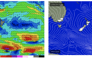
We’ll see the trough bring onshore winds and swell as it moves up the NSW Coast through the first half of this week. That will mostly obscure some traces of long period S swell pushing up the Tasman. A distant low in the South Pacific currently in Tongan latitudes will send some small but good quality E’ly swell late this week, with more favourable winds.
/reports/forecaster-notes/south-east-queensland-northern-new-south-wales/2025/04/18/solid-weekend
thermalben
Friday, 18 April 2025
We’ve already reached the peak of this impressive event and so we’re looking at a steady drop in size both Saturday and Sunday.

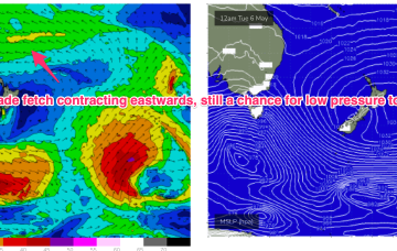
/reports/forecaster-notes/south-east-queensland-northern-new-south-wales/2025/04/16/large-se-swells
freeride76
Wednesday, 16 April 2025
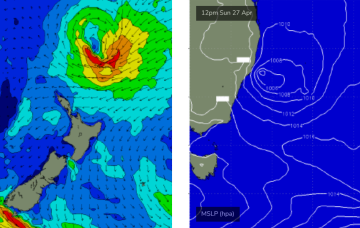
After a binary interaction between the two systems, the merged low transitions into a storm force sub-tropical low which tracks SW into the Northern Tasman. This storm force low has a broad fetch aimed directly at the East Coast, generating a large E’ly quadrant swell for Good Friday and the Easter weekend with uncommonly large swell periods for swells from that direction.
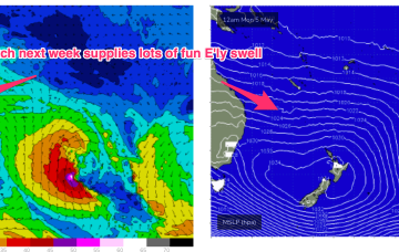
/reports/forecaster-notes/south-east-queensland-northern-new-south-wales/2025/04/14/chunky-trade
freeride76
Monday, 14 April 2025
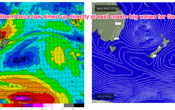
We’ve got a very dynamic week ahead, anchored by very strong high pressure moving into the far-southern Tasman and acting as anvil for a deep low which is expected to form in the tropical South Pacific between New Caledonia and Vanuatu o/night into tomorrow before drifting SW into the Tasman as a deep, extra-tropical low pressure system. This system intensifies through the week and is now expected to generate a large E’ly quadrant swell for the Eastern Seaboard heading into and over the Easter weekend.