High pressure is in the Tasman in typical spring position- with a N’ly flow being enhanced as a mid-latitude low approaches from well south of the Bight.
Primary tabs
/reports/forecaster-notes/south-east-queensland-northern-new-south-wales/2025/09/15/typical-spring
freeride76
Monday, 15 September 2025

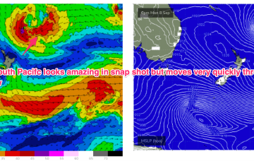
/reports/forecaster-notes/south-east-queensland-northern-new-south-wales/2025/09/12/small-clean-s
freeride76
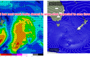
Friday, 12 September 2025
Nothing major on the radar next week so we’ll be relying on small S pulses for a wave at S magnets.
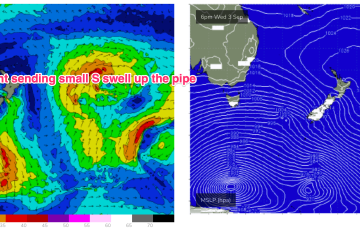
/reports/forecaster-notes/south-east-queensland-northern-new-south-wales/2025/09/10/brief-spike-in-s
freeride76
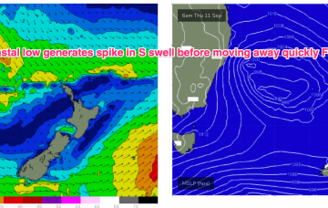
Wednesday, 10 September 2025
We should then see a low centred just off Sydney rapidly deepen o/night into tomorrow morning with NW’ly winds across the region shifting W-SW through the day. The low moves away quickly tomorrow with winds moderating quickly into and through Friday.
/reports/forecaster-notes/south-east-queensland-northern-new-south-wales/2025/09/08/nothing-special
thermalben
Monday, 8 September 2025
So for all intents and purposes we can expect an ordinary run of waves in the short term, with mainly small residual swells (NE windswell and minor S’ly groundswell) along with freshening northerly winds on Tuesday and Wednesday.
/reports/forecaster-notes/south-east-queensland-northern-new-south-wales/2025/09/05/rideable-fathers
freeride76
Friday, 5 September 2025
We’ll see some waves for Fathers Day. Nothing exceptional or inspiring but winds should lay down with light breezes all day, tending NE in the a’noon so workable conditions for most of the day, perhaps requiring a good backbench in the a’noon.
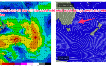
/reports/forecaster-notes/south-east-queensland-northern-new-south-wales/2025/09/03/small-and-the-s
freeride76
Wednesday, 3 September 2025
A trough and strong high pressure ridge behind this front sends a robust SE surge up the coast, bringing some swell favouring the sub-tropics before it eases over the weekend.
/reports/forecaster-notes/south-east-queensland-northern-new-south-wales/2025/09/01/small-s-pules
freeride76
Monday, 1 September 2025
Still on track for S pulses this week for the first week of spring. No “direct hits”- it’s all wrapping into the Tasman from deep southern and fast moving fronts under Tasmania so S swell magnets in NENSW will be favoured and only the most reliable S magnets in SEQLD will see any meaningful surf.
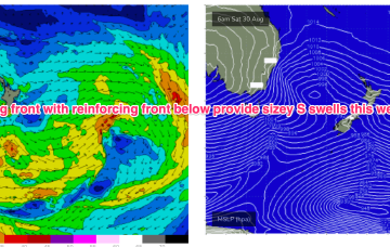
/reports/forecaster-notes/south-east-queensland-northern-new-south-wales/2025/08/29/s-swell-spike
freeride76
Friday, 29 August 2025
Still on track for a wintry blast this weekend as a strong cold front tied to an intense low currently west of Tasmania sweeps up over the SE overnight and enters the Tasman early tomorrow morning.
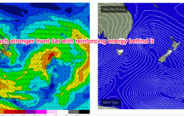
/reports/forecaster-notes/south-east-queensland-northern-new-south-wales/2025/08/27/offshores-and-e
freeride76
Wednesday, 27 August 2025
Winds shift W’ly as the initial frontal system sweeps across NSW tomorrow, with a stronger front and low moving up over NSW and then entering the Tasman with a vengeance into the weekend. We’ve still got some E’ly swell inbound from a retreating low which fired up as it approached the North Island.
/reports/forecaster-notes/south-east-queensland-northern-new-south-wales/2025/08/25/quality-e-swells
freeride76
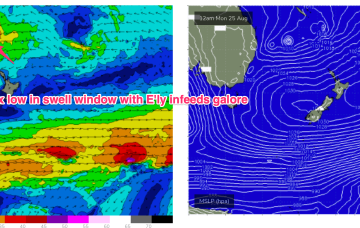
Monday, 25 August 2025
These low centres are focussing areas of E’ly infeed along the trough line- perfectly aimed at east coast targets.