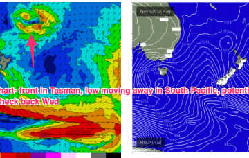
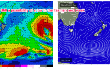
Once again, we’re in a position of enhanced instability in the Tasman and Coral Seas with models really struggling to resolve the troughiness.
Primary tabs
/reports/forecaster-notes/sydney-hunter-illawarra/2025/08/11/troughy-pattern-continues-low-pressure
freeride76
Monday, 11 August 2025
/reports/forecaster-notes/sydney-hunter-illawarra/2025/08/08/fading-east-swells-dicey-winds
thermalben
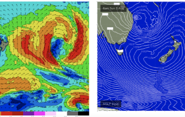
Friday, 8 August 2025
The large east swell will continue to ease as conditions remain less than ideal.
/reports/forecaster-notes/sydney-hunter-illawarra/2025/08/06/slow-easing-in-e-swell-winds-shifting
freeride76
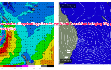
Wednesday, 6 August 2025
No great change to the f/cast for the week. The slowly retreating fetch is continuing to send strong E swells with just slow easing trend in play.
/reports/forecaster-notes/sydney-hunter-illawarra/2025/08/04/clean-and-big-short-term-slow-easing
freeride76
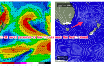
Monday, 4 August 2025
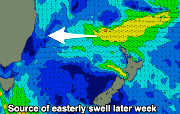
Current ASCAT (satellite wind speed) pass shows a low in the Northern Tasman with SE gales proximate to the NSW Coast and a long, broad fetch of E’ly gales extending from the Tasman out to a position north of the North Island.
/reports/forecaster-notes/sydney-hunter-illawarra/2025/08/01/pumping-e-swell-days-next-week-improving
freeride76
Friday, 1 August 2025
If anything that eastwards movement looks slower than modelled on Wed so large surf will persist at elevated levels for longer.
/reports/forecaster-notes/sydney-hunter-illawarra/2025/07/30/extended-large-ely-swell-event-intense
freeride76
Wednesday, 30 July 2025
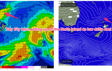
E’ly gales in a broad fetch remain into the new week with a massive high new New Zealand (1042hPa) acting as supporting cradle for the Tasman low which will be drifting eastwards to a slot north of the North Island.
/reports/forecaster-notes/sydney-hunter-illawarra/2025/07/28/unstable-week-ahead-dynamic-weekend
freeride76
Monday, 28 July 2025
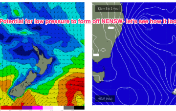
Over the weekend there’s now growing agreement on a coastal low (possibly some variant of an ECL) to form off the NENSW or SEQLD coast and intensify as it moves into the Tasman, with potential for severe weather and sizey swells.
/reports/forecaster-notes/sydney-hunter-illawarra/2025/07/25/ne-windswell-short-term-uncertain
freeride76
Friday, 25 July 2025
Low pressure formation looks likely, possibly a strong cut-off low moving into the Tasman Thurs and offering an initial spike in S swell Thurs before better angled S/SE swell into the weekend if the low hangs around in the south-east Tasman near the South Island.
/reports/forecaster-notes/sydney-hunter-illawarra/2025/07/23/ne-windswell-ahead-then-s-swells-medium
freeride76
Wednesday, 23 July 2025
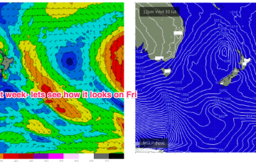
EC has a much more bullish outlook with a robust cut-off low sitting in the Tasman for the second half of next week.
/reports/forecaster-notes/sydney-hunter-illawarra/2025/07/21/downgraded-e-swell-still-offers-some-fun
freeride76
Monday, 21 July 2025
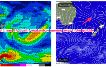
Unfortunately, compared to Fridays expectations the interplay between these two systems is weaker, with a more constrained fetch of lower windspeeds that drifts away quicker than modelled on Friday. That will result in smaller east quadrant swell this week, relative to Fridays expectations.