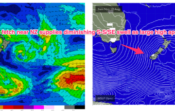
An ice shelf fetch over the weekend looked strong on paper but the extent to which winter sea ice has hindered swell generation remains a key source of uncertainty.
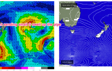
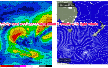
Primary tabs
/reports/forecaster-notes/sydney-hunter-illawarra/2025/09/01/small-s-pules-week-mostly-offshore-winds
freeride76
Monday, 1 September 2025
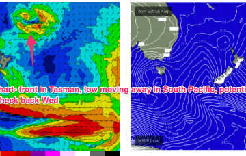
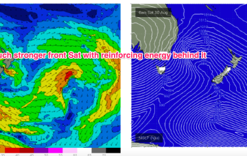
/reports/forecaster-notes/sydney-hunter-illawarra/2025/08/28/strong-cold-front-brings-spike-in-s
freeride76
Friday, 29 August 2025
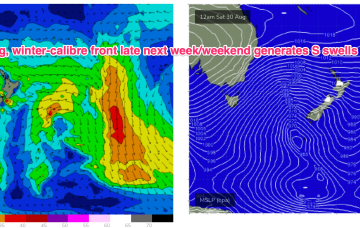
Still on track for a wintry blast this weekend as a strong cold front tied to an intense low currently west of Tasmania sweeps up over the SE overnight and enters the Tasman early tomorrow morning.
/reports/forecaster-notes/sydney-hunter-illawarra/2025/08/26/winter-blast-ahead-end-the-season
freeride76
Wednesday, 27 August 2025
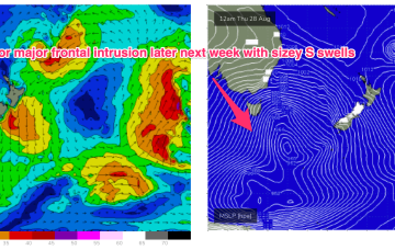
Winds shift W’ly as the initial frontal system sweeps across NSW tomorrow, with a stronger front and low moving up over NSW and then entering the Tasman with a vengeance into the weekend.
/reports/forecaster-notes/sydney-hunter-illawarra/2025/08/24/quality-e-swells-fade-through-the-week
freeride76
Monday, 25 August 2025
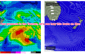
These low centres are focussing areas of E’ly infeed along the trough line- perfectly aimed at east coast targets.
/reports/forecaster-notes/sydney-hunter-illawarra/2025/08/22/active-period-ahead-quality-the-e-next
freeride76
Friday, 22 August 2025
Plenty of chunky short range S swell through Sun as the low generates a proximate fetch of S’ly low end gales along the south coast to Hunter.
/reports/forecaster-notes/sydney-hunter-illawarra/2025/08/19/la-niñ-pattern-short-term-looking-more
freeride76
Wednesday, 20 August 2025
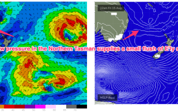
We’ll see the E’ly flow continue to develop in the Northern Tasman and Coral Seas through this week, with swells from that E-NE quadrant building through this short term period under an onshore flow.
/reports/forecaster-notes/sydney-hunter-illawarra/2025/08/18/another-ely-episode-ahead-rain-onshores
freeride76
Monday, 18 August 2025
The dominant player is a massive high moving through the Bight and expected to drift over and eastwards of Tasmania tomorrow to occupy the Tasman for most of the week.
/reports/forecaster-notes/sydney-hunter-illawarra/2025/08/15/small-blend-over-the-weekend-unstable
freeride76
Friday, 15 August 2025
Back to looking dynamic next week. The crux of it is another very strong high moving at Tasmanian latitudes early next week. That will be the anvil for any hammer that forms next week.
/reports/forecaster-notes/sydney-hunter-illawarra/2025/08/13/surf-the-small-side-conditions-look-good
freeride76
Wednesday, 13 August 2025
The trough forms a broad surface low that briefly flares up as it drifts towards the North Island and interacts with a more tropical derived low.
/reports/forecaster-notes/sydney-hunter-illawarra/2025/08/11/troughy-pattern-continues-low-pressure
freeride76
Monday, 11 August 2025
Once again, we’re in a position of enhanced instability in the Tasman and Coral Seas with models really struggling to resolve the troughiness.