Plenty of activity and better conditions at metro regions
Best days: Saturday at Perth and Mandurah, Sunday at Perth and Mandurah, Monday morning at Margs and Monday at Perth and Mandurah.
Features of the forecast
- Large but inconsistent SW groundswell Sat
- Onshore at Margs, light E/NE winds for Perth and Mandurah Sat AM going onshore in the PM
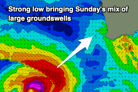
- XL SW pulse for Sunday PM
- Variable winds for Perth and Mandurah, onshore at Margs
- Easing into Monday with good winds at Margs in the AM
- Good winds at metro regions through Monday
- Onshore from Tue through to next weekend at all locations
- Large WSW surf building Wednesday PM through the weekend, turning SW into Fri/Sat
Recap
Today and yesterday saw mostly poor conditions across the coast with onshore winds, although Perth had clean-ish conditions yesterday morning with slow 2ft sets as the large Wednesday swell eased. Today we had a building localised swell but wind affected.
This weekend (June 14 - 15)
For Saturday there is not much change to the last notes with a larger but inconsistent groundswell filling in from a broad frontal progression that pushed west towards WA, which will reach 6ft+ around Margs, 2-3ft at Mandurah and 2ft+ at Perth. Winds are better up north being light E/NE in the morning turning NW into the afternoon, and Margs may see a window early morning tomorrow with NNE breezes strengthening out of the NW/W through the day.
The SW pulse expected on Sunday afternoon has now been bumped up as the low forming over the weekend to the south-west is forecasted to have stronger winds of 55knots+ projecting closer to the coast and expanding as it moves past, with a fetch well aimed at Margs sending 12ft+ of surf into the afternoon, with 3-4ft Mandurah and 2-3ft+ at Perth. Quality won’t be the best down south with onshore winds as the low crosses the coast but metro regions should see variable winds and better conditions.
Next week (June 16 - 20)
As the low moved so close to the coast sending a large pulse and kept tracking east, we can expect sizes to rapidly ease through Monday, however early morning is looking like a good window for Margs with E/NE winds and the swell still at 8ft before it drops and winds tend WNW. If you can shuffle things around to squeeze a surf in, Monday morning looks like a good day.

The easing trend continues through Tuesday being tiny up north and blown out at Margs with a building wind swell, while we wait for more energy due on Wednesday afternoon and into the weekend.
Later into Wednesday we have a building pulse of long-range WSW groundswell produced by a broad front with a fetch of gale force winds that moves west over mid-latitudes before it dips away. This should build to 6-8ft at Margs in the afternoon and 2ft at metro regions, but by then the winds will be freshening out of the NW/W at Margs and W/WSW up north, deteriorating conditions.
We have another frontal progression moving closer to the coast on Tuesday/ Wednesday, adding to the mix some growing WSW mid-period reinforcing energy that arrives into Thursday and sends sizes up to 8ft at margs in the morning, building to 10ft into the afternoon and Friday, with Perth seeing 3ft on Thursday and 4ft on Friday, however the whole coast is onshore from Thursday into the weekend.

The early stages of that front, which is this Sunday/Monday, moves past South Africa before it approaches WA with a broad fetch of winds up to storm force that will produce a mix of large SW groundswells that arrive after the closer range mid-period we will see on Thursday. This should reach 12-15ft at Margs on Friday afternoon, 4ft at Perth and Mandurah.
The weekend should see a slowly easing trend, but we will provide an update next week on how things develop.
Have a great weekend!