Indonesia/Maldives forecast Aug 5

Indian Ocean Basin analysis by Craig Brokensha (issued Tuesday 5th August)
This week through next (Aug 6 - 15)
A large SW groundswell filled in through yesterday and it should be reinforced by a secondary large pulse of S/SW groundswell this morning.
This is the lemon next to the pie though, with a much larger, more powerful S/SW groundswell expected to impact the region this evening, peaking through tomorrow morning.
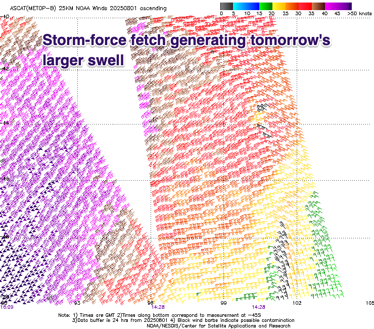
As touched on in last week’s updates, the source was a significant polar low forming around the Heard Island region Thursday evening, generating an initial storm-force SW fetch before slowly weakening while projecting up and into Western Australia,
This brought XL, stormy surf to their region on Sunday/Monday with the long-period energy now on the way towards Indonesia.
Size wise we’re still expecting exposed breaks to come in at 10-12ft, easing through the day, smaller into Thursday.
A good reinforcing pulse of large S/SW groundswell is also on the cards for Friday, produced by a slightly more easterly located polar frontal progression, later in our swell window. Still, a fetch of gale to severe-gale W/SW winds should produce a large S/SW swell for Friday, peaking through the day before easing into the weekend.

Longer term, the next increase in groundswell looks to occur through early next week with a healthy frontal system that’s currently pushing up and across the Heard Island region expected to project a fetch of SW gales towards us. A large S/SW groundswell is due from this system Monday, peaking into the afternoon.
Following this the longer term is quieter so make the most of the current and coming energy.
Winds tomorrow look great with moderate to fresh E/SE trades, easing a little later week before tending more E/SE-SE, SE over the weekend. Freshening E/SE-SE winds will kick up again through next week and local, light land breezes are due every morning.
In the Mentawais the large swell energy now in the water will be backed up by the larger increase in S/SW groundswell tomorrow, with the reinforcing pulse for Friday arriving a touch more S’ly and a little smaller than eastern locations.
Local winds are easing from the N/NW-NW and should become more variable over the coming days and into the weekend, remaining so next week. We might see SE winds strengthen mid-late next week across southern locations.
----------------------------------------------
Maldives:
We’ve got a moderate + sized S/SE trade-swell in the water thanks to a great fetch of S/SE trades firing up south of us over the weekend, but this has since weakened and migrated east, resulting in a slow drop in size over the coming days.
In saying that a small low has formed in the trade-flow to the south-west of Sumatra, resulting in a final pulse of SE trade-swell energy for Friday/Saturday, easing thereafter.
S’ly groundswell wise, the system pushing up and across the Heard Island today and tomorrow should generate a moderate sized S’ly groundswell for Monday before easing thereafter.
Longer term the trade-flow might set up again for later next week, but more on this next update.
Local winds are gusty out of the W/NW-NW but are due to weaken over the coming days, light W’ly into Friday. Weak W/SW-SW winds are then due on the weekend before freshening from the W/SW again into next week.
Eastern Indonesia:
Oversized, long-period S/SW groundswell for tomorrow morning, peaking to 10-12ft across exposed breaks, easing later and into Thursday.
Large, reinforcing S/SW groundswell for Friday, peaking during the day to 8ft, easing into the weekend.
Large S/SW groundswell for Monday, peaking into the afternoon to 6ft+ across exposed breaks, smaller through the week.
Moderate to fresh E/SE trades, easing a little later week before tending more E/SE-SE. SE over the weekend. Freshening E/SE-SE winds next week, with local, light land breezes are due every morning.
Uluwatu 16-day Forecast Graph/WAMs
Western Indonesia/Mentawais/South Sumatra:
Large S/SW groundswell for tomorrow to 10ft across exposed breaks, easing into Thursday.
Mod-large, reinforcing S’ly groundswell Friday to 6ft across exposed breaks.
Large S/SW groundswell for Monday to 6ft+ across exposed breaks, easing slowly Tuesday.
Variable winds developing over the coming days, possibly freshening from the SE mid-late next week.
Mentawai 16-day Forecast Graph/WAMs
Maldives:
Moderate + sized S/SE trade-swell peaking today to the 5ft range across the southern atolls, easing slowly over the coming days (smaller Male).
Moderate sized SE trade-swell for Friday afternoon and Saturday morning to 4ft+, easing thereafter (slightly smaller Male).
Moderate sized S’ly groundswell for Monday to 4ft+ across the southern atolls (smaller Male).
Gusty, easing W/NW-NW winds over the coming days, lighter into Friday and W/SW-SW from the weekend.
Winds possibly freshening from the W/SW next week.
Comments
Latest notes are live.
Hey Craig - not seeing the big Wednesday swell on the forecast pages for Nias/Simulue, but it is showing up for the Ments. Wondering if this is because the swell was outside the swell window for Nias/Simulue?
P.s I’m in Banyaks thus trying to get a feel for what to expect here
6’ sets odd bigger clean up in the Telos this morning Pngy it’s on the way
If you're talking about tomorrow it's showing also on the Nias forecast page, just a bit later into tomorrow afternoon (1.5m @ 18.1s tomorrow lunch and then 1.7m @ 17.6s tomorrow evening).
https://www.swellnet.com/reports/indonesia/sumatra/nias/forecast
It is quite south in direction so that will limit your options up in the banyaks for breaks. And the one that does like a more south swell direction does not like super long swell periods like those above. Creates some heaving slabs on the takeoff ledge.
ignore the models, Read Craig's fcst. It's going to a banger south swell
ignore the models, Read Craig's fcst. It's going to a banger south swell