Best today, tricky otherwise

Western Australian Forecast by Craig Brokensha (issued Wednesday May 11th)
Best Days: Today Perth and Mandurah, Perth and Mandurah Saturday morning, Monday morning all locations
Features of the Forecast (tl;dr)
- Easing W/SW swell tomorrow with freshening NE tending N-N/NW winds across metro locations, N/NW in the South West
- Building localised swell Fri with strong NW tending SW winds
- Moderate + sized W/SW groundswell for Sat/Sun
- E/NE-NE tending NW winds Sat across metro regions, strengthening W/NW in the South West
- Large mix of SW groundswells filling in Sun with strong W/SW tending SW winds
- Steadily easing swell Mon with NE tending stronger NW winds
Recap
Yesterday was fairly poor and onshore across all locations while today we’ve got our oversized W/SW groundswell in the water with the Margaret River region coming in at an easy 12ft with solid sets across the metro regions with more favourable, variable winds.
This week and next (Jun 12 - 20)
Make the most of today’s variable winds and large swell across the metro regions as into tomorrow we’ll see easing levels of swell under a freshening NE tending N-N/NW breeze (N/NW from early down in the South West).
This will be thanks to a weak frontal system approaching, bringing with it stronger NW tending SW winds on Friday as it clips the state.
Swell wise, some sizey but low period W/SW swell is due to fill in, with it easing into Saturday as our stronger, inconsistent groundswell fills in.

As discussed on Monday, the source was a broad and expansive frontal progression pushing across the Heard Island region though a little patchy in structure. Multiple pulse of swell are due from Saturday through Sunday, with Perth likely to come in at 2ft+, 2-3ft Mandurah and 6ft+ across the South West.
Local winds will on Saturday morning look best across the metro regions and E/NE-NE through the morning, strengthening W/NW across the South West with the next approaching frontal system. There’s an outside chance of variable winds at dawn but we’ll review this Friday.
We’re looking at another tight, intense low moving in from the south-west on the weekend, with it forecast to generate a pre-frontal severe-gale W/NW winds followed by slightly stronger W/SW winds around the core of the low.
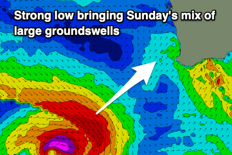
Both swells from the low are due to build through Sunday, peaking later with the South West due to build to 10ft+, 3ft+ Mandurah and 2-3ft Perth later.
Winds for this swell look W/SW tending SW across all locations as the swell generating system clips us, better Monday morning as the swell eases steadily under light to moderate NE tending stronger NW winds.
The shift in winds will be ahead of the next swell generating frontal progression, with plenty of activity due into the weekend and next week, generating large pulses of swell but with generally poor, onshore winds as each system pushes far north in latitude. More on this Friday.